Posts

Showing posts from March, 2009

March Madness

Image
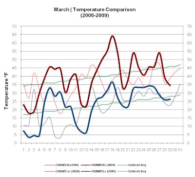
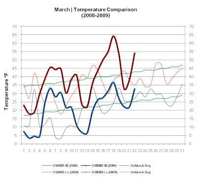
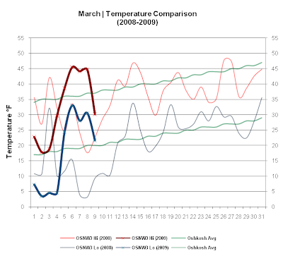
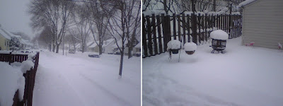
This past week brought drenching rains and accumulating snows. Temperatures swung up and down as one would expect for late March. March is currently 162% of average for precipitation and 118% of average for snowfall. An exciting week is in store once again for the upper Midwest. Looking forward to it. ( OSNW3 March Observations ) (Temp Comparison 2008 / 2009 | March 1 - 29) Max temp: 35.5 / 39.6 / +4.1 Min temp: 20.8 / 22.8 / +2.0 (March 2009 Precipitation | March 1 - 29) 2009 Monthly Total Precip.. 3.53" Snow.... 9.0" Oshkosh Average Precip.. 2.18" Snow.... 7.6" Departure Precip.. +1.35 Snow.... +1.4" ---- Late March Flooding The 48 hours ending Mar 25 brought some decent rains. A two day total of 1.82". The rain fell quick and with the ground not completely thawed, some minor flooding occurred. The water crept into our basement, but nothing unusual after a heavy rain like this. (OSNW3 Flooding - Mar 25, 2009) ---- Snowfall Mar 28-29 A Winter We

Spring Has Arrived

Image
This past week was warm, relatively speaking. Four consecutive days saw max temps 50° or above. Mar 17 had the third highest max temp ever recorded at OSNW3 in the month of March, topping out at 64.2°. We also saw the season transition from Winter to Spring this past week which in the end brought an accumulating snowfall on the first day of Spring. ( OSNW3 March Observations ) (Temp Comparison 2008 / 2009 | March 1 - 22) Max temp: 34.2 / 38.3 / +4.2 Min temp: 18.4 / 20.3 / +1.9 (March 2009 Precipitation) 2009 Monthly Total Precip.. 1.54" Snow.... 7.6" Oshkosh Average Precip.. 2.18" Snow.... 7.6" Departure Precip.. (0.64") Snow.... +0.0" ---- Snowfall Mar 21 Winter delivered a goodbye snowfall (1.0" measured @ 1:38am on Mar 21 - Total 1.0") ( radar loop / daily video ) ---- Winter Duration Winter ended at OSNW3 the same day as Spring began astronomically, Mar 20, 2009. According to the Winter Duration formulas here at OSNW3, Winter began

Winter Wane

Image
This past week started out warm, then cooled, then warmed back up again. Typical March temperature swings. Precipitation was bountiful early on as well. As Winter slowly draws to an end, the warmth of the sun, the sloppiness of the snow melt, and the early morning chirping birds are giving me the itch. The Spring Itch. However, I am looking forward to a couple Spring snowfalls, don't get me wrong. I can't quit Winter cold turkey. ( OSNW3 March Observations ) (Temp Comparison 2008 / 2009 | March 1 - 15) Max temp: 32.8 / 33.1 / +0.3 Min temp: 15.4 / 16.5 / +1.1 (March 2009 Precipitation) 2009 Monthly Total Precip.. 1.47" Snow.... 6.6" Oshkosh Average Precip.. 2.18" Snow.... 7.6" Departure Precip.. (0.71") Snow.... (1.0") ---- Data Bounty! About a year ago I inquired the NWS Green Bay Climate Program Leader, Roy Eckberg, about obtaining the Monthy Snowfall data for the Oshkosh COOP station, OKHW3 . This past week I inquired about a few certa

Lion or Lamb?

Image
This past week began a little chilly but that soon changed. Five days above freezing with three of them in the middle 40's. Precipitation was at a minimum with all of it falling during the fourth Winter storm of the season. It was a whopper as it almost dumped our entire months worth of snow. I was fortunate enough to have driven through the entire system and get my family home safely. Click here for the storm recap. ( OSNW3 March Observations ) (Temp Comparison 2008 / 2009 | March 1 - 9) Max temp: 28.8 / 32.5 / +3.7 Min temp: 11.9 / 17.4 / +5.5 (March 2009 Precipitation) 2009 Monthly Total Precip.. 0.97" Snow.... 6.6" Oshkosh Average Precip.. 2.18" Snow.... 7.6" Departure Precip.. (1.21") Snow.... (1.0") ---- The Drive As we awoke on Mar 8, 2009 I noticed the thermometer read 65° and the clock one hour behind. My initial thought was to get the heck out of dodge asap. We did just that, leaving STL around 8am. As we left, skies were partly c

Snowstorm Mar 8

Image
Arrived home about 4:00pm from St. Louis, MO. Went from mid Summer to mid Winter in just over 400 miles. This was the fourth Winter Storm Warning issued from the NWS in Green Bay this season! 0.97" - Total Storm Liquid 6.6" - Total Storm Snow/Sleet Entire storm radar loop . Entire storm daily video . (7MB) ---- Measurements (5) ---- Mar 8, 2009 @ 1:12pm Observation taken by MarkMartin 1.1" - New Snow 1.1" - Total Storm Snow Current Snow Depth - 1" ---- Mar 8, 2009 @ 4:27pm Heavy snow and wind. 2.7" - New Snow 3.8" - Total Storm Snow Current Snow Depth - 4" ---- Mar 8, 2009 @ 6:55pm Moderate snow with light winds. 2.3" - New Snow 6.1" - Total Storm Snow Current Snow Depth - 6" ---- Mar 8, 2009 @ 8:35pm Light snow with light winds. 0.3" - New Snow 6.4" - Total Storm Snow Current Snow Depth - 6" ---- Mar 8, 2009 @ 10:02pm Flurries with light winds. 0.2" - New Snow 6.6" - Total Storm Snow Current Snow Depth -

Pen Pals - Mar 2, 2009

Image
Mar 2, 2009 proved to be an active day around certain parts of the US. With close friends living in the areas affected, they kindly shared their photos and experiences with us. We start in Milwaukee, WI where Lake Effect snow blanketed the area with 14.2" at the airport. Out East we venture to Arlington, VA. Then to New York City in Manhattan and Brooklyn. ---- Milwaukee, WI Report as of 10am on Mar 2, 2009 "We have over a foot, beautiful!" (Photos submitted by Tracy Grindatti) More info on the snow from the National Weather Service - Milwaukee, here . The OSNW3 radar loop here . ---- Arlington, VA Report as of 10am on Mar 2, 2009 "Yeah so we got anywhere between 4 and 7 inches since last night. It has stopped snowing at the moment and the sun has come out so I'd assume its near the end. There's a lot of blowing and drifting still occurring but for the most part this storm has been a lot of hype and no substance. They canceled all of the schools last n

February Snowfall

Image
As much of February was, the temperatures this past week were the same, above average. A quality late season snow storm rolled through late in the week bringing some weather excitement to the area. Thundersnow was reported in many areas in Northeast WI. A phenomenon not experienced often around here. I personally did not get to see or hear it, but a few of my friends and family did. What I did experience though, was pouring sleet for over an hour. It clogged my roof drainage and our roof leaked for the first time. Click here for the storm recap. ( OSNW3 February Observations ) (Temp Comparison 2009 / 2009 | Feb 1 - 28) Max temp: 25.0 / 32.1 / +7.1 Min temp: 9.8 / 14.9 / +5.1 (February 2009 Precipitation) 2009 Monthly Total Precip.. 2.04" Snow.... 11.0" Oshkosh Average Precip.. 1.09" Snow.... 7.2" Departure Precip.. +0.95" Snow.... +3.8" ---- February Snowfall The monthly snowfall total here at OSNW3, for the month of February, was above the Oshko