Posts

Showing posts from June, 2008

Uneventful

Image
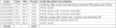
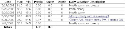
The weather the past two weeks has been quite uneventful here at OSNW3. The only quality precipitation came this past weekend. 0.62" fell over the two day span of Jun 27 - 28. Max temps have been close to perfect. A few humid days this past week with dew points in the low 60s on Jun 26. ( OSNW3 Observations | Jun 16 - 29, 2008) --- June 2008 is Wettest Month Ever in Oshkosh For the record OSNW3 measured 11.75" - Read the story from the NWS GRB

The 75 Year Storm

Image
Then the rains came. A whole months worth of precipitation fell in a matter of hours this past Thursday, along with the all-time max 24hr precipitation observation at OSNW3, again. It now stands at 5.32". Temperatures this past week were a bit below average, but nothing unbearable. We are currently averaging a max temp of 1.1° lower then last June through the first 15 days. ( OSNW3 Monthly Extremes ) ( OSNW3 Observations | Jun 9 - 15, 2008) ---- The 75 Year Storm In all of my 11 years living in Oshkosh I have never witnessed this kind of flooding. 50% of the homes in the city experienced some sort of flood damage totaling an estimated $13 million. The deluge was caught on video via the OSNW3 webcam. As you can see, the heaviest precipitation came during the hours of 5 and 6 o'clock. ( daily movie , photos , radar ) (OSNW3 - Jun 12, 2008) (The Lasky Estate - Jun 13, 2008)

Scootin'

Image
June is in full swing. Heat, humidity, and heavy rain. We witnessed the highest max temp of the season at OSNW3 on Saturday (86.4°), along with the largest 24hr precipitation observation for the month of June (1.14"). Plenty of thunder, lightning, and rain the past week (2.25"). Only eight full days in and already 61% of average precipitation (3.66") for the month has fallen. As I type, the back yard is flooded and the basement is wet once again due to the massive amounts of rain we are currently receiving. ( OSNW3 Monthly Extremes ) ( OSNW3 Observations | Jun 2 - 8, 2008) Addendum Monday mornings observation brought new observation records to OSNW3. Sundays precipitation total measured 3.51" making it the largest precipitation observation ever at OSNW3, bringing the monthly total for June to 5.76", 157% of average. ---- Adventure and Excitement As the week progressed I paid close attention to the weather near Minnesota's shoreline of Lake Superior. O

Rebound

Image
As soon as I mentioned that this May had been less erratic with temperature swings then last May, we witnessed a 37.8° drop overnight on May 26th. The daytime max surpassed the 80° mark for the first time in 232 days (Oct 8, 2007 - 80.6°) reaching 81.0° then dropped to 43.2° overnight. The swing downward rebounded as the week progressed and by weeks end we were actually experiencing some above average temps and some quality amounts of precipitation. The final burst wasn't enough to get us up to average for the month, but it did get us over 70% (2.10" of 2.96"). ( OSNW3 Observations | May 27 - Jun 1, 2008) The final max temperature comparison of May 2007 and May 2008 graph is below. This May averaged 4.1° cooler then last May.