Posts

Showing posts from October, 2012

October Rain & First 1 Inch Snowfalls

Image
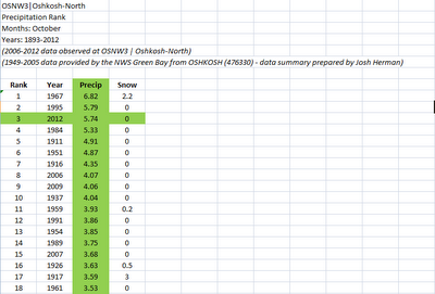
OSNW3 recorded 5.74 inches of precipitation this October which solidifies the third all-time greatest amount recorded in Oshkosh history for the month of October. Number two is 5.79 inches in 1995. The top spot belongs to 1967 when 6.82 inches fell. (click on image for entire data set - it will open a new tab/window) Oshkosh First 1" Snowfalls Since 1980, one may be hard pressed to remember when snow accumulated in Oshkosh more than an inch during late October into November. Off the top of my head, I could not remember what had happened in my own backyard. So I dug into it. Since 1980 the snow that fell at OSNW3 the days of Nov 9-10, 2011 is tied for the 4th earliest of all-time. It just so happens that back in 2006 two inches of snow fell in similar fashion on Nov 10-11. (click on image for entire data set - it will open a new tab/window)

September Climate Summary

Image
Autumn, my favorite season, accentuates Wisconsin's four season climate. Summer heat is pushed back down south. Days become shorter. A sense of calm sets in as a steady transition of soothing orange, red and yellows appear on the trees. The cool air outside currently cannot let us forget about the dozen beautiful days that preceded our first real taste of cold air this season. The warm, sunny days and cool, clear nights helped create the exceptional fall foliage we see this autumn. They are truly the best weather conditions for great colors. (Oct-4, 2012) September was an over achieving month. It recorded below average precipitation staking claim as a top 25 driest of all time. All of Winnebago County is currently in a Moderate Drought condition. September also recorded below average temperatures becoming the first month since September of 2011 to do so. OSNW3 September 2012 Daily Observations (click on graph for the month summary data - it will open a new tab/window)