Posts

Showing posts from October, 2009

October Top Ten Finish

Image
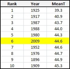
The last few days of October were no indication of what type of conditions prevailed for most of the month. Temperatures were down, and precipitation was up. Concluding the previous entry , October 2009 finishes in the top 10 for both the coolest and wettest of all-time. The active weather pattern of this October has got many thinking about what this Winter may have in store for snowfall. I am hoping for an above average season. See more details below... ( OSNW3 October Observations ) (OSNW3 October 2009 Summary) (click on graph for the complete month summary data - it will open a new tab/window) (OSNW3 Precipitation Through October 2009) (OSNW3 Misc Climate Happenings) Sunshine was scarce this October with only 19 Days with Sun and only one of those days were completely cloudless. We recorded 0 t-storms at OSNW3 in October which keeps our yearly total at 16. The monthly low temperature was overtaken this October at OSNW3 as the overnight low on Oct 11 dropped to 25.5° ( Monthl

Oshkosh's Top Ten Coolest Octobers

Image
Temperatures have been below average all around the Midwest so far this month, and because of it, regional NWS offices have been hard at work comparing this year to previous years. The NWS GRB ranked the top 5 coolest starts to October for Wausau, Green Bay, Appleton and Rhinelander. See data here . The NWS MKE ranked the top 10 coolest starts to October for Milwaukee and Madison. See data here . Neither of the offices reported on Oshkosh, so I felt it necessary to rank our top 10 coolest Octobers. After a few hours massaging the mother load of daily observations for Oshkosh since 1893 (see data here - 11M) I was able to parse out rankings of the mean temps for the month of October. Currently October of 2009 is the sixth coolest. The Rankings are listed below. (Oshkosh's Top Ten Coolest Octobers) Along with the rankings, I parsed out the actual daily observations from those years. Each of the years data tells a different story, but yet have one thing in common. It was chil

Chilly Start To October

Image
The first frost of the season came at a usual time (Sep 30), but the first freeze and first flakes made an early appearance, taking place this first full week of October. On Saturday the 10th the mercury dropped below 32° and the first flakes of the season fell. The flakes didn't last more than 15 minutes, but none the less they did fall. It was exciting to look out the window and see snow. However, this cool beginning sparks fearful thoughts of a mild, snow less December. ( OSNW3 October Observations ) (OSNW3 Oct 1 - 11, 2009 Summary) (click on graph for the entire data summary - it will open a new tab/window) ---- More On The Season Firsts The First Freeze of the season occurred October 10, 2009. The low temperature recorded was 28.5° around 7:30am. The temperature hasn't been that low since Apr 11, 2009 when it dipped to 28.8°, 183 days ago. The First Flakes of the season fell on October 10, 2009 as well. Last year they didn't fall until Oct 26, and two years ago we

Autumn Has Arrived

Image
October is beginning just as any Autumn fanatic, like myself, would have it begin. A lingering Low pressure system positioned over the Great Lakes keeping the weather cloudy, cool, and wet. Three out of the first four days of October saw accumulating rain with temperatures topping out below average. We had our first frost of the season the day before October started, but it was followed up with a light frost on Oct 1 ( Winter History - First & Lasts ). ( OSNW3 October Observations ) (Temp Comparison 2008 / 2009 | October 1 - 4) Max Avg: 57.6 / 57.2 / -0.4 Min Avg: 40.4 / 40.9 / +0.5 (October 2009 Precipitation | October 1 - 4) 2009 Monthly Total Precip.. 0.58" Snow.... 0.0" Oshkosh Average Precip.. 2.20" Snow.... 0.1" Departure Precip.. -1.62" Snow.... -0.1" ---- Millers Bay I had a few extra minutes to spare on Oct 4, so I took a bike ride over to Millers Bay. I snapped the usual photos to merge into a panoramic. The dock was jam packed with