Posts

Showing posts from January, 2009

Below Average

Image
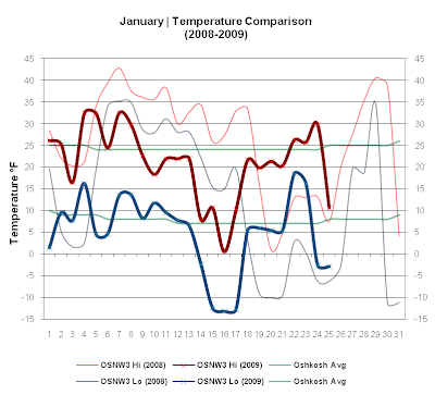
It's been a dry January thus far. One day this past week saw accumulating snow. It was light only adding up to 0.1". The week wasn't a total washout, however, as on 5 of the 7 days we did see snowflakes or a trace of precip. We are currently 7" below the monthly snowfall average and 0.77" below the monthly precipitation average. There is a week left of the month. Perhaps we'll get there, but it doesn't look good. As for temperatures, we've been hovering around seasonable. ( OSNW3 January Observations ) (Temp Comparison 2008 / 2009 | Jan 1 - 25) Max temp: 25.6 / 21.2 / -4.4 Min temp: 13.3 / 4.9 / -8.4 (January 2009 Precipitation) 2009 Monthly Total Precip.. 0.58" Snow.... 5.5" Oshkosh Average Precip.. 1.35" Snow.... 12.4" Departure Precip.. (0.77") Snow.... (7.0") ---- Freezing Fog We had our hand dealt with freezing fog the morning of Jan 23. It was minimal, but none the less, Oshkosh was coated. Some not so goo

An Arctic Outbreak

Image
This past week, we here at OSNW3 experienced the coldest air of the season. An Arctic outbreak occurred for 4 straight days. More details on the outbreak are below. Precipitation wise, we were quite dry, even though it precipitated on 5 of 7 days. Already, this January has as many Days with Measurable Snow as last January. However, the amount of snowfall this January is much lower then last, as last January saw 23.3" fall in 10 total days and this January only 5.3" in 10 total days. An 18" difference. ( OSNW3 January Observations ) (Temp Comparison 2008 / 2009 | Jan 1 - 18) Max temp: 31.8 / 20.9 / -10.9 Min temp: 20.6 / 4.4 / -16.2 (January 2009 Precipitation) 2009 Monthly Total Precip.. 0.57" Snow.... 5.3" Oshkosh Average Precip.. 1.35" Snow.... 12.4" Departure Precip.. (0.78") Snow.... (7.1") ---- Snowfall The snow that fell this week was very light once again. We here at OSNW3 have given up on relying on any snowfall forecast f

Snowstorm Deprivation Syndrome

Image
SDS! Dewdrop said I could say it, and so... the insignificance continues. We had many forecasts of moderate accumulations, but in the end received just above a Trace on each occasion. At least the temperatures remained below freezing for most of the week (unlike last year). I am looking forward to the cold snap and the possible accumulating snow a few clippers may bring. It's a great time of year, get out there and enjoy it! ( OSNW3 January Observations ) (Temp Comparison 2008 / 2009 | Jan 1 - 11) Max temp: 32.3 / 25.6 / -6.7 Min temp: 21.8 / 9.1 / -12.7 (January 2009 Precipitation) 2009 Monthly Total Precip 0.31" Snow 1.2" Oshkosh Average Precip 1.35" Snow 12.4" Departure Precip (1.04") Snow (11.2") ---- Snowfall The snow that fell this week was very light. A clipper was forecast to bring up to 4" to Oshkosh on Jan 9, but the system dove south and just clipped us on it's north side. (Jan 8-11, 2009 us radar loop ). After the clipper

It's a New Year

Image
This past week was kinda insignificant once the year rolled over. OSNW3 measured 35.6" of snowfall in December which kept us very busy around here. More info on December's snowfall can be found here . January has been a different story so far with the year coming in almost exactly how it did last year. Measured the same amount of snow on the same day, a whopping 0.2" on Jan 2, and measured the same depth of snow, 8". The difference being that the forecast is not calling for a major warm-up as we experienced the early part of Jan 2008 when the temp rose above freezing for seven days in a row (Jan 6-11) topping out at 42.8° on Jan 7. Back to this year. Freezing rain did make an appearance on Saturday, Jan 3 as OSNW3 measured 0.14" of liquid with an ice coating of 0.1" on everything outdoors. Here's to more snow this season, hopefully... CHEERS! ( OSNW3 January Observations ) (Temp Comparison 2008 / 2009 | Jan 1 - 4) Max temp: 28.3 / 25.7 / -2.6 M

December Snowfall - 2008

Image
Oshkosh experienced a record snowfall during the month of December 2008 (More info on that as the NWS GRB releases it) . OSNW3 saw accumulating snows on 18 of the 31 days, with Dec 20-21 recording the largest 24hr accumulation of 5.1". (OSNW3 December Snow/Precip Days) ---- (OSNW3 Snowfall Comparison - December) ---- (Oshkosh Precipitation Observer Comparison) The link below is a Google Earth tour displaying each observer station location along with it's December snowfall total. In Google Earth, click on the snowflake for more information about the station. (Data provided by National Weather Service and CoCoRaHS cooperative observer program volunteers) WI_WINNEBAGO_PRECIP_OBSERVER_STATIONS ---- (OSNW3 Snowfall Comparison Through December) ---- (Temp Comparison 2007 / 2008 | Dec 1 - 31) Max temp: 28.3 / 25.9 / -2.4 Min temp: 15.7 / 8.1 / -7.6 ---- For more detailed information on OSNW3 data follow the links below. Daily Observations Annual Precipitation Seasonal Snowfal