Posts

Showing posts from September, 2008

Similar Endings

Image
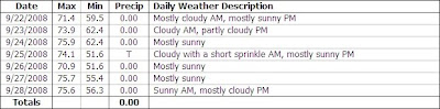
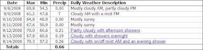
Another Summer like week, this past week, with above average temperatures and plentiful sunshine. The past nine days have seen max temps above 70. The temperature graph, below, comparing this September with last September concludes that both months ended quite similar. It's an interesting graph, showing a similar sine wave with this September being a bit less dramatic. One difference is, however, no frost occurred this September... but, the second coolest reading this month (48.0°, coolest reading 47.8° on Sep 9) did come on the same day as the first frost & coolest reading in September 2007 (39.4°), Sep 15. To date the overall max temp comparison, 71.4/71.3 (-0.01) and overall min temp comparison, 55.8/56.1 (+0.03), are very similar as well. Overall precipitation is at 37% of average (1.29 of 3.47). It's been a very dry September. ( OSNW3 Observations | Sep 22 - 28, 2008) ---- Color Report Leaves are changing slowly here at OSNW3. A few more patches of color have sp

Sunshine

Image
After the rain & clouds from last weekend moved out, a sunshine filled week graced the Oshkosh area. This past week went mainly cloudless until late Saturday when a cold front moved through. The front brought only a Trace of precip to OSNW3. Weather conditions have been absolutely perfect for mid September. Last week max temperatures were steady, hovering at or above average. Currently, this September, max temperatures are averaging 0.8° below last September (71.2 / 70.4). Min temperatures were above average this past week as they only dropped into the upper 50s for the most part. ( OSNW3 Observations | Sep 15 - 21, 2008) ---- Fall Color Report Leaves are changing slowly here at OSNW3. A few patches of color around the area, but we remain mainly green. Keep up on the latest state wide color changes from Travel Wisconsin Fall Color Report . (Tree Across Street - Sep 21, 2008) (Tree Out Back - Sep 21, 2008)

Autumn Is In The Air

Image
Thoughts of Autumn came to mind as the past three days have been cloudy with rains totaling 0.66". Saturday's precipitation fell as a heavy mist mainly, but a brief moderate shower later in the day brought the highest accumulation of the three days (0.26"). Max temperatures have been below average the entire week, and to date are averaging 3° below last September (73.6/70.6). Minimum temperatures, on the other hand, have fluctuated as the overnight low on Sep 9 dipped into the 40's (47.8°) for the first time in 103 days (May 30th when it was 49.3°) and then on Sep 12 only making it down to 60.6° as warm and humid air moved through with the precipitation. The graph below depicts the fluctuation. ( OSNW3 Observations | Sep 8 - 14, 2008) ---- Fall Color Report Not much changing here at OSNW3. Only a few branches are starting to loose their green leaf color. Derek, over at NW Wisconsin Weather , discusses his areas first signs of fall color in his Septemb

Hurricane Rain

Image
Remnants of Hurricane Gustav moved through this past Thursday. OSNW3 received 0.54" from Gustav. It was a much needed slow and steady rain. The day felt like a mid Spring or Autumn day as the daytime max temperature stayed below 60°. Official max temperature at OSNW3 was 59.5°, the lowest max temp since Jun 3 when the temp maxed out at 58.1°. OSNW3 has received 17% of average precipitation so far this September (0.58" of 3.47") and the max and min temperatures are averaging about 6° below last September, to this date (Max: 79.9/73.9, Min: 66.1/59.4). ( OSNW3 Observations | Sep 1 - 7, 2008) ---- Tropical Storms (US landfall) Hanna radar loop . (3Mb) Gustav radar loop . (6Mb) Fay radar loop . (7Mb) ---- Cloud Appreciation As I was traveling east towards Sheboygan, WI on Wednesday I noticed what may be a cloud I've never witnessed before in person. The old Kelvin-Helmholtz wave cloud. Look very closely and be the judge. It's in the middle of each photo. Cl