Posts

Showing posts from June, 2009

Summer Has Arrived

Image
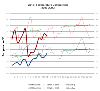
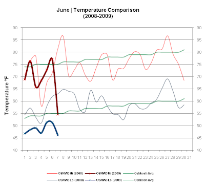
The first two weeks of June in 2009 have been cool. So cool that since 2000 no first two weeks of June have been this cool. Is it an official record? I do not know, but I'd like to find out. As for Summer arriving, it indeed has. Max temperatures are above 70 and as far out as I am willing to believe a forecast, things will stay this way. The cool start is now history. This past week brought some drenching rains early, nearing the 2" by the week end which is keeping us well saturated thus far. ( OSNW3 June Observations ) (Temp Comparison 2008 / 2009 | June 1 - 14) Max Avg: 73.0 / 67.4 / -5.6 Min Avg: 59.1 / 51.1 / -8.0 (June 2009 Precipitation | June 1 - 14) 2009 Monthly Total Precip.. 2.39" Oshkosh Average Precip.. 3.66" Departure Precip.. -1.27" ---- A Record Cool Start Here at OSNW3, the first two weeks of June in 2009 have been the coolest on record. Data recording began at OSNW3 in November of 2006. Comparing the first two weeks of the first two

The Oshkosh Derecho - June 11, 2001

Image
In honor of Mother Nature, I have provided many informational links to what went down this day in Oshkosh's history. After such, is my deteriorating memory and other memories from friends who were around Oshkosh that day. Severe Thunderstorms in East-Central Wisconsin During the late evening of June 11, 2001, a large thunderstorm complex (which included a bow echo and subsequent "bookend vortex") moved across central and east-central Wisconsin. Winds exceeded 70 mph across the area, resulting in thousands of downed trees and damage to homes and businesses More ... Storm Surge On Lake Butte Des Morts The storm passed over several shallow lakes including Lake Butte des Morts near Oshkosh, WI creating a storm surge. More ... Packerland Weather News The comma head of the derecho is sometimes associated with hurricane-like conditions. More ... (Page 4) City Of Oshkosh Emergency Government Operations The Damage Assessment Teams also finished their initial

A Cool Start To June

Image
The heat is on... inside the house. Temperatures were seasonable for the most part this past week with a weekly max of 77.0°, but no more then 12 hours after that reading the temperature fell 25° and then didn't move much the following day. Currently as I type this (15:30-Jun 7), the temp stands at 56.7° threatening yet another low max daily temperature record. Precipitation was light early in the week, but as the week came to an end a system pushed through dropping nearly a half inch of rain. Foliage is thick around here and it's getting close to my favorite part of Summer, when everything is at it's peak green. ( OSNW3 June Observations ) (Temp Comparison 2008 / 2009 | June 1 - 7) Max Avg: 72.0 / 69.1 / -2.9 Min Avg: 57.0 / 48.6 / -8.4 (June 2009 Precipitation | June 1 - 7) 2009 Monthly Total Precip.. 0.45" Oshkosh Average Precip.. 3.66" Departure Precip.. -3.21" ---- Record Low Max Broken? On June 6, 2009 OSNW3's recorded max temperature for the 2