Posts

Showing posts from December, 2009

It's Dark Outside

Image
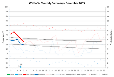
Max temperatures hovered around average for the most part this past week. With the warmer temps, though, we did see four measurable snowfalls. Nothing major as three of the four were under an inch. We are currently 4.2" above the December monthly snowfall average and for the third consecutive year have exceeded that average. Last December Oshkosh broke an all-time monthly snowfall record, recording 35.6" here at OSNW3 and 33.7" officially at the WWTP. An amazing 18 days recorded measurable snowfall ( Days with Measurable Snowfall ), and comparing last December to this December we are two days behind. Up to this point, last December had 10 days with measurable snowfall while this December has had only 8, which is still above the Oshkosh average (6.1 days). ( OSNW3 December Observations ) (OSNW3 December 2009 Summary) (click on graph for the month summary data - it will open a new tab/window) ---- Weekly Snowfall Each of the four snowfalls last week provided just en

December's Big Hand

Image
We have to give a big hand to the 12 beginning days of December 2009. In these 12 days we here at OSNW3 have experienced a plethora of seasonal firsts. First accumulation (Dec 3), first inch (Dec 7), our first snowstorm and the first day of winter (Dec 12) have all taken place. The first snowfalls came a week or two late, but the first snowstorm and winter were near "normal" according to archived data observed at OSNW3 ( Firsts & Lasts ). ( OSNW3 December Observations ) (OSNW3 December 2009 Summary) (click on graph for the month summary data - it will open a new tab/window) ---- Weekly Snowfall The past week was an exciting one for snowfall. The beginning of the week we were still wishing for snow. As of today we've got a fairly fresh base, seven inches deep. As for what is to come next in Oshkosh, follow these guys ( Tim , Derek , & Chris ) and you'll have an idea of the days ahead. If what they're reporting sparks an interest then check the OSNW3

Snowstorm - Dec 8-9, 2009

Image
Here comes Winter. The coldest air of the season is about to ride in on the heels of a top 5 snowstorm for many around the region. The storm proved to be what it was hyped up to be. The Wovel got a solid work out removing the almost 10" of fresh snow. It was heavy in most places and without fluff. I measured six times throughout the storm totaling 9.8". Each of the observations are listed below. For more on the storm from the NWS Green Bay and the NWS Milwaukee/Sullivan please click the links. Two photos of the aftermath along with the storms duration webcam video (4MB). Radar loops of each day can be found here by clicking on the linked "Daily Weather Description". Pretty fun stuff. (Front Of House - Dec 9, 2009) (Back Of House - Dec 9, 2009) ---- Measurements (6) ---- Dec 9, 2009 @ 9:41am Blowing snow. The winds have picked up considerably since the last observation. Starting to drift in the driveway. Radar indicates a diminishing snowf

Welcome December

Image
December is upon us and things are becoming interesting. Many forecasters are currently predicting the first major winter storm to affect the area early next week (Tue/Wed). All the while, it seems like forever since the last time the high temperature even stayed below freezing. It has been quite an extent of days, 266 consecutive days as a matter of fact, ending on Dec 4 as the temperature maxed out at 26.0°. Once the temperature tumbled, it allowed the seasons first accumulation of snow to occur. It was nice to see the white stuff once again. Last year at this time we had 5" on the ground. ( OSNW3 December Observations ) (OSNW3 December 2009 Summary) (click on graph for the month summary data - it will open a new tab/window) ---- First Accumulation The 2009-2010 winter seasons first accumulating snowfall took place during the day on Dec 3, 2009 ( First & Lasts ). It was somewhat unexpected as most forecasts kept accumulating snow out of the question 24 hours prior. The

Snow!

Image
Nope, not here in Oshkosh, But in the Dallas, TX area. Seems the Dallas area received a measurable snowfall before Northeast WI this year. A good friend of ours who lives in Dallas reported early this morning that it was snowing. Below is his photo. His photo doesn't show any accumulation and it is hard to pick out the flakes, but in the distance it sure looks like it is snowing. I believe him. Also, below is a snapshot of a webcam in the Fort Worth area with some definite accumulation on the grass. (Dallas, TX area - Dec 2, 2009) (photo courtesy of Brett Eifler) (Fort Worth, TX area - Dec 2, 2009) (photo courtesy of WXnation.com ) (Regional radarloop) (click on radar for a larger image) ---- Fun Satellite Images Last night I was surfing the WisconsinView site satellite images. I came across three that stood out to me. Below are descriptions of each. - First is the day prior to the ice shoves on Lake Winnebago. The ice on the lake is noticeably cracked and separated. Not