Spring Has Arrived
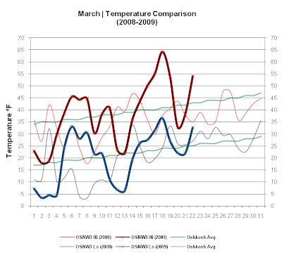
This past week was warm, relatively speaking. Four consecutive days saw max temps 50° or above. Mar 17 had the third highest max temp ever recorded at OSNW3 in the month of March, topping out at 64.2°. We also saw the season transition from Winter to Spring this past week which in the end brought an accumulating snowfall on the first day of Spring. (OSNW3 March Observations)
(Temp Comparison 2008 / 2009 | March 1 - 22)
Max temp: 34.2 / 38.3 / +4.2
Min temp: 18.4 / 20.3 / +1.9
(March 2009 Precipitation)
2009 Monthly Total
Precip.. 1.54"
Snow.... 7.6"
Oshkosh Average
Precip.. 2.18"
Snow.... 7.6"
Departure
Precip.. (0.64")
Snow.... +0.0"

----
Snowfall Mar 21
Winter delivered a goodbye snowfall
(1.0" measured @ 1:38am on Mar 21 - Total 1.0")
(radar loop / daily video)


----
Winter Duration
Winter ended at OSNW3 the same day as Spring began astronomically, Mar 20, 2009. According to the Winter Duration formulas here at OSNW3, Winter began on Dec 10, 2008 and ended on Mar 20, 2009 for a total of 100 days. As Spring takes hold, the Firsts & Lasts data for this Winter season will become complete.
(Winter Season Duration 2008-2009)

(OSNW3 - Mar 10-18, 2009)

----
Climate Research
With my recent "Data Bounty" I started a couple projects of climate research. Two of them are explained below.
--Below Zero Temperatures
As this Winter comes to an end for most of us, I would like to remember the most recent cold snap. Timothy, Nathan (see his cbox), Derek, and Dirk followed the chilly air as some of the coldest readings took place in their areas. With the cold air hanging around a few days I was inspired to search out consecutive streaks of below zero readings for my area.
(Consecutive Days)
OSNW3 Oshkosh-North (6)
OKHW3 Oshkosh-WWTP (19) *official nws data for oshkosh
(OSNW3 - Days with Min Temp Below Zero)

--Maximum Snowdepth
In the data for OKHW3 Oshkosh-WWTP, consecutive days with temps below zero, there is a date that stands out to me. Feb 13, 1936 as it has a reported snowdepth of 28" (it's highlighted in yellow). Listed below are the highest daily snow depths from the official COOP station for Oshkosh, OKHW3 Oshkosh-WWTP, dating back to 1902. (I obtained the numbers by using the NOWData portion of the Climate index on the NWS GRB site)
OSHKOSH (476330)
Extremes
Highest Daily Snow Depth (inches)
Days: 1/1 - 12/31
Length of period: 1 day
Years: 1902-2006
Rank - Value - Ending Date
1 - 30" - 2/3/1971, 2/2/1971
3 - 29" - 2/4/1971
4 - 28" - 2/16/1979, 2/15/1979, 1/28/1979-1/24/1979
Only periods with no missing data were evaluated.
Last value also occurred in one or more previous years.
The deepest snowdepth I've measured here at OSNW3 is 16" on Feb 19, 2008 (photo). I know Nathan had some deep snow pack up on Maple Hill this season, 23.1" on Jan 20! See his blog entry for more details.
----
Front Of House
It's Spring! AND, if you live in Oshkosh make sure to vote YES! :)
(FOH - Mar 22, 2009)

(Temp Comparison 2008 / 2009 | March 1 - 22)
Max temp: 34.2 / 38.3 / +4.2
Min temp: 18.4 / 20.3 / +1.9

(March 2009 Precipitation)
2009 Monthly Total
Precip.. 1.54"
Snow.... 7.6"
Oshkosh Average
Precip.. 2.18"
Snow.... 7.6"
Departure
Precip.. (0.64")
Snow.... +0.0"

----
Snowfall Mar 21
Winter delivered a goodbye snowfall
(1.0" measured @ 1:38am on Mar 21 - Total 1.0")
(radar loop / daily video)


----
Winter Duration
Winter ended at OSNW3 the same day as Spring began astronomically, Mar 20, 2009. According to the Winter Duration formulas here at OSNW3, Winter began on Dec 10, 2008 and ended on Mar 20, 2009 for a total of 100 days. As Spring takes hold, the Firsts & Lasts data for this Winter season will become complete.
(Winter Season Duration 2008-2009)

(OSNW3 - Mar 10-18, 2009)
----
Climate Research
With my recent "Data Bounty" I started a couple projects of climate research. Two of them are explained below.
--Below Zero Temperatures
As this Winter comes to an end for most of us, I would like to remember the most recent cold snap. Timothy, Nathan (see his cbox), Derek, and Dirk followed the chilly air as some of the coldest readings took place in their areas. With the cold air hanging around a few days I was inspired to search out consecutive streaks of below zero readings for my area.
(Consecutive Days)
OSNW3 Oshkosh-North (6)
OKHW3 Oshkosh-WWTP (19) *official nws data for oshkosh
(OSNW3 - Days with Min Temp Below Zero)

--Maximum Snowdepth
In the data for OKHW3 Oshkosh-WWTP, consecutive days with temps below zero, there is a date that stands out to me. Feb 13, 1936 as it has a reported snowdepth of 28" (it's highlighted in yellow). Listed below are the highest daily snow depths from the official COOP station for Oshkosh, OKHW3 Oshkosh-WWTP, dating back to 1902. (I obtained the numbers by using the NOWData portion of the Climate index on the NWS GRB site)
OSHKOSH (476330)
Extremes
Highest Daily Snow Depth (inches)
Days: 1/1 - 12/31
Length of period: 1 day
Years: 1902-2006
Rank - Value - Ending Date
1 - 30" - 2/3/1971, 2/2/1971
3 - 29" - 2/4/1971
4 - 28" - 2/16/1979, 2/15/1979, 1/28/1979-1/24/1979
Only periods with no missing data were evaluated.
Last value also occurred in one or more previous years.
The deepest snowdepth I've measured here at OSNW3 is 16" on Feb 19, 2008 (photo). I know Nathan had some deep snow pack up on Maple Hill this season, 23.1" on Jan 20! See his blog entry for more details.
----
Front Of House
It's Spring! AND, if you live in Oshkosh make sure to vote YES! :)
(FOH - Mar 22, 2009)

No problem man, thanks! Yea I would say this ice storm is quite localized, just affecting the Northeast corner of Minnesota. I'm hoping for some thunder up here on Tuesday. Quite the storm! I love transition seasons!
ReplyDeleteIt seems we may get a good dose of rain Tue-Wed. Snow storm this weekend?! :)
ReplyDeleteOSNW3, I'll bet you're chompin at the bit to get all your newly acquired climate data analyzed and plugged into your data system. I have spring break during the latter part of this week, and your new post has given me some motivation to wrap up my winter data for this station.
ReplyDelete100 days in winter...is that normal for you? Also, what formula do you use to find the beginning/end of your winter? I'd be interested to do the same for this area.
Enjoy your rain.
Where did all the s#@w go?
ReplyDeleteWxWatcher, I am and there is just so much there. It's wonderful. The reason I asked for the data is that I am researching the old weather maps to determine if a snowfall was a Clipper or Colorado low... etc. The past two seasons rank in the top 5 of snowiest back to back years... I want to look back on each of those top 5 periods and determine what type of systems brought the snow. I wanted a reference on which days it snowed, hence the data (to make it easier). It's a daunting task, but I am up to. I am pretty certain I will learn many things from this even though the reason I am doing it may be ridiculous. HA. :)
ReplyDeleteI am happy to have been a muse. I am very interested in you Winter data. I hope you get the time!
About the Winter Duration stuff. If you go back into this blog entry, scroll down to the "Winter Duration" title (bold text) and then click on the linked text "Winter Duration" it'll bring you to a page with a definition. (or just click here). It's something Nathan and I came up with a couple years back. The definition criteria for my backyard may differ from your backyard. As a matter of fact, I am 100% positive it will. I am very interested in what you come up with for your definition! :)
I've only had 3 seasons of my own data to run in the formula... but now with the Oshkosh data I just acquired, I could make many more seasonal runs! Now you've been my muse! Thanks!
Dew, it melted. ;)
ReplyDeleteOSNW3,
ReplyDeleteIt looks like we may get a spring snow! Keep an eye on Missouri's storm...we may get some interesting snowfall amounts with some wicked banding on Saturday.
You look due for some of the same system, as well!
WxWatcher, I'll be watching with high interest! Hmm, I have an idea...
ReplyDeleteYea I noticed that the NWS in Duluth was forecasting lows around or below zero for Friday Night, I know some spots (traditional cold areas) up in N. MN. did drop below zero This Morning, but here in Duluth it stayed between 15-20, thanks to an east wind, lake clouds, and flurries thru the night. That's fine with me, I like the snow, but dislike extreme cold..lol.. You getting any snow from that storm coming NE Tonight? Or is it staying south of your area?
ReplyDelete