Posts

Showing posts from November, 2008

First Accumulation

Image
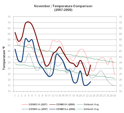
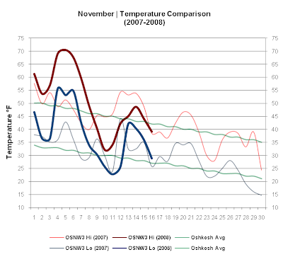
This past week max temps remained below average each day. Along with the cool temps came OSNW3's first accumulating snow however. It was only a tenth of an inch, but none the less ( daily video ). The large Lake Effect events that dumped several inches in the UP and Northern WI only ushered in clouds and maybe a flurry from time to time for us down here as we remained mainly sunny and windy. ( OSNW3 November Observations ) (Temp Comparison 2007 / 2008 | Nov 1 - 23) Max temp: 45.9 / 45.1 / -0.7 Min temp: 32.7 / 32.7 / +0.0 (November 2008 Precipitation) 2008 Monthly Total Precip 0.87 Snow 0.1 Oshkosh Average Precip 2.51 Snow 4.0 Departure Precip (1.64) Snow (3.9) ---- Monday, Nov 17 I witnessed about a half inch of snow accumulate from a short lived snow squall. Start to finish the squall lasted about 30 minutes. I was fortunate enough to have the time to document my first taste of Winter weather this season. Photo and video below. (Neenah, WI - Nov 17, 2008) (Neenah, WI - No

November Is Here

Image
This past week OSNW3 experienced some "typical" November weather. The daily temps traversed like a roller coaster and 4 out of 7 days saw measurable liquid precipitation. The 24 hour period ending Nov 14 recorded 0.33" of rain ( radar loop ) with a max temp just short of 50, while the max temp on Nov 10 struggled to break the freezing point. ( OSNW3 November Observations ) (Temp Comparison 2007 / 2008 | Nov 1 - 16) Max temp: 48.5 / 50.8 / +2.4 Min temp: 33.9 / 38.2 / +4.3 (November 2008 Precipitation) 2008 Monthly Total Precip 0.86 Snow 0.0 Oshkosh Average Precip 2.51 Snow 4.0 Departure Precip (1.65) Snow (4.0) ---- Front Of House Due to the front of the house not changing it's look much this past week I thought I would venture out and take a photo of something else. On my bike ride home after a ripping Packers victory I paused for a moment to take in the scenery. Below is a loosely put together panoramic view looking northwest down the Fox River from the Oshk

Ups and Downs

Image
Most of the area broke all time max temperature records early this past week. Mega warmth for November as OSNW3 recorded a max temp of 70.5 on Nov 4th. The day before and after had max temps in the upper 60's. It felt like Summer, but sure didn't look like it as most of the trees are bare with leaves covering the ground. As the week progressed colder air moved in on the backside of a strong low pressure system ( radar loop ) which got us back to feeling November-ish. The temp on Nov 8 barely broke 40 maxing out at 40.5. ( OSNW3 November Observations ) (Temp Comparison 2007 / 2008 | Nov 1 - 9) Max temp: 48.5 / 58.7 / +10.2 Min temp: 35.5 / 43.3 / +7.8 (November 2008 Precipitation) 2008 Monthly Total Precip 0.31 Snow 0.0 Oshkosh Average Precip 2.51 Snow 4.0 Departure Precip (2.20) Snow (4.0) ---- Snow OSNW3 almost saw the first measurable snowfall of the season, but not quite, just below 0.1" so only a Trace was recorded Nov 8. It did lightly snow throughout the d

New Edition

Image
The potential first flakes of the 2008/2009 Winter season were a focus in last weeks forecast. Great anticipation for the white stuff ensued, as last season OSNW3 didn't record the first flakes until Nov 8. The system to affect the region starting last Sunday looked ominous during the middle of the previous week. I was anxious to watch it evolve. OSNW3 did indeed see the first flakes of the season on Oct 26 and after watching the daily video from the day, it was confirmed. An unrecorded event happened on Oct 26, as well, when the max temp didn't break 50. The max temp hadn't remained below 50 since way back on Apr 28 when it only reached 43.0. 182 day duration. OSNW3 recorded the first freeze on Oct 29 as the temperature dipped to 30.2 during the early morning hours as the sun was rising. ( Frists & Lasts ) ( OSNW3 October Observations ) (Temp Comparison 2007 / 2008 | Oct 1 - 31) Max temp: 62.5 / 57.2 / -5.3 Min temp: 49.2 / 41.8 / -7.3 (October 2008 Precipita