Posts

Showing posts from December, 2007

Wanning Snow Pack

Image
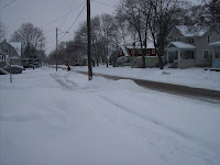
It's something I did not want to read, but it's there, in all the Forecast Discussions, that the dreadful "start of the year warm up" is approaching. We experienced it last year as well, seven days in a row to start the year off with high temps above 40F. We've had a great December receiving 22.5" of snow and currently as I blog, a snowdepth of 8". O'l Congress Avenue looks Wintry right now, but will not stay that way unfortunately. Take a look for yourself at how Spring like the beginning of January 2007 was. Happy New Year!

Winter Solstice

Forecasts were for a Winter storm to impact the area as the official day of Winter approached. Predictions of where the rain/snow line would be positioned were in question and I was crossing my fingers that we'd be on the snow side the entire time. Not to be. It rained the entire day and night on Saturday, Dec 22. OSNW3 measured 1.02" of rainfall as the precipitation changed from rain to snow around 6am on Sunday, Dec 23. The temperatures dropped rapidly from the mid 30's to the mid teens as the cold air rushed in. The winds picked up and the snow finally showed it's face! Winter Solstice weekend storm photos . Winter Solstice weekend storm radar loop .

Midwest Snow

Image
We arrived in St. Louis just after 11pm on Friday night. The snow started to fall shortly after. We awoke to just under 2". It was a wet, heavy snow. As the day progressed the temp hovered around freezing not allowing the snow to accumulate much, but once night fell, and the temp dropped, this all changed. St. Louis received an official total of 7". It was nice to have the snow follow us, so to speak. It's not often St. Louis gets a snowfall of this magnitude. It was a treat to experience a snowstorm down there... Photos from the weekend are here .

OSNW3 IS BLOGGING

There is much more to view of OSNW3 | OSHKOSH-NORTH by clicking here!