Posts

Showing posts from April, 2009

Aprils Rollercoaster Ride

Image
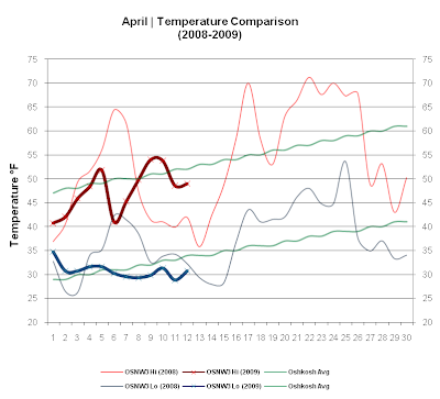
This past week we saw measurable precipitation each day with one of the days even seeing measurable snow. Temperatures started out quite a bit below average but slowly worked their way back and by the end of the week shot through the roof. They spiked for one day, Apr 24, as the temp rose to 79.7° with dewpoints topping 60°. No sooner then the spike, they fell back to below average once again. The roller coaster ride that is April has been an exciting one this second half of the month in 2009. ( OSNW3 April Observations ) (Temp Comparison 2008 / 2009 | April 1 - 26) Max temp: 54.3 / 52.8 / -1.5 Min temp: 37.5 / 34.5 / -2.9 (April 2009 Precipitation | April 1 - 26) 2009 Monthly Total Precip.. 2.74" Snow.... 0.1" Oshkosh Average Precip.. 2.87" Snow.... 1.5" Departure Precip.. -0.13" Snow.... -1.4" ---- Days Above 60° Continued Continuing the graph for "Days Above 60" we can see that the warm temperatures of last weekend didn't last long. O

April Growth

Image
The warmth finally broke. Temperatures soared into the 70s late this past week and... overnight, Apr 18-19, some liquid actually fell from the sky. It's been dry around here lately so it was nice to see the ground moist again. ( OSNW3 April Observations ) (Temp Comparison 2008 / 2009 | April 1 - 19) Max temp: 49.4 / 52.4 / +3.0 Min temp: 34.6 / 33.1 / -1.5 (April 2009 Precipitation | April 1 - 19) 2009 Monthly Total Precip.. 0.26" Snow.... 0.0" Oshkosh Average Precip.. 2.87" Snow.... 1.5" Departure Precip.. -2.61" Snow.... -1.5" ---- Days Above 60° As the season changes in and out of Winter here in WI, days with temperatures above 60° are few and far between. Through Apr 19, 2009 we here at OSNW3 have recorded 19 days since Oct 1, 2008. Each Spring when we experience consecutive days above 60 most everyone becomes active and gets into "summer" mode. The sounds of tillers, chain saws, and rakes can be heard all through out this block o

April Musing

Image
The sun shone and the wind whipped, this past week. Persistent NNW winds held maximum temperatures down, but overall it was a pleasant week. No precipitation fell and we had plentiful sunshine each day. ( OSNW3 April Observations ) (Temp Comparison 2008 / 2009 | April 1 - 12) Max temp: 47.7 / 47.5 / -0.2 Min temp: 34.1 / 30.7 / -3.4 (April 2009 Precipitation | April 1 - 12) 2009 Monthly Total Precip.. 0.24" Snow.... 0.0" Oshkosh Average Precip.. 2.87" Snow.... 1.5" Departure Precip.. -2.63" Snow.... -1.5" ---- The Second Week of April Nathan brought up the famed " April 10th storm " from last year and instantly I wanted to see the radar. Sure enough. Impressive radar returns with 2008 and even 2007. Seems we here in the North have been spared in 2009, but places to our south have not. The second week of April is truly an active part of the year, well at least during 2007-2009. (click images for radar loop) (Radar from Apr 11, 2007) (Rada

Days of April

Image
There were a few systems that rolled through this past week, but only one made an impact here at OSNW3. One day with rain and wind proved to be the highlight of the week. Temps for the most part were below average, but by no means cold. We spent a good amount of time outdoors taking walks and such. ( OSNW3 April Observations ) (Temp Comparison 2008 / 2009 | April 1 - 5) Max temp: 46.9 / 45.8 / -1.1 Min temp: 30.9 / 31.9 / +1.0 (April 2009 Precipitation | April 1 - 5) 2009 Monthly Total Precip.. 0.24" Snow.... 0.0" Oshkosh Average Precip.. 2.87" Snow.... 1.5" Departure Precip.. -2.63" Snow.... -1.5" ---- Waves & Ice Shoves As the storm system moved through the area on Mar 31, with it came some powerful southeast winds. Enough to stir up the Sheboygan shoreline of Lake Michigan and to push the Lake Winnebago ice onto the shoreline in Oshksoh. In some places almost as high as the houses. Wind gusts (data from Mike Davey ) were almost 30mph. ( rada