Posts

Spring Fever, The Next Cold Snap, Winter Fish Kill & March Madness

Image
Spring fever is in full bloom. I've been stricken with the fever, but I will admit I am not ready. This feeling leaves me with some sort of yard clean up anxiety that I cannot completely comprehend. Maybe it's the fact that I just don't want to give up the snugness my winter hat gives me. Regardless, temperatures for the month of March thus far are way above average as one would expect, 7.4 degrees above the mean average (81-10) to be exact. Based on the temperature trend projected by Lezak's Recurring Cycle theory , this warmer than average trend should last until the end of the month when a few shots of colder air are likely. ( OSNW3 Weather Brief ) ( OSNW3 March Observations ) (OSNW3 March 2012 Summary) (click on graph for the month summary data - it will open a new tab/window) ---- These warm March conditions are emitting a false sense of season and the longevity of them allow me ample time to ponder the next potential cold snap. Following the tempe...

Early March Ice Shoves & An Oshkosh Then and Now Photo

Image
The first winter storm warning of the season was issued on Mar 2.  The storm was worthy of the warning and it reminded me how much I enjoy a snowstorm.  It is something that has been severely lacking in 2011-12 winter season. More on the storm can be found here . A little over two weeks ago I posted preliminary meteorological winter statistics.  I have now updated the numbers and they can be found here . Overall the numbers kept moving in the direction they were headed. Winter was abnormally warm and lacking in snowfall. Spring weather is just around the corner. Following the LRC and the trend it provides for temperature and precipitation, Oshkosh should be fully entrenched in spring by the end of March.  For a look at the trends please click here . Stay on top of the weather that is happening now by visiting the OSNW3 weather brief linked below. ( OSNW3 Weather Brief ) ( OSNW3 March Observations ) (OSNW3 March 2012 Summary) (click o...

2011-12 Meteorological Winter Statistics

Image
This is certainly the fun part that comes along with having the archived historical daily weather data for Oshkosh! The data archive goes back to 1894. This winter has claimed a spot the history books! Recognizing the significance of this winters behaviors in categories of mean temperature and the amount of days with maximum temperatures above freezing is crucial. Adding snowfall total and days with measurable snowfall to the comparison the 2011-12 winter becomes one for the ages. Please click the link below for the complete set of rankings (to see each category please scroll down once on the linked page). Click the images for a larger view of the graphs. Oshkosh All-time Rankings Snowfall Total, 14.6 inches, 18th least of 119 seasons Days With Measurable Snowfall, 20 days, 32nd most of 119 seasons Days With MaxT >= 32, 62 days, 5th most of 119 seasons Mean Temperature, 26.9 degrees, 4th warmest of 119 seasons (Oshkosh, WI - Snowfall Total) (Oshkosh, WI - Days Wit...

Mar 2, 2012 - Winter Storm Recap

Image
Fast Moving Storm Hits East-Central Wisconsin A fast moving storm system raced across the Great Lakes region Friday.  The storm produced snow across about the southeast half of Wisconsin.  The heaviest snows fell in a band from just west of Milwaukee to the lakeshore areas in east-central Wisconsin.  In general, 4 to 6 inches of snow fell across the Fox Valley, while 5 to 8 inches fell across lakeshore counties.  The highest reported snowfall in our area was 8.5 inches at Francis Creek in Manitowoc county. More from the National Weather Service in Green Bay, WI click here . ---- Measurements ( 3 ) ---- Mar 3, 2012 @ 6:59am This measurement was the routine 24hr observation which encompassed two official observations. The snowboard I made the 927pm measurement was used for this observation as well.  I measured 2.4", providing 0.2" more snow overnight. A radarloop of the entire storm is below. An area of light snow associated with the trough extending fr...

Still Lacking True Winter Conditions

Image
In the last blog entry I discussed the fact that winter may finally be making an appearance in 2011-12. All we needed was one more day of ' winter season duration ' criteria to have fully transitioned, but alas that did not happen. The maximum temperature recorded on Jan-23 for the previous 24 hours was above freezing and in a 'non winter fashion' precipitation fell in the form of liquid. The good news is we should expect two notable storm systems to make their way towards the region during the first half of February. The question is, will the precipitation make into WI and will it be rain or snow? For more information on the storm systems please see the OSNW3|LRC blog entry " Weather Event Forecasting - First Half Of February ". ( OSNW3 Weather Brief ) ( OSNW3 January Observations ) (OSNW3 January 2012 Summary) (click on graph for the month summary data - it will open a new tab/window) ---- Weekly Snowfall Since Jan-22 we've recorded 4 day...

Snowiest Stretch Of The Winter. Wait, Is It Winter Yet?

Image
Winter is showing signs of actually presenting itself in 2011-2012. According to the OSNW3 Winter Season Duration formula, if the maximum temperature for Jan-22 stays below 32 degrees OSNW3 will have finally made the transition into winter. Regardless of the outcome this is the latest beginning to winter since the 2006-07 season . A short lived Arctic air outbreak occurred Jan 19-21 giving the region a taste of winter. Here at OSNW3 our lowest recorded temperature for the three day span, -5.6 degrees, took place during the early morning hours of Jan-20. Looking ahead, using the OSNW3 forecast temperature trend based on the Lezak's Recurring Cycle theory , days will become seasonal with a good amount of them reaching the freezing mark or greater through the first half of February. The Climate Prediction Center (CPC) agrees as well for the next 14 days. I added snowfall forecast maps to the OSNW3 Weather Brief . Check them out. ( OSNW3 Weather Brief ) ( OSNW3 January Obse...

January 12 Snowfall Recap

Image
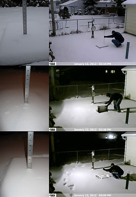
A Winter Storm Watch was in effect for the entire area Jan-12, 2012. It became a significant event because it was our first chance at more than an inch of snow since Nov-9, 2011. The snow began around 7am and lightly came down for the entire day. A moderate push of snow occurred mid-afternoon but did not last for more than a hour. Snowfall rates averaged a little over a quarter inch per hour throughout the 14-15 hour duration of snowfall. Flakes were small, light and wind blown. Here at OSNW3 we measured a storm total of 4.0 inches. (Jan 12, 2012 - 4.0") (Regional Radarloop - Jan 12, 2012) Totals from around Oshkosh range from 4.0 to 4.2 inches. A very consistent snowfall as snowfall often varies a bit from north to south in Oshkosh. The consistency continues throughout Winnebago county and the rest of the area. See image below for state wide totals (click image for more details). Don't be deceived by the purple up by Ironwood, it should really be red to orang...