Posts

Showing posts with the label Winter Predictions

Oshkosh, WI - Winter Forecast 2012-13

Image
The winter of 2012-13 begins my third year following the Earth's cycling weather patterns. One way to remain locked into them is utilizing Lezak's Recurring Cycle theory. I first learned about the LRC theory in October of 2010. An eagerness to learn the theory has grown into a passion. From a once inconceivable backyard snowfall forecast in 2010, to a complete seasonal outlook for Oshkosh in 2011, to a website dedicating my attempts at providing accurate forecast numbers for the entire Midwest in 2012-13. The concept has certainly grown on me. (Click on the screen shot to navigate to the trends. I welcome all feedback on the site, the data, the 'model' output... anything, as it will help me improve/disregard the product in the future) Oshkosh 2012-13 Winter Forecast (Dec/Jan/Feb) The forecast is based strictly on LRC theory accompanied by the formulas I've engineered to project daily surface conditions. The main focus is the middle of the atmosphere and the ...

Snowiest Stretch Of The Winter. Wait, Is It Winter Yet?

Image
Winter is showing signs of actually presenting itself in 2011-2012. According to the OSNW3 Winter Season Duration formula, if the maximum temperature for Jan-22 stays below 32 degrees OSNW3 will have finally made the transition into winter. Regardless of the outcome this is the latest beginning to winter since the 2006-07 season . A short lived Arctic air outbreak occurred Jan 19-21 giving the region a taste of winter. Here at OSNW3 our lowest recorded temperature for the three day span, -5.6 degrees, took place during the early morning hours of Jan-20. Looking ahead, using the OSNW3 forecast temperature trend based on the Lezak's Recurring Cycle theory , days will become seasonal with a good amount of them reaching the freezing mark or greater through the first half of February. The Climate Prediction Center (CPC) agrees as well for the next 14 days. I added snowfall forecast maps to the OSNW3 Weather Brief . Check them out. ( OSNW3 Weather Brief ) ( OSNW3 January Obse...

Blizzard Aftermath & An OSNW3 Snowfall Forecast Using the LRC

Image
Rather tranquil winter weather bestowed the area after the blizzard last weekend. Cloudless skies with bright sunshine reflected off the fresh snowpack providing a serotonin overload. A system skirted to our south bringing some clouds late in the week giving a break to the eyes and senses. Currently we are below the December means for temperature and precipitation, but are above in snowfall. As for what is in our near future, the CPC forecasts a 'near median' period regarding temperature and 'slightly above median' period regarding precipitation. ( OSNW3 Weather Brief ) ( OSNW3 December Observations ) (OSNW3 December 2010 Summary) (click on graph for the month summary data - it will open a new tab/window) ---- Blizzard Aftermath: Ice Shoves & Freezing Fog Early this week Steven posted a satellite image from the MODIS Today website. It is a very intriguing view of our landscape. During my ride to work the morning of Dec 13, the day after the storm, I noticed ic...

The Summer Afterglow

Image
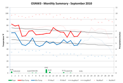
Last week my wife told me that her and her co-workers can't recall a school year starting out so chilly. I think it's just the afterglow of a warm summer. Either way, temperatures for the most part have managed to stay below average the past eleven days. Along with the relative chill are the many days with precipitation as well. Our mean temperature for the month stands at 60.5 and our days with measurable precipitation at 12. After the potentially wet and stormy weather in the coming days, long range, 6-14 day, forecasts call for above average temps and below average precip. Conditions that are typical with La Nina for our region this time of year. ( OSNW3 Weather Brief ) ( OSNW3 September Observations ) (OSNW3 September 2010 Summary) (click on graph for the month summary data - it will open a new tab/window) ---- Annual Precipitation The last week of August and the first half of September have recorded lower amounts of precipitation and are allowing for a nice drying tren...

October Top Ten Finish

Image
The last few days of October were no indication of what type of conditions prevailed for most of the month. Temperatures were down, and precipitation was up. Concluding the previous entry , October 2009 finishes in the top 10 for both the coolest and wettest of all-time. The active weather pattern of this October has got many thinking about what this Winter may have in store for snowfall. I am hoping for an above average season. See more details below... ( OSNW3 October Observations ) (OSNW3 October 2009 Summary) (click on graph for the complete month summary data - it will open a new tab/window) (OSNW3 Precipitation Through October 2009) (OSNW3 Misc Climate Happenings) Sunshine was scarce this October with only 19 Days with Sun and only one of those days were completely cloudless. We recorded 0 t-storms at OSNW3 in October which keeps our yearly total at 16. The monthly low temperature was overtaken this October at OSNW3 as the overnight low on Oct 11 dropped to 25.5° ( Monthl...