October Top Ten Finish
The last few days of October were no indication of what type of conditions prevailed for most of the month. Temperatures were down, and precipitation was up. Concluding the previous entry, October 2009 finishes in the top 10 for both the coolest and wettest of all-time. The active weather pattern of this October has got many thinking about what this Winter may have in store for snowfall. I am hoping for an above average season. See more details below... (OSNW3 October Observations)
(OSNW3 October 2009 Summary)

(click on graph for the complete month summary data - it will open a new tab/window)
(OSNW3 Precipitation Through October 2009)


(OSNW3 Misc Climate Happenings)
Sunshine was scarce this October with only 19 Days with Sun and only one of those days were completely cloudless. We recorded 0 t-storms at OSNW3 in October which keeps our yearly total at 16. The monthly low temperature was overtaken this October at OSNW3 as the overnight low on Oct 11 dropped to 25.5° (Monthly Extremes). For more daily climate information about October at OSNW3, click here.
----
The October 2009 Top 10 Performance
This October has been one to remember. It has landed itself in the top ten all-time, since 1893, for coolest mean temperature and precipitation. A feat that stands alone. Analysis of the Winters which have followed Oshkosh's 9 wettest and coolest Octobers shows that 5, respectfully, of those Winters produced less snow than the long-term average. The lowest seasonal snowfall total came in at 17.9" while the highest seasonal snowfall total topped 100" coming in at 103.6". My end conclusion is that a wet and cool October may foreshadow an average Winter snowfall.
(Wet & Cool October - Seasonal Snowfall Outlook)

***Addendum
The NWS GRB ranked a hand full of Northeast WI cities mean temp and precip for October. Turns out that the OSNW3 data crunch was almost identical to the Oshkosh Airport data. Amazingly we had the same mean temp of 44.9° and only differed by .13" of total precipitation. Click here for the NWS rankings.
----
Predictions for OSNW3's Winter
The final predictions for the upcoming OSNW3 Winter are listed below. Good luck everyone!
joshherman - September 16, 2009
Nov 18 - First 1" snowfall at OSNW3
Dec 12 - First "actual" day of Winter at OSNW3
54" - Total Snowfall at OSNW3
DoubleJ - October 1, 2009
Nov 6th - First 1" snowfall at OSNW3
Dec 3rd - First "actual" day of Winter at OSNW3
67" - Total Snowfall at OSNW3
atrain - October 11, 2009
Nov 11 - First 1" snowfall at OSNW3
Dec 5 - First "actual" day of Winter at OSNW3
57" - Total Snowfall at OSNW3
WxWatcher - Oct 12, 2009
Nov 14 - First 1" snowfall at OSNW3
Dec 2 - First "actual" day of Winter at OSNW3
48" - Total Snowfall at OSNW3
Bex - October 20, 2009
Nov 12 - First 1" snowfall at OSNW3
Dec 12 - First "actual" day of Winter at OSNW3
40" - Total Snowfall at OSNW3
Dewdrop - October 20, 2009
Nov 15 - First 1" snowfall at OSNW3
Dec 8 - First "actual" day of Winter at OSNW3
84" - Total Snowfall at OSNW3
Chris - Oct 31, 2009
Nov 18 - First 1" snowfall at OSNW3
Nov 26 - First "actual" day of Winter at OSNW3
46" - Total Snowfall at OSNW3
----
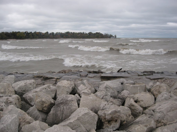
Lake Michigan Waves
Last Thursday very strong N/NE winds brought the largest waves I've documented on Lake Michigan and the Sheboygan shore. The Deland park breakwall provided the location for mighty wave crashes. At times, the spray from the crashes would seem higher than the lighthouse and the lighthouse would disappear from sight. The wind was whipping (sustained winds of 20mph, gusts of 31 mph - link) at the time I was present, which was between 445 and 545 in the afternoon. Please click on the photo for the entire set of photos and videos.
(Sheboygan, WI - Oct 22, 2009)
----
Front Of House
Things are rapidly becoming bare. This past storm system brought very windy conditions during it's exit and blew most of the remaining leaves off their branches. The fire bush is bare, which is almost a week ahead of last year.
(FOH - Oct 31, 2009)

(FOH - Nov 3, 2008)

(TAS - Oct 31, 2009)

(OSNW3 October 2009 Summary)
(click on graph for the complete month summary data - it will open a new tab/window)
(OSNW3 Precipitation Through October 2009)


(OSNW3 Misc Climate Happenings)
Sunshine was scarce this October with only 19 Days with Sun and only one of those days were completely cloudless. We recorded 0 t-storms at OSNW3 in October which keeps our yearly total at 16. The monthly low temperature was overtaken this October at OSNW3 as the overnight low on Oct 11 dropped to 25.5° (Monthly Extremes). For more daily climate information about October at OSNW3, click here.
----
The October 2009 Top 10 Performance
This October has been one to remember. It has landed itself in the top ten all-time, since 1893, for coolest mean temperature and precipitation. A feat that stands alone. Analysis of the Winters which have followed Oshkosh's 9 wettest and coolest Octobers shows that 5, respectfully, of those Winters produced less snow than the long-term average. The lowest seasonal snowfall total came in at 17.9" while the highest seasonal snowfall total topped 100" coming in at 103.6". My end conclusion is that a wet and cool October may foreshadow an average Winter snowfall.
(Wet & Cool October - Seasonal Snowfall Outlook)
***Addendum
The NWS GRB ranked a hand full of Northeast WI cities mean temp and precip for October. Turns out that the OSNW3 data crunch was almost identical to the Oshkosh Airport data. Amazingly we had the same mean temp of 44.9° and only differed by .13" of total precipitation. Click here for the NWS rankings.
----
Predictions for OSNW3's Winter
The final predictions for the upcoming OSNW3 Winter are listed below. Good luck everyone!
joshherman - September 16, 2009
Nov 18 - First 1" snowfall at OSNW3
Dec 12 - First "actual" day of Winter at OSNW3
54" - Total Snowfall at OSNW3
DoubleJ - October 1, 2009
Nov 6th - First 1" snowfall at OSNW3
Dec 3rd - First "actual" day of Winter at OSNW3
67" - Total Snowfall at OSNW3
atrain - October 11, 2009
Nov 11 - First 1" snowfall at OSNW3
Dec 5 - First "actual" day of Winter at OSNW3
57" - Total Snowfall at OSNW3
WxWatcher - Oct 12, 2009
Nov 14 - First 1" snowfall at OSNW3
Dec 2 - First "actual" day of Winter at OSNW3
48" - Total Snowfall at OSNW3
Bex - October 20, 2009
Nov 12 - First 1" snowfall at OSNW3
Dec 12 - First "actual" day of Winter at OSNW3
40" - Total Snowfall at OSNW3
Dewdrop - October 20, 2009
Nov 15 - First 1" snowfall at OSNW3
Dec 8 - First "actual" day of Winter at OSNW3
84" - Total Snowfall at OSNW3
Chris - Oct 31, 2009
Nov 18 - First 1" snowfall at OSNW3
Nov 26 - First "actual" day of Winter at OSNW3
46" - Total Snowfall at OSNW3
----
Lake Michigan Waves
Last Thursday very strong N/NE winds brought the largest waves I've documented on Lake Michigan and the Sheboygan shore. The Deland park breakwall provided the location for mighty wave crashes. At times, the spray from the crashes would seem higher than the lighthouse and the lighthouse would disappear from sight. The wind was whipping (sustained winds of 20mph, gusts of 31 mph - link) at the time I was present, which was between 445 and 545 in the afternoon. Please click on the photo for the entire set of photos and videos.
(Sheboygan, WI - Oct 22, 2009)
----
Front Of House
Things are rapidly becoming bare. This past storm system brought very windy conditions during it's exit and blew most of the remaining leaves off their branches. The fire bush is bare, which is almost a week ahead of last year.
(FOH - Oct 31, 2009)

(FOH - Nov 3, 2008)

(TAS - Oct 31, 2009)

OSNW3, The weekend we flew :) the trees were beautiful but after the wind and rain last week alot of leaves have fallen but the Bradford's are just starting to turn. ALL 4 of our outdoor cats are heavier than past years so I predict at least a much colder winter. We had about 12 fogs in Aug so I am saying it will snow in some form about 12 times in TN. (old wives tale).
ReplyDeleteHere is my burning bush
http://i378.photobucket.com/albums/oo227/mrsgreatbritian/636.jpg
SuzieE, I enjoy reading your predictions and how come up with them. My Father had two outdoor cats, they are both gone now, but I am going to ask him if he ever noticed their coats and what type of Winter we had. That's fun. I will be watching your CoCoRaHS observations this Winter... hopefully the old wives tale comes true! Thanks for sharing the photo, it's definitely burning! Have most of the leaves fallen where you live?!
ReplyDeleteOSNW3, about 75% but depends on the variety of tree. Here, Oaks and Bradfords, are typically the last to turn and fall.
ReplyDeleteWe have 13 Bradfords so in our yard about 40% of the leaves have fallen.
SuzieE, Bradford trees are unfamiliar to me. Perhaps they are around my neck of the woods, but I have yet to make the connection as I've just learned about them from you. You must have a nice looking yard when the trees are flowering, eh?!
ReplyDeleteWait... where is your prediction?!?
ReplyDeleteDewdrop, my prediction is the first on the list. :)
ReplyDelete