The Summer Afterglow
Last week my wife told me that her and her co-workers can't recall a school year starting out so chilly. I think it's just the afterglow of a warm summer. Either way, temperatures for the most part have managed to stay below average the past eleven days. Along with the relative chill are the many days with precipitation as well. Our mean temperature for the month stands at 60.5 and our days with measurable precipitation at 12. After the potentially wet and stormy weather in the coming days, long range, 6-14 day, forecasts call for above average temps and below average precip. Conditions that are typical with La Nina for our region this time of year.
(OSNW3 Weather Brief)
(OSNW3 September Observations)
(OSNW3 September 2010 Summary)
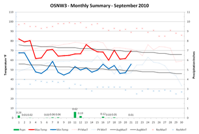
(click on graph for the month summary data - it will open a new tab/window)
----
Annual Precipitation
The last week of August and the first half of September have recorded lower amounts of precipitation and are allowing for a nice drying trend for the saturated grounds of June and July. The graph below shows that September has been a dry month since 2007 here at OSNW3. With less than 10 days remaining I am hopeful that we can get to average in 2010.
(OSNW3 Annual Precipitation Summary - Sep 22, 2010)


----
Firsts & Lasts
As we head into autumn the chance for frost and freeze warnings become more frequent. Of course, this then brings the potential for snow and the next thing we know, it's winter. The link below is a listing of OSNW3's firsts & lasts history, which begs to mention the upcoming predictions for the First 1" snowfall at OSNW3, the First "actual" day of Winter at OSNW3, and the Total Snowfall for the season at OSNW3. If interested in participating see this archived blog entry for info.
OSNW3 Winter Firsts & Lasts
(Average Freeze Dates Across North-Central and Northeast WI)

For the most recent Fall Freeze information click here.
----
CoCoRaHS Station WI-BN-6
Back in April we celebrated my Mom's entry into the precipitation observation world with CoCoRaHS. Since then she has gained acceptance into the NWS UCOOP program, and been gifted a live webcam and an occasionally updated website. The WIBN6 website can be found here and the webcam viewed in a larger frame by clicking the image below.
(WI-BN-6 Live Webcam)

----
Front Of House
We remain on cut number 10. The birch tree in the front yard is changing to yellow and the tree across the street is changing to red. The Fall Color Report from TravelWisconsin lists the Oshkosh area as 0-25% with a peek in 4 weeks. On the website, I've added CoCoRaHS daily observation maps on the main page.
(FOH - Sep 20, 2010)

(TAS - Sep 20, 2010)

(OSNW3 Weather Brief)
(OSNW3 September Observations)
(OSNW3 September 2010 Summary)
(click on graph for the month summary data - it will open a new tab/window)
----
Annual Precipitation
The last week of August and the first half of September have recorded lower amounts of precipitation and are allowing for a nice drying trend for the saturated grounds of June and July. The graph below shows that September has been a dry month since 2007 here at OSNW3. With less than 10 days remaining I am hopeful that we can get to average in 2010.
(OSNW3 Annual Precipitation Summary - Sep 22, 2010)


----
Firsts & Lasts
As we head into autumn the chance for frost and freeze warnings become more frequent. Of course, this then brings the potential for snow and the next thing we know, it's winter. The link below is a listing of OSNW3's firsts & lasts history, which begs to mention the upcoming predictions for the First 1" snowfall at OSNW3, the First "actual" day of Winter at OSNW3, and the Total Snowfall for the season at OSNW3. If interested in participating see this archived blog entry for info.
OSNW3 Winter Firsts & Lasts
(Average Freeze Dates Across North-Central and Northeast WI)
For the most recent Fall Freeze information click here.
----
CoCoRaHS Station WI-BN-6
Back in April we celebrated my Mom's entry into the precipitation observation world with CoCoRaHS. Since then she has gained acceptance into the NWS UCOOP program, and been gifted a live webcam and an occasionally updated website. The WIBN6 website can be found here and the webcam viewed in a larger frame by clicking the image below.
(WI-BN-6 Live Webcam)
----
Front Of House
We remain on cut number 10. The birch tree in the front yard is changing to yellow and the tree across the street is changing to red. The Fall Color Report from TravelWisconsin lists the Oshkosh area as 0-25% with a peek in 4 weeks. On the website, I've added CoCoRaHS daily observation maps on the main page.
(FOH - Sep 20, 2010)

(TAS - Sep 20, 2010)

What exciting news from your mom! I wish I had a web cam set up for our station. It'll be fun to compare both of your areas this winter.
ReplyDeleteHow many years have you taken a picture of the tree across your street? It'd be something to compare peak color/date from year to year.
Great post as usual! I'm ready for cool weather to come down here. I look forward to stepping out for work in the morning and breathing in the lung-reviving crispness that is our fall air.
WxWatcher, thanks for reading and commenting. I appreciate it. It is exciting. Now the next 10 years will be spent gathering data investigating whether or not she really lives in the "snow belt of Suamico". haha.
ReplyDeleteI started taking photos of the tree across the street in 2008. I have a comparison in an entry of Oct 2009 that compares the 2008 version and the 2009 version on Oct 7. I plan on taking a photo on Oct 7 this year as well.
Today is cool and windy. I ventured over to the east side of the lake and captured some photos and vids of the waves. I have a link on the right side of my blog in the Twitter area. Check them out if you got time.
Looking forward to reading about the weather in your area soon. Hope school is going well.