Blizzard Aftermath & An OSNW3 Snowfall Forecast Using the LRC
Rather tranquil winter weather bestowed the area after the blizzard last weekend. Cloudless skies with bright sunshine reflected off the fresh snowpack providing a serotonin overload. A system skirted to our south bringing some clouds late in the week giving a break to the eyes and senses. Currently we are below the December means for temperature and precipitation, but are above in snowfall. As for what is in our near future, the CPC forecasts a 'near median' period regarding temperature and 'slightly above median' period regarding precipitation.
(OSNW3 Weather Brief)
(OSNW3 December Observations)
(OSNW3 December 2010 Summary)

(click on graph for the month summary data - it will open a new tab/window)
----
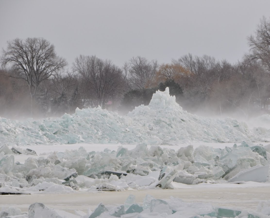
Blizzard Aftermath: Ice Shoves & Freezing Fog
Early this week Steven posted a satellite image from the MODIS Today website. It is a very intriguing view of our landscape. During my ride to work the morning of Dec 13, the day after the storm, I noticed ice shoves out on the lake ice south of Neenah and to the north a very large area of steam rising from the lake. I figured the high winds from the storm must have broke the ice and moved it in a similar fashion as the strong winds break the ice in spring. Later in the week I was informed that ice shoves moved into view offshore the Lasky residence in Oshkosh. The ground level ice shove images below are courtesy of Courtney Lasky. Along with the photos are her comments. Many of the ice shoves on the lake are faintly visible in the 250m satellite version of the image linked from Steven above. Amazing! Thanks for the photos Court and for the satellite image Steven!


We woke up on Sunday [Dec 12] to these gigantor shoves- totally sucks, as the lake had been like BUTTER! I had just been commenting last week that it was the smoothest that I'd ever seen Winnebago freeze, and was looking forward to snow, so I could get out there and ski. NOW, that is a little compromised... Figure there were a lot of snowmobile owners crying on Sunday morning... GREAT storm though- wasn't it?! WOOHOO!!
Blizzard aftermath events other than the ice shoves above consisted of consecutive mornings where freezing fog was taking place near Lake Winnebago and atop the Niagara Escarpment. I snapped a few photos of the fog during my travels to Sheboygan this week. More freezing fog photos can be found here.
(Freezing Fog - Dec 14, 2010)

----
Snowfall Predictions Using the LRC
I have decided to try my hand at creating a personal snowfall forecast this winter using the little knowledge I have of the LRC. After I began I asked myself why I was going through the trouble of researching and analyzing all this. I have several questions that need attention. For example, when will the next snow day occur at my wife's school? Or when can we take a short trip without having to find a substitute observer? Or will it snow next week when I drive to a customer site 60 miles away? Or when is the best time to play on the shores of Lake Superior and Lake Michigan? Questions like these need answers and it is all possible to obtain using the LRC. So I continued. I researched the length of the LRC (47ish days), precipitation totals, archived radar loops, and 500mb height contour maps. I created a spreadsheet of what I found listing the cycles and daily precipitation totals during each and highlighting when the chances of snowfall may take place in the area from now through January. The spreadsheet can be found here. To sum up the spreadsheet, it shows Dec 19-23 may have a low move in from the W bringing an inch. Dec 28-31 there could be a low that moves in from the SW where greater than two inches could fall. Jan 6-12 a series of disturbances could work through leaving three or more inches. Jan 15-18 another low moves in from the SW potentially leaving two or more inches snow. And then the big one, Jan 25-29, the return of the 'Great Lakes Cyclone' once again, the third iteration. It turns out these last dates coincide with the school and work week taking place on a Wednesday through Friday. A snow day to look forward to perhaps. Overall snow totals from now through January could be somewhere around 14 inches in my backyard. That amount would put OSNW3 over the two months of December and January average total snowfall for Oshkosh.
My confidence in the LRC is relatively high at this point in my recent following of the cycle. Jeremy Nelson and Mark Baden of WISN WeatherWatch 12 have kept the LRC talk in top priority. Jeremy's long range forecast can be found by following this link to the blog entry. "The great thing about the LRC is that anyone can follow along and try to make their own forecasts". We'll see if I should hang up the LRC crystal ball as the next cycle comes to a close. :)
(2010-11 OSNW3 LRC List)

(red fill is start/stop points in forecast, chances of snowfall are lt grn , grn , and drk grn)
----
Front Of House
It's looking a lot like winter around here. As a matter of fact, Dec 18 is the official first day of winter at OSNW3 this season. With that milestone, I would like to note that no one has predicted correctly in this years winter predictions. First 1" came on Dec 9 and the First day of winter Dec 18 as stated above. The predictions can be found here.
(FOH - Dec 18, 2010)

(OSNW3 Weather Brief)
(OSNW3 December Observations)
(OSNW3 December 2010 Summary)
(click on graph for the month summary data - it will open a new tab/window)
----
Blizzard Aftermath: Ice Shoves & Freezing Fog
Early this week Steven posted a satellite image from the MODIS Today website. It is a very intriguing view of our landscape. During my ride to work the morning of Dec 13, the day after the storm, I noticed ice shoves out on the lake ice south of Neenah and to the north a very large area of steam rising from the lake. I figured the high winds from the storm must have broke the ice and moved it in a similar fashion as the strong winds break the ice in spring. Later in the week I was informed that ice shoves moved into view offshore the Lasky residence in Oshkosh. The ground level ice shove images below are courtesy of Courtney Lasky. Along with the photos are her comments. Many of the ice shoves on the lake are faintly visible in the 250m satellite version of the image linked from Steven above. Amazing! Thanks for the photos Court and for the satellite image Steven!

We woke up on Sunday [Dec 12] to these gigantor shoves- totally sucks, as the lake had been like BUTTER! I had just been commenting last week that it was the smoothest that I'd ever seen Winnebago freeze, and was looking forward to snow, so I could get out there and ski. NOW, that is a little compromised... Figure there were a lot of snowmobile owners crying on Sunday morning... GREAT storm though- wasn't it?! WOOHOO!!
Blizzard aftermath events other than the ice shoves above consisted of consecutive mornings where freezing fog was taking place near Lake Winnebago and atop the Niagara Escarpment. I snapped a few photos of the fog during my travels to Sheboygan this week. More freezing fog photos can be found here.
(Freezing Fog - Dec 14, 2010)

----
Snowfall Predictions Using the LRC
I have decided to try my hand at creating a personal snowfall forecast this winter using the little knowledge I have of the LRC. After I began I asked myself why I was going through the trouble of researching and analyzing all this. I have several questions that need attention. For example, when will the next snow day occur at my wife's school? Or when can we take a short trip without having to find a substitute observer? Or will it snow next week when I drive to a customer site 60 miles away? Or when is the best time to play on the shores of Lake Superior and Lake Michigan? Questions like these need answers and it is all possible to obtain using the LRC. So I continued. I researched the length of the LRC (47ish days), precipitation totals, archived radar loops, and 500mb height contour maps. I created a spreadsheet of what I found listing the cycles and daily precipitation totals during each and highlighting when the chances of snowfall may take place in the area from now through January. The spreadsheet can be found here. To sum up the spreadsheet, it shows Dec 19-23 may have a low move in from the W bringing an inch. Dec 28-31 there could be a low that moves in from the SW where greater than two inches could fall. Jan 6-12 a series of disturbances could work through leaving three or more inches. Jan 15-18 another low moves in from the SW potentially leaving two or more inches snow. And then the big one, Jan 25-29, the return of the 'Great Lakes Cyclone' once again, the third iteration. It turns out these last dates coincide with the school and work week taking place on a Wednesday through Friday. A snow day to look forward to perhaps. Overall snow totals from now through January could be somewhere around 14 inches in my backyard. That amount would put OSNW3 over the two months of December and January average total snowfall for Oshkosh.
My confidence in the LRC is relatively high at this point in my recent following of the cycle. Jeremy Nelson and Mark Baden of WISN WeatherWatch 12 have kept the LRC talk in top priority. Jeremy's long range forecast can be found by following this link to the blog entry. "The great thing about the LRC is that anyone can follow along and try to make their own forecasts". We'll see if I should hang up the LRC crystal ball as the next cycle comes to a close. :)
(2010-11 OSNW3 LRC List)
(red fill is start/stop points in forecast, chances of snowfall are lt grn , grn , and drk grn)
----
Front Of House
It's looking a lot like winter around here. As a matter of fact, Dec 18 is the official first day of winter at OSNW3 this season. With that milestone, I would like to note that no one has predicted correctly in this years winter predictions. First 1" came on Dec 9 and the First day of winter Dec 18 as stated above. The predictions can be found here.
(FOH - Dec 18, 2010)
Thanks for the mention and link Josh!
ReplyDeleteWow! Those ice shoves are awesome. That's pretty unusual for Dec. isn't it?
Thanks also for the LRC spread sheet! Great job on that. You've made my life a lot easier. I'm tired of counting backwards 46-48 days every time I want to look up a date.
Very cool to see that your dates and the ones I came up with coincide. The LRC rocks!
Whoa! You go dude! Way to jump head first with the LRC forecasting. I've been amazed so far to watch these forecasts pan out, and so far, they've been spot on. I've been reading Lezak's blog daily, and jumping to the WISN blog when I can. I love the technical talk Jeremy includes in his entries.
ReplyDeleteTurn that snow machine on. I'm ready for more!
I would have tried making a forecast based on the LRC, but I had only heard about it a couple weeks ago.
ReplyDeleteAnyway, awesome work with the forecast! Can't wait to see the "Great Lakes Cyclone" make another visit-- hopefully bringing more snow down here.
Josh, it's time for you to consider a new career path - meteorology! My goodness man, you are going full bore. Certainly the NWS or a local news outlet would love having you on staff!?
ReplyDeleteAs a side note, my monthly general weather column has been accepted with open arms by our local weekly newspaper. I’ve sent the January installment in all ready and will start working on February between Christmas and the New Year.
I agree with Bob, Josh. You have a great passion for this.
ReplyDeleteBob, how can we "follow" your column? I'd be a faithful reader.
Steven, no sweat man. I would imagine the dates and times of the storms passing through EC and SE WI would be identical for the most part. The precip that falls, not so much. The LRC does indeed rock!
ReplyDeleteWxWatcher & Bob, thanks for the kind words guys! I am glad you two read and comment, keeps the spirit alive. Looking forward to reading your column Bob, and I do have a blog (copy and paste this one is all I do) on the Oshkosh Northwestern's homepage titled 'weather spotter' but it would seem the great people of Oshkosh do not share the same passion for weather and climate as us. :)
Chris, thanks! I say you go for it. Make a snowfall forecast for northern Waukesha! DO IT.
Oh, and Steven, yes the ice shoves are unusual in December as far as I know. I've lived here since 1996.
ReplyDeleteFor anyone that is interested I updated the snowfall forecast spreadsheet. Details on the actual html page. Click the image in the body of the blog entry.
ReplyDelete