Snow!
Nope, not here in Oshkosh, But in the Dallas, TX area. Seems the Dallas area received a measurable snowfall before Northeast WI this year. A good friend of ours who lives in Dallas reported early this morning that it was snowing. Below is his photo. His photo doesn't show any accumulation and it is hard to pick out the flakes, but in the distance it sure looks like it is snowing. I believe him. Also, below is a snapshot of a webcam in the Fort Worth area with some definite accumulation on the grass.
(Dallas, TX area - Dec 2, 2009)
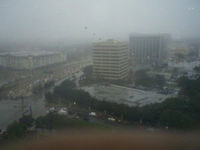
(photo courtesy of Brett Eifler)
(Fort Worth, TX area - Dec 2, 2009)

(photo courtesy of WXnation.com)
(Regional radarloop)

(click on radar for a larger image)
----
Fun Satellite Images
Last night I was surfing the WisconsinView site satellite images. I came across three that stood out to me. Below are descriptions of each.
-First is the day prior to the ice shoves on Lake Winnebago. The ice on the lake is noticeably cracked and separated. Not more than a day after this image, that ice was pushed onshore. To revisit the happenings that day, please see this blog entry.
(Mar 30, 2009 - Lake Winnebago)

(click on image for the entire image)
-Second is of what may or may not be happening on Lake Superior during the day of July 23, 2009. Looks like a major marine layer of fog encapsulating the entire lake! Perhaps Tim or Nathan could shed some light on this?!
(Jul 23, 2009 - Lake Superior)

(click on image for a larger view)
-Third is of a small low pressure that moved through Northeast WI and the Eastern Upper Peninsula this Summer. From both satellite and radar it looked like a small hurricane. Pretty neat in my opinion.
(Aug 14, 2009 - Low Pressure)

(click on image for a larger view)
(Aug 14, 2009 - Radar Loop)

(click on radar for a larger image)
---
You guessed it. I'm patiently waiting for snow! :)
***Addendum - It snowed on Dec 3 here in Oshkosh. Patience is a virtue.
(Dallas, TX area - Dec 2, 2009)

(photo courtesy of Brett Eifler)
(Fort Worth, TX area - Dec 2, 2009)

(photo courtesy of WXnation.com)
(Regional radarloop)
(click on radar for a larger image)
----
Fun Satellite Images
Last night I was surfing the WisconsinView site satellite images. I came across three that stood out to me. Below are descriptions of each.
-First is the day prior to the ice shoves on Lake Winnebago. The ice on the lake is noticeably cracked and separated. Not more than a day after this image, that ice was pushed onshore. To revisit the happenings that day, please see this blog entry.
(Mar 30, 2009 - Lake Winnebago)

(click on image for the entire image)
-Second is of what may or may not be happening on Lake Superior during the day of July 23, 2009. Looks like a major marine layer of fog encapsulating the entire lake! Perhaps Tim or Nathan could shed some light on this?!
(Jul 23, 2009 - Lake Superior)

(click on image for a larger view)
-Third is of a small low pressure that moved through Northeast WI and the Eastern Upper Peninsula this Summer. From both satellite and radar it looked like a small hurricane. Pretty neat in my opinion.
(Aug 14, 2009 - Low Pressure)

(click on image for a larger view)
(Aug 14, 2009 - Radar Loop)
(click on radar for a larger image)
---
You guessed it. I'm patiently waiting for snow! :)
***Addendum - It snowed on Dec 3 here in Oshkosh. Patience is a virtue.
I am not at my station. This morning, I had recorded just over 2 inches. Tallahassee had just under 3 inches this morning in about 3 hours. When I get home, I will check things out. We still have some scattered precip.
ReplyDeleteI don't know what my station number is... is that like forgetting my call sign??? Something like GA00001 or something.
Don't forget about El Paso Texas Josh, they had snow as well the other day, a couple inches accumulated. All sorts of pics were shown on TWC, and TWC also reported that Dallas/Fort Worth was getting snow This Morning. Can you believe it? More snow in the deep south than around the Great Lakes! The radar image from August looks impressive, those Summertime Meso-Lows always look very cool on satellite/radar imagery. As far as the July 23rd event, I'm sure it was either fog/stratus over Lake Superior or just cool air rushing over the "balmy" Lake Superior water temps creating alot of cold air Stratocumulus clouds, I'll check out the data from that day to see what it was like here in Duluth.
ReplyDeleteOh and btw...Looks like the lake effect snow machine is beginning in the snowbelts off to my east...Should be a fairly decent event.
ReplyDeleteDewdrop, the system looked mighty impressive on the radar. I believe it is like forgetting your call sign. Shame. :)
ReplyDeleteTim, I heard about the El Paso snow. Didn't see any photos though. I suppose I should google it. I can believe the Dallas snowfallt. It snows there once and a while. My buddy said it was miserable down there today. He's born and raised in Green Bay, moved to TX about 3 years ago and is already over acclimated. I will give him a break though as he never was a big fan of Winter. On all the satellite images I looked at none were like the July 23rd one. The entire lake is covered in clouds. Any thing you find I'd like to read, so feel free to share. I adore the LES machine. As far as I am concerned and as far as snowfall is concerned, there is nothing better than a solid lake effect snowfall.
Aww Dang O, thats kinda a drag Texas gets snow before you! I'm kinda hoping for some sticking snow here myself, becuase we haven't had it yet. We did have some light flurries last night, so we have a Trace of snow on the ground right now.
ReplyDeleteD, I am at work in Neenah and the snow is accumulating on cars. It also looks like it may be accumulating on my neighbors baron garden soil as well via my webcam. All the accumulations are most likely just Trace amounts.
ReplyDeleteI see some snow falling in your area today. Any chance for an inch? Boy all of our predictions have been blown out of the water this year.
ReplyDeleteAmazing photos. I always like to watch the effect of land or bodies of water on storms. My favorite part of your convective event radar loop is when the storm picks up steam after it passes over Lake Michigan. It really explodes! Very cool. Thanks again for posting.
We had our first flakes of the year yesterday. It was nice to see it falling, but only for a few minutes.
WxWatcher, from the webcam view, it looks like some snow has accumulated in the rain gauge. The temp is holding in the upper 20's so there is a chance that when I get home I might be able to actually measure some snow on the snow board. We'll see!
ReplyDeleteI am glad you enjoyed the satellite images and radar loop. I know I did. It's endless fun. :)
It's 3:07, and I can see a definite accumulation on your snow board. I look forward to your report in the morning!
ReplyDeleteI checked out the johndee.com website. Very cool resource.
WxWatcher, OSNW3 has seen the first accumulating snowfall of the season! I don't want to spoil the fun so I won't tell you what I measured. It's still under an inch... but if we get another burst like we did just before 3pm, we have a chance of surpassing an inch. :)
ReplyDeleteAnd, yes, John Dee's site is a solid resource!
I did some research This Afternoon from July 23rd, 2009. The 500 mb charts showed that the region was locked under a northwest flow aloft with a cut-off low up in the Manitoba Province area in Canada. According to my weatherblog from that day, there was widespread fog some of which was dense covering Lake Superior and at times the Duluth Harbor area. The temps were in the 50s and 60s near Lake Superior with 70s and 80s away from the Lake. That's all I could find out from that day. Just flurries up here in Duluth MN Today, nothing measurable, but it sure is chilly, barely 20 degrees all day long.
ReplyDeleteTim, awesome job on researching July 23rd. Did you reference the NCEP/HPC daily wx maps? I am happy that you referenced your own blog entry as well as the 500mb. There are many reasons why we put our data on the Internet, and this is one of them. Thanks for taking the time to look further into it. We were in the upper 70's around here that day with mostly sunny conditions.
ReplyDeleteIt's nice to have snow on the grass. Today was my daughters first time to feel falling snow hit her face. :)
That's awesome about your daughter getting her first taste of snow! Nothing like a kid running around having a great time in snow! I print out the 500 mb analysis on a daily basis off the SPC site, so I went back thru my papers to find out what the winds aloft were doing, then I looked back at my blog for that particular day. Hey, you better keep a close eye on next Tuesday/Wednesday, the models are really cranking up one heck of a winter storm. Seems like it will miss me, but it could hit your area pretty good, unless the storm track changes.
ReplyDeleteIt's Winter now, so you have to mention "unless the storm track changes." each time, eh?!. :)
ReplyDeleteThanks for clarifying. I was curious on how you conducted your research. It's a learning experience each time I find out how others do their thing...
My daughter stared out the window this morning watching the big flakes fall. Just light flurries, but it caught her attention. She's a year old now, so this season will actually register with her. :)
Dallas beat us to the snow! Darn. ;)
ReplyDeleteWe have our first Sticking snowfall of the season here at Clayton,WI Flurries continued all night last night into today! We got an inch on the ground! Congrats on your accumulations... Finally LOL
ReplyDeleteI forgot to mention that actually now (8:37PM) It's still snowing and it has actually picked up even more then the flurries we had all day durning the daylight hours.
ReplyDeleteSNOW! Yes! Last night. One down, hopefully 11 more to go.
ReplyDeleteIt is interesting that the Nashville NWS office posted on their website 2003 as the last large snowfall for Nashville but earlier in Feb this station had 9 inches. Just like in Feb we got it and Nashville got none today and very little in Feb.
D, very nice! It flurried here this morning but then the clouds broke and we actually saw the sun.
ReplyDeleteSuzieE, I see that almost a third of all CoCoRaHS observations from TN reported accumulating snowfall! How exciting. What is your CoCoRaHS handle? I can't recall...
Lucky 13. TN-ML-13
ReplyDelete