Posts

Post Winter Storm Report - Apr 19

Image
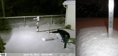
The snow started about 11am on Apr 19 and intensified as the day progressed. The afternoon brought many bolts of lightning and claps of thunder. By the time I was able to leave Holland, WI my car was covered in about six inches of fresh heavy wet snow. The drive back to Oshkosh was long and tedious as roads were snow covered. Winds were whipping as well enhancing the low visibilities. I was able to snap a few photos in Holland and get a measurement once I got home. At the time of observation the wind was gusting considerably and the snow was winding down. A radar loop and a webcam time lapse can be found by clicking the links. A few photos of the storm are located here . Precip: 1.23" Snow: 6.4" Snowdepth: 6" (Apr 19, 2011 - 6.4" - 9:53pm) (Apr 19, 2011 - Rain Gauge) (Apr 19, 2001 - Weight Of Snow) (Apr 19, 2011 - Holland, WI - 1pm) (Apr 19, 2011 - Holland, WI - 7pm) ---- April Snow Stats I quickly gathered the all-time greatest snowfalls in Oshkosh for the ...

A Typical First Half Of April

Image
I believe the weather we've been experiencing this first half of April is quite typical of what one should expect. A volatile atmosphere swinging up and down as the transition to spring takes place. I will admit I am itching to get out on the golf course. Last year at this time I was closing in on my first 18 being logged into the record book. Thinking back to April 2010, it's shocking to realize that this April to date has been 12.1 degrees cooler regarding daily max temps. However, with only two days above 60 degrees thus far we are still above the Oshkosh average by 2.2 degrees. As for precipitation we are just 4 tenths of an inch below the Oshkosh average. A fairly typical first half of April in my opinion. Still though, I am in search of a warm spell no matter how typical it has been. It would seem one is about two weeks away according to the OSNW3 backyard max temp forecast using the LRC. There is much work to refine the technique, I will admit, but none the less, ...

The Timely Taste Of Spring

Image
It's a shame winter at OSNW3 had to go and end just as another two weeks of winter like weather would blanket the property. After the Great Lakes Cyclone IV passed, like in each previous cycle, a surge of cold air spread over the region locking us into an extended period of winter. Our daily maximum temperature for Mar 24 thru Apr 5 was 36 degrees, 10 degrees below the average. Six of those nights recorded minimum temperatures in the teens. Almost completely opposite from last year during the same time period. A well deserved warm-up is near though. The forecasting computer model massive has finally picked up on it and have it on their radar, something the LRC community has been talking about for months. It's the second week of April and it will end as our first real taste of spring. If it's not raining I will be raking. The monthly climate summary for March can be found here . ( OSNW3 Weather Brief ) ( OSNW3 April Observations ) (OSNW3 April 2011 Summary) (clic...

Oshkosh Winters Of 1977-78 & 1978-79 Remembered & Finding Lezak's Recurring Cycle Within Them

Image
With the fourth passing of the 'signature' storm in this seasons LRC and winter keeping a grip on the region I feel it is a great time to share the research I've done on the Oshkosh winters of 1977-78 and 1978-79. I decided to research these winters for a couple of reasons. The first being to learn the weather, climate and local history that accompanied the second all-time back-to-back snowiest seasons in Oshkosh's recorded history. The second reason being to find Lezak's Recurring Cycle within them and hopefully extend my learning on the theory by providing visual details on the patterns within the cycles. ---- RESEARCH Participation in discussions on the WeatherWatch12 blog since Oct of 2010 has led me to many great resources for learning about our atmosphere and the LRC. After attempting to find the LRC within previous years on my own with little success, a few lessons from Scott at LRCweather of ways to find the cycle quickly helped ignite the resea...

The Great Lakes Cyclone IV

Image
Our neighbors across the street, the owners of the TAS , were raking their front lawn this past Sunday. I stepped out of my front door and mentioned to them that it is to early for raking as I still had snow in my front yard. I also mentioned that a storm was coming and there will soon be snow covering the ground again. Either way, they are ahead of the spring clean up game and it inspired me later that afternoon to finish trimming a tree and picking up random small pieces of trash that some how float into my yard. It was a well deserved clean up after 95 days of winter. Winter officially ended at OSNW3 on Mar 22. It doesn't look like it at the moment with the fresh coating of snow or feel like it with temps dipping into the low teens at night barely making it above freezing for highs the next day. Adding the fact that we are locked into this pattern for another week or more will make it feel like winter even more. However, a warm up is coming. Plan for the second week of ...

Winter/Spring Metamorphosis

Image
The seasonal transition from winter to spring is upon us. With a minimal base of snow lingering, chances of rain this week, and max temps not forecast to dip below the freezing mark for the next two weeks, visions of Old Man Winter packing up and leaving will become a common site. Officially winter has a very good chance of ending mid next week here at OSNW3 which is quite typical since 2006. However, looming is the 'signature' storm of this years LRC ( Lezak's Recurring Cycle ). Most everyone remembers the storms from Oct 25-28 , Dec 11-12 , and Feb 1-2 and now we look forward to the return mid to late next week. Models will zig zag the track and timing up until the last minute so pin pointing precip type is difficult. Just know that it's coming and it will affect our region in a similar fashion as the three previous times through the cycle. ( OSNW3 Weather Brief ) ( OSNW3 March Observations ) (OSNW3 March 2011 Summary) (click on graph for the month summary dat...

Meteorological Spring Has Arrived!

Image
Meteorological winter has come to an end. It has been a season of extraordinary learning accompanied by many, many snow measurements. Since the last blog entry it has snowed seven times and I've taken at least twice as many measurements. Twenty-one inches of snow fell this February at OSNW3 which is more than double the average snowfall for Oshkosh. We maintained almost a ten inch snow depth for the month but not with out a complete melt down over a seven day stretch with temperatures topping the freezing mark to start the second half. The final week knocked the spring fever out of the air reminding all of us winter really wasn't over. March looks to be an active month trending toward the wintry side peaking near the end of the month with the fourth iteration of the Great Lakes Cyclone . Spring will be delayed a few weeks compared to last year with our first real taste not until the second week of April. March Forecast – Based on Lezak’s Recurring Cycle - Jeremy Nelson Wea...