The Timely Taste Of Spring
It's a shame winter at OSNW3 had to go and end just as another two weeks of winter like weather would blanket the property. After the Great Lakes Cyclone IV passed, like in each previous cycle, a surge of cold air spread over the region locking us into an extended period of winter. Our daily maximum temperature for Mar 24 thru Apr 5 was 36 degrees, 10 degrees below the average. Six of those nights recorded minimum temperatures in the teens. Almost completely opposite from last year during the same time period. A well deserved warm-up is near though. The forecasting computer model massive has finally picked up on it and have it on their radar, something the LRC community has been talking about for months. It's the second week of April and it will end as our first real taste of spring. If it's not raining I will be raking. The monthly climate summary for March can be found here.
(OSNW3 Weather Brief)
(OSNW3 April Observations)
(OSNW3 April 2011 Summary)
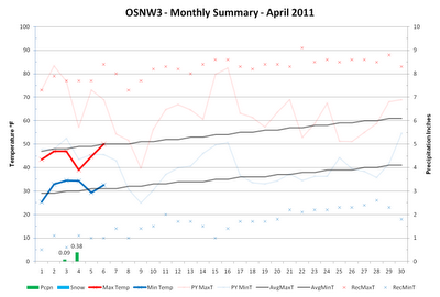
(click on graph for the month summary data - it will open a new tab/window)
----
Weekly Snowfall
Besides the snow and sleet from the Great Lakes Cyclone IV we've only had a few flakes here and there make their way to the surface. Two days, Mar 26-27, with some LES flurries off of Lake Michigan and then some sleet just before the thunderstorms and hail on Apr 3. Below are the measurements from the Great Lakes Cyclone IV.
(Mar 23, 2011 - 3.1")

(Mar 24, 2011 - 1.5")

----
Thunderstorms and Hail
The morning of Apr 3 was a historic one here at OSNW3. We witnessed our first ever hail fall from the sky. Hail fell three separate times for about a minute each. The hail measured around a 1/4" in diameter, much like the size of a pea. Quick bursts of moderate rain accompanied the storms creating some typical minor field and street flooding. A video of the hail can be found here.
(Hail - Apr 3, 2011)

(Flooding - Apr 3, 2011)

----
First Real Taste of Spring and the LRC
I have been hedging my bets for this weekends warm-up to take place for many weeks now. I am able to because of my confidence in Lezak's Recurring Cycle. Each time through the cycle at OSNW3 this pattern has produced multiple days that were 10+ degrees above the Oshkosh average maximum temperature.
Nov 8-12 (+15°)
Dec 30-31, Jan 1 (+17°)
Feb 14-18 (+12°)
10+ degrees above average on any day between Apr 7-11 would put OSNW3 into the 60's. These types of temperatures will feel mighty nice after enduring the last gasp of winter the past two weeks. For an interactive look at this particular pattern I would suggest opening each of the 500mb maps, linked below, in their own browser tab. Then move the maps forward in time from each instance to the dates mentioned above paying particular attention to the movement of the atmosphere. It is evident a warm up was coming months ago due to the cycling pattern.
- Nov 5, 2010
- Dec 26, 2010
- Feb 14, 2011
(500mb Heights - 14 days centered on dates above and Apr 5, 2011)

One can do the same thing for the cold snap that followed the Great Lakes Cyclone, more popularly known as this years LRC 'signature' storm, by opening the links below and working through them as explained above. A persistent northwest flow set up ushering in cooler than average air.
- Oct 26, 2010
- Dec 11, 2010
- Feb 1, 2011
- Mar 23, 2011
(500mb Heights - 14 days centered on dates above)

More in depth information about these particular patterns within this years LRC can be found in the WeatherWatch12 and LRCweather blogs. Following these and other cycle analysis blogs acts as a catalyst for taking the bull by the horns. Recently I have been working with OSNW3 surface data attempting to forecast temperatures using the LRC. I came up with a very crude and simplistic formula that proved to have a 50% verification within a 10-15 degree range during the previous cycles 3 and 4. A good success rate for predicting temperatures a month or more in advance in my opinion. See graphs below for an analysis of previous cycles and a backyard temperature forecast through mid May using the formula. A larger view of each graph can be found by clicking on the image. The forecast graph for cycle 5 says it should certainly be near or above 60 here at OSNW3 this weekend!


The formula I created finds the mean deviation from the 30 year average for the particular day using the temp from that day, the day before and the day after within each cycle. The graph legend consists of the following acronyms. Cycle Max (CycMax), Cycle Min (CycMin), Forecast Max Temp (ForMaxT), Forecast Max Temp Range Hi (ForMaxTRH, Forecast Max Temp Range Lo (ForMaxTRL), Actual Max Temp at OSNW3 (ActualMaxT), and the Oshkosh Average Max Temp (OshAvgMaxT).
If there are any questions about my research or how I presented the material just let me know in the comments section of the blog. Thanks!
----
Front Of House
As of Apr 6, my mother's station WIBN6 still has 11" of snow on the ground. I am sure this weekends warm-up will melt a lot of it creating minor flooding and rapids on the Suamico river. As for OSNW3, all of our snow has melted off and we're looking forward to the spring clean up. I updated the OSNW3 photo album and the OSNW3 backyard precipitation forecast. Seems we will be rolling into a cool and active weather pattern in about a week or so.
(FOH - Apr 1, 2011)

(Millers Bay - Apr 1, 2011)

(OSNW3 Weather Brief)
(OSNW3 April Observations)
(OSNW3 April 2011 Summary)
(click on graph for the month summary data - it will open a new tab/window)
----
Weekly Snowfall
Besides the snow and sleet from the Great Lakes Cyclone IV we've only had a few flakes here and there make their way to the surface. Two days, Mar 26-27, with some LES flurries off of Lake Michigan and then some sleet just before the thunderstorms and hail on Apr 3. Below are the measurements from the Great Lakes Cyclone IV.
(Mar 23, 2011 - 3.1")

(Mar 24, 2011 - 1.5")

----
Thunderstorms and Hail
The morning of Apr 3 was a historic one here at OSNW3. We witnessed our first ever hail fall from the sky. Hail fell three separate times for about a minute each. The hail measured around a 1/4" in diameter, much like the size of a pea. Quick bursts of moderate rain accompanied the storms creating some typical minor field and street flooding. A video of the hail can be found here.
(Hail - Apr 3, 2011)

(Flooding - Apr 3, 2011)

----
First Real Taste of Spring and the LRC
I have been hedging my bets for this weekends warm-up to take place for many weeks now. I am able to because of my confidence in Lezak's Recurring Cycle. Each time through the cycle at OSNW3 this pattern has produced multiple days that were 10+ degrees above the Oshkosh average maximum temperature.
Nov 8-12 (+15°)
Dec 30-31, Jan 1 (+17°)
Feb 14-18 (+12°)
10+ degrees above average on any day between Apr 7-11 would put OSNW3 into the 60's. These types of temperatures will feel mighty nice after enduring the last gasp of winter the past two weeks. For an interactive look at this particular pattern I would suggest opening each of the 500mb maps, linked below, in their own browser tab. Then move the maps forward in time from each instance to the dates mentioned above paying particular attention to the movement of the atmosphere. It is evident a warm up was coming months ago due to the cycling pattern.
- Nov 5, 2010
- Dec 26, 2010
- Feb 14, 2011
(500mb Heights - 14 days centered on dates above and Apr 5, 2011)
One can do the same thing for the cold snap that followed the Great Lakes Cyclone, more popularly known as this years LRC 'signature' storm, by opening the links below and working through them as explained above. A persistent northwest flow set up ushering in cooler than average air.
- Oct 26, 2010
- Dec 11, 2010
- Feb 1, 2011
- Mar 23, 2011
(500mb Heights - 14 days centered on dates above)

More in depth information about these particular patterns within this years LRC can be found in the WeatherWatch12 and LRCweather blogs. Following these and other cycle analysis blogs acts as a catalyst for taking the bull by the horns. Recently I have been working with OSNW3 surface data attempting to forecast temperatures using the LRC. I came up with a very crude and simplistic formula that proved to have a 50% verification within a 10-15 degree range during the previous cycles 3 and 4. A good success rate for predicting temperatures a month or more in advance in my opinion. See graphs below for an analysis of previous cycles and a backyard temperature forecast through mid May using the formula. A larger view of each graph can be found by clicking on the image. The forecast graph for cycle 5 says it should certainly be near or above 60 here at OSNW3 this weekend!


The formula I created finds the mean deviation from the 30 year average for the particular day using the temp from that day, the day before and the day after within each cycle. The graph legend consists of the following acronyms. Cycle Max (CycMax), Cycle Min (CycMin), Forecast Max Temp (ForMaxT), Forecast Max Temp Range Hi (ForMaxTRH, Forecast Max Temp Range Lo (ForMaxTRL), Actual Max Temp at OSNW3 (ActualMaxT), and the Oshkosh Average Max Temp (OshAvgMaxT).
If there are any questions about my research or how I presented the material just let me know in the comments section of the blog. Thanks!
----
Front Of House
As of Apr 6, my mother's station WIBN6 still has 11" of snow on the ground. I am sure this weekends warm-up will melt a lot of it creating minor flooding and rapids on the Suamico river. As for OSNW3, all of our snow has melted off and we're looking forward to the spring clean up. I updated the OSNW3 photo album and the OSNW3 backyard precipitation forecast. Seems we will be rolling into a cool and active weather pattern in about a week or so.
(FOH - Apr 1, 2011)

(Millers Bay - Apr 1, 2011)

Nice post! That thunderstorm must have been awesome, but that was really the first time you've ever had hail fall in Oshkosh while you lived there?
ReplyDeleteAlso I'm glad the Winter-like pattern is over, I'm so ready for Spring, and I'm expecting first 60s of the season today and first 70s by the weekend! Crocus and blooming and daffodils/tulips are sprouting and My spring growth updates have begun, swing on over to my blog if ya ever get the chance!
Hi Josh,
ReplyDeleteJust dropping you a quick comment to keep in touch. Took a look through this latest blog entry of yours a short while ago. Very interesting and informative and presented very nicely. I’m fairly certain I’ll be back at least a couple of more times this week to take a good look at the graphs etc. Things seem to be shaping up to be a rather ‘active weather’ weekend! I’ll be posting to the ww12 blog with whatever I think might be of interest and will be looking forward to seeing whatever you might be reporting from your neck of the woods. Take care!
Cordially,
Tony (Pl. Prairie)
D, thanks man. The thunderstorms weren't all that awesome in my backyard. We never got a direct hit. Oshkosh split the line in half. It is the first time I've ever recorded hail falling from the sky and was able to document it, yes. I am excited for my golf season to commence. Spring has sprung. I am an avid follower of your blog and I have seen your latest entry. Much growth taking place on your property!
ReplyDeleteHey Tony! Thanks for taking the time to read the entry. I am 'actively' updating the temperature forecast through May for verification purposes. So far the LRC is right on. But, that is what we have learned to expect so there are no surprises there. I will most definitely be popping into the WeatherWatch 12 blog this weekend. See you around.
Hey Josh,
ReplyDeleteGlad to see you made it through the storms ok! Looked pretty nasty around 9pm in your area on the radar. Nothing but a lot of wind for about 45min or so around here.
Tony (Pl. Prairie)
Tony, we made it through. The northern and southern portions of Winnebago county did receive some severe storm damage however. Oshkosh was sparred mostly. Sirens were blowing and we were in the basement for about 20 minutes. We awed over the light show to our north while the storm was racing through. Scary stuff.
ReplyDeleteJosh,
ReplyDeleteRead your reply. Thanks for the further info. For awhile, it seems Oshkosh was included in 2 tornado warning boxes at the same time. Looked like it could be really bad there. Glad it was no worse than what you said.
I'll be keeping in touch,
Tony (Pl. Prairie)