Posts

Summer Is In The Books

Image
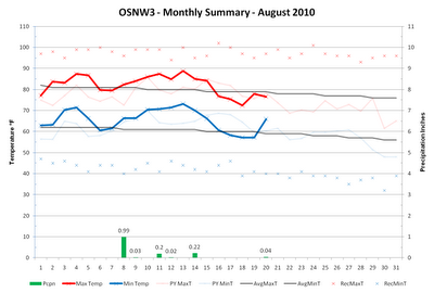
Ending with a week long dry spell, the summer of 2010 was still a deluge for the record books. What seemed like an inevitable feat, August kept OSNW3 out of the top spot for wettest summers of all-time in Oshkosh. Falling just 0.39" short of the 20.80" that fell in 1940 for a second place finish. However, officially, Oshkosh has broken the all-time record recording 0.61" more than the 1940 total at the official COOP site . More on that here and here . This summer also ended up being somewhat warm. The mean temperature for the three months at OSNW3 was 71.55°. Without a maximum temperature above 90° we still finished as the 12th warmest all-time in Oshkosh. OSNW3 recorded 55 days in the 80s and 62 nights in the 60s helping keep the mean temperature elevated. Forecast models are continuing the recent summer trends of warm and wet weather with predictions of above average for both to start the month of September. ( OSNW3 Weather Brief ) ( OSNW3 August Observations ) (O...
Creeping On All-Time Wettest Summer

Image
The middle part of August saw a welcomed cool down. A string of days recording below normal temps and low dew points made everyone much more comfortable. Unfortunately we were in Brooklyn, NY during this period to enjoy it. However, the daily weather descriptions left by the back-up OSNW3 observers, MarkMartin and Jeff Bollier, made my daydreams of cooler weather come true. I thank you gentlemen! WeatherScout also noticed and documented the great weather pattern. I am certain that this autumn will feel a bit cooler than usual even though the temps will be average due to our extremely hot and humid summer. My acclimation to dew points in the middle sixties is disheartening. ( OSNW3 Weather Brief ) ( OSNW3 August Observations ) (OSNW3 August 2010 Summary) (click on graph for the month summary data - it will open a new tab/window) ---- Oshkosh City Tournament Since the early 1930's, the city of Oshkosh has held an annual city golf tournament. I'm fortunate enough to have b...

Early August Heat & La Niña Trends

Image
August begins as expected for what the 2010 summer has been known for. Hot, humid, and wet. Things will continue this way for the next week or so until a change in the overall patten takes shape. Slightly below average temperatures are forecast for the period starting Aug 16 thru Aug 24. Above average precipitation will accompany the moderate temps. It is likely OSNW3 will surpass the wettest summer (Jun/Jul/Aug) in Oshkosh history total of 20.80". To date we are second with a total summer precipitation amount of 19.37". The data set for the precipitation rankings can be found here . Click here for the temperature rankings. ( OSNW3 Weather Brief ) ( OSNW3 August Observations ) (OSNW3 August 2010 Summary) (click on graph for the month summary data - it will open a new tab/window) ---- La Niña Conditions In Pacific The NWS Duluth put together a great entry about the current La Niña and what it means for the winter in the Northland. Below is the opening statement. Plea...

Summer Time

Image
July ends on a dry spell, so to speak. Only 0.20" in the last seven days. The two tenths round out the month completing the wettest July in Oshkosh's history. 11.84" were recorded here at OSNW3. More on the record rain in July from the NWS, here . The 6-10 and 8-14 day forecast calls for more above average temperatures and precipitation. **Addendum : Moister Than Most is a great "top news of the day" entry from the NWS in the Twin Cities. It references the many reasons for the heavy rainfall we have experienced this Summer. ( OSNW3 Weather Brief ) ( OSNW3 August Observations ) (OSNW3 August 2010 Summary) (click on graph for the month summary data - it will open a new tab/window) ---- CoCoRaHS : Summer Precipitation Comparison Precipitation can vary drastically from one backyard to the next. Especially during the Summer months when Thunderstorms drop locally heavy rains. OSNW3 has recorded three days this Summer with 24hr precipitation totals of over two ...

The Deluge That Is July 2010

Image
In just ten days OSNW3 has recorded another 5.15" of new rainfall. The amount is more than impressive, it's record breaking ( rankings ). Adding the 5.15" onto the 6.49" recorded during the first fifteen days of July puts us at 11.64" for the month through the 25th. The official precipitation record in Oshkosh for the month of July is 8.40". With a break from it today, Jul 25, temps and dewpoints have continued to be above average keeping things nice and hot around the area. OSNW3 is currently 2° above the official Oshkosh monthly mean for July. Many of the EAA campers are enduring the brunt of the record rainfall and above average temps. I personally hope things dry out and the moist air stays south to help make the fly-in a bit more suitable for being outdoors. ( OSNW3 Weather Brief ) ( OSNW3 July Observations ) (OSNW3 July 2010 Summary) (click on graph for the month summary data - it will open a new tab/window) ---- 2010 Summer Precip and Temp Cont...

A Wet First Half Of Summer

Image
Since Jul 5, OSNW3 has recorded 6.72" of new rainfall. Back to back six inch months have left the property very soggy with a most pungent smell of rotten in some areas. Most days have been hot and humid with abundant sunshine making all shaded spots very popular. This evening, Jul 18, was the most bearable of the past fourteen I can recall with a mostly cloudy sky. It was still humid, but the sun wasn't beating down. Long range forecasts call for more of the same but with a little less precipitation. The WxBrief now includes links for EAA aviation weather information. ( OSNW3 Weather Brief ) ( OSNW3 July Observations ) (OSNW3 July 2010 Summary) (click on graph for the month summary data - it will open a new tab/window) ---- 2010 Summer Precip and Temp Most people in the area are aware of the above average precipitation of late. Putting things in perspective, as of Jul 18, OSNW3's Summer (Jun,Jul,Aug) is currently ranked 16th for the all-time wettest in Oshkosh's...

July 14-15 Storms

Image
The Oshkosh area and most of our region experienced three rounds of heavy rain and thunderstorms during the 24hr period ending 7am Jul 15, 2010. Many daily records were broken and Oshkosh was no stranger, crushing the old daily record of 1.55" by 2+ inches. Here at OSNW3 we recorded a total of 3.67". This daily value is unofficially ranked 10th all-time in Oshkosh's history for largest 24hr precipitation total. (click image for a larger view) (Oshkosh 24hr precip greater than 3") ---- Some Photos With such heavy rain in short periods of time it is no wonder that the backyard flooded. The first round of rain came around 5pm dumping 1.02", the second round came around 8pm dumping 1.57", and finally the third round came around 12am dumping 1.08". Below are a few photos of the flooded yard and rain gauge. (Second Round Measurement) (Second Round Yard) (7:30am Gauge) (7:30am Yard) ---- Video and Radar Loop As the second round entered the area I was able...