Posts

Hello February

Image
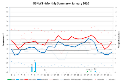
The past month has been abnormally quite. The snow pack has turned from fluffy goodness to a frozen slab of ice two inches thick. One thing that could be considered neat about the current frozen snow pack is that you can walk on top of it with out sinking in. I know, it's a reach for positivity. Hopefully February has something winterish in store for little ol oshkosh. The monthly summary for January can be viewed by clicking the graph below. ( OSNW3 January Observations ) (OSNW3 January 2010 Summary) (click on graph for the month summary data - it will open a new tab/window) ---- Weekly Snowfall We got a dusting of snow as the system that dropped all that rain moved on out. (Jan 26, 2010 - 0.3") ---- January Flop The lack of moisture during the month may not have been noticed by everyone in town due to the decent snow pack for most of the month and the countless days with a trace of snow, but it stared me down each and every morning. As a matter of fact, the past two Jan...

El Nino vs Old Man Winter

Image
The Oshkosh battle match between El Nino and Old Man Winter is tight. Old Man Winter is holding strong, like the veteran he is, but this seasons El Nino has stamina, delivering punch after punch bringing Old Man Winter to his knees. Currently as I type this we have a 3" snow pack which bodes well for the old man. Forecasts are calling for a pattern change that will put the El Nino blows on retreat. Temps are predicted to fall back to average levels and with a snow depth greater than an inch there is little doubt winter will fail to continue ( WSD ). ( OSNW3 January Observations ) (OSNW3 January 2010 Summary) (click on graph for the month summary data - it will open a new tab/window) ---- Winter Season Duration As our latest bout with El Nino comes to a close the once wintry scene around Oshkosh is now a dirty sloppy mess. I am relatively confident that a mid-season flip to Spring, like the 2005/06 winter season , is not in our future. Winter will continue. The OSNW3 winter ...

Half Full or Half Empty

Image
As the meteorological winter nears the half way point, our area is feeling the effects of some moderated Pacific air. The current pattern is keeping us mild and dry. It's possible the genesis of the weather is El Nino related. Regardless of it's origins, it's a love/hate relationship. Fortunately for some, the warm air has been coupled with mostly cloudy skies keeping snow melt to a minimum. We are currently maintaining a 6" snowpack here, but it is likely to shrink some more in the coming days. ( OSNW3 January Observations ) (OSNW3 January 2010 Summary) (click on graph for the month summary data - it will open a new tab/window) ---- Weekly Snowfall Not much happening in the snow department this past week. We had little more than a dusting back on the 11th. (Jan 11, 2010 - 0.1") ---- OSNW3 2009 Climate Summary Looking back to what was 2009 a couple things stand out. The overall mean temp for the year exactly matched the average mean temp for Oshkosh. Preci...

Location, Location, Location

Image
The big Arctic blast that has been in the news lately has bypassed our region. We can thank the Great Lakes of Superior and Michigan for that. Being " locked-in " so to speak, kept us much warmer than most, if not all, of the states west and south of us in the Midwest. Bitter cold up in Duluth, MN , in Clayton, WI , and even as far south as Fulton, MO . Temperatures around here have been seasonable and for the month we are just a degree below the average mean. The middle of last week saw a decent sized snow storm move through the region dumping most of the snow in Southeast WI . As for next week, forecasts call for a warm up. See the WxBrief for more details. ( OSNW3 January Observations ) (OSNW3 January 2010 Summary) (click on graph for the month summary data - it will open a new tab/window) ---- Weekly Snowfall Each day this past week saw at least a Trace of snow. Seven days in a row. It's always a pleasure for us here at OSNW3 to see snow falling from the sky...

Once in a Blue Moon

Image
As another snowy December came to a close, the lunar cycle displayed it's second full moon of the month. For the first time in almost 20 years, there was a " Blue Moon " on New Year's Eve. While 2010 begins, forecasts call for a dry and temperate pattern to evolve for the region, we'll see. ( OSNW3 January Observations ) (OSNW3 January 2010 Summary) (click on graph for the month summary data - it will open a new tab/window) ---- December Climate Summary OSNW3 recorded 15 days with accumulating snowfall this December ( Days With Measurable Snow ). Over half of the entire months snow fell in two of those days, however ( Dec 8-9 ). The month ended with a total of 19.1" of snow, which is the 12th highest monthly total since 1893, and for the fourth consecutive year here at OSNW3, December has topped the average monthly precipitation average ( Annual Precipitation ). Temperatures wavered as the month progressed, but when it was all said and done, the monthly me...

It's Dark Outside

Image
Max temperatures hovered around average for the most part this past week. With the warmer temps, though, we did see four measurable snowfalls. Nothing major as three of the four were under an inch. We are currently 4.2" above the December monthly snowfall average and for the third consecutive year have exceeded that average. Last December Oshkosh broke an all-time monthly snowfall record, recording 35.6" here at OSNW3 and 33.7" officially at the WWTP. An amazing 18 days recorded measurable snowfall ( Days with Measurable Snowfall ), and comparing last December to this December we are two days behind. Up to this point, last December had 10 days with measurable snowfall while this December has had only 8, which is still above the Oshkosh average (6.1 days). ( OSNW3 December Observations ) (OSNW3 December 2009 Summary) (click on graph for the month summary data - it will open a new tab/window) ---- Weekly Snowfall Each of the four snowfalls last week provided just en...

December's Big Hand

Image
We have to give a big hand to the 12 beginning days of December 2009. In these 12 days we here at OSNW3 have experienced a plethora of seasonal firsts. First accumulation (Dec 3), first inch (Dec 7), our first snowstorm and the first day of winter (Dec 12) have all taken place. The first snowfalls came a week or two late, but the first snowstorm and winter were near "normal" according to archived data observed at OSNW3 ( Firsts & Lasts ). ( OSNW3 December Observations ) (OSNW3 December 2009 Summary) (click on graph for the month summary data - it will open a new tab/window) ---- Weekly Snowfall The past week was an exciting one for snowfall. The beginning of the week we were still wishing for snow. As of today we've got a fairly fresh base, seven inches deep. As for what is to come next in Oshkosh, follow these guys ( Tim , Derek , & Chris ) and you'll have an idea of the days ahead. If what they're reporting sparks an interest then check the OSNW3...