Posts

Showing posts from February, 2010

Meteorological Winter is Complete

Image
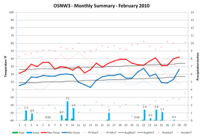
When the Western Great Lakes region thinks about an El Nino winter, we think warm and dry conditions. Since the beginning of the meteorological winter season that isn't exactly how it's been. February of 2010 felt like it was being affected by El Nino. Temperatures hovered above average (+2.4°F) without any major swings up or down, but in the end, it was above average in precipitation (+0.04") and snowfall (+5.1"), which are not typical characteristics. Sticking with that trend is the meteorological winter of 2009-2010 as it has proven that what is known and predicted of El Nino does not always come to fruition. ( OSNW3 February Observations ) (OSNW3 February 2010 Summary) (click on graph for the month summary data - it will open a new tab/window) ---- Weekly Snowfall It was an active week for snowfall. Three days of measurable snowfall totaling 2.9" along with another day with a Trace. A nice way to end February. Snowfall Days With Measurable Snow (Feb 23, 20

El Nino Bashing

Image
Lately the snowfall around here has been of an oddity. I somewhat feel like the area has shifted into another climate classification zone. The snow falls, accumulates, and then it melts. If the observer isn't around to make an observation just as the snow stops, it'll be gone within a few hours. Maximum temperatures have been above 30°F for the past 8 days, and with the strength of the February sun, all the ingredients are there to quickly melt away any new snow. As of the morning observation on Feb 22, we have a 6" snow depth . Maintaining that depth until the end of the month seems impossible, however there are chances of snow Tue and Wed that may help prolong it. ( OSNW3 February Observations ) (OSNW3 February 2010 Summary) (click on graph for the month summary data - it will open a new tab/window) ---- Weekly Snowfall With two snows succumbing to the situation mentioned above, we did have a couple of snows actually stick around long enough to be measured at OSNW

Longest.Drive.Ever.

Image
I was out of town for work this past week. Down south in Monroe, LA. Working in Crossett, AR. As most of you know it snowed down there. More on my experience later. Back home, here at OSNW3, a Winter Storm Warning was in effect early in the week. In my absence my wife and daughter took over the observing responsibilities. They did an awesome job during the storm... being in the elements twice a day taking observations documenting a fluffy snowfall the first round and a wind driven snowfall the second round. I was available via phone support but none was needed. Over the years the OSNW3 precipitation observing crew has become a devoted and reliable bunch! ( OSNW3 February Observations ) (OSNW3 February 2010 Summary) (click on graph for the month summary data - it will open a new tab/window) ---- Weekly Snowfall Oshkosh was under a Winter Storm Warning early this week. As the storm moved closer to the area, two separate bands of Lake Effect snow developed off of Lake

The Month Of The Pearl

Image
With a 2"+ snowfall to begin last week and a moderate snowfall forecast for early this week, the first two weeks of February will out total the entire month of January in the snowfall department. It will be a welcomed change of events here at OSNW3. ( OSNW3 February Observations ) (OSNW3 February 2010 Summary) (click on graph for the month summary data - it will open a new tab/window) ---- Weekly Snowfall Light snow made an appearance early in the week. It was a welcomed site and I even got to use the wovel again. Later in the week we had another light snowfall, however the daytime temps were above freezing so the snow never had a chance to accumulate. (Feb 2, 2010 - 1.3") (Feb 3, 2010 - 0.9") ---- East Coast Snowpocalypse A good friend of ours lives near Washington DC. He's from Green Bay and schooled in Houghton, MI so he's had his fair share of large scale snow storms and LES events. This most recent blast in DC ranks as his "second worst snowstorm&