Meteorological Winter is Complete
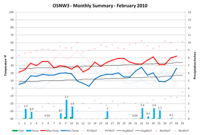
When the Western Great Lakes region thinks about an El Nino winter, we think warm and dry conditions. Since the beginning of the meteorological winter season that isn't exactly how it's been. February of 2010 felt like it was being affected by El Nino. Temperatures hovered above average (+2.4°F) without any major swings up or down, but in the end, it was above average in precipitation (+0.04") and snowfall (+5.1"), which are not typical characteristics. Sticking with that trend is the meteorological winter of 2009-2010 as it has proven that what is known and predicted of El Nino does not always come to fruition. (OSNW3 February Observations)
(OSNW3 February 2010 Summary)
(click on graph for the month summary data - it will open a new tab/window)
----
Weekly Snowfall
It was an active week for snowfall. Three days of measurable snowfall totaling 2.9" along with another day with a Trace. A nice way to end February.
Snowfall
Days With Measurable Snow
(Feb 23, 2010 - 0.3")

(Feb 24, 2010 - 1.4")


(Feb 25, 2010 - 1.1")

(Feb 27, 2010 - 0.1")

----
Meteorological Winter Is Complete
We've broken the El Nino mold with above average precipitation and snowfall marks this 2009-2010 meteorological winter season. Temperatures were on target as far as El Nino is concerned, so I suppose it comes down to a draw between OMW and ELN for who won the battle this season.
(OSNW3 2009-2010 Meteorological Winter vs Oshkosh Average)

----
2009-2010 Meteorological Winter Precip Comparison
As the meteorological winter closes I'd like to share a comparison of "active" CoCoRaHS observer data from Winnebago County. We have three observers in Oshkosh and one in Omro. I've also included the official NWS station for Oshkosh in the comparison. A map with each location is below.¹ From the data it would seem that the western portion of Winnebago County has seen more snow and precipitation than the eastern portion. The Omro station comes in with the highest precipitation and snow total this meteorological winter. Please click the chart below for the comparison data set. It will open up in a new page/tab.
(Comparison Chart)

(Observer Locations)

¹ Currently there are no CoCoRaHS observers in the northern areas of the county. There are two NWS observers in Neenah but that data is unobtainable via the Internet as far as I know.
----
Late Winter Driving In Wisconsin
This past week we had a decent snow and blowing snow event in Northeast and East-central WI. I was lucky enough to have traveled to Sheboygan the day of the more intense snowfalls and winds. As any normal weather enthusiast I had my camera ready to document my travels. The photo below is of the western sky on my drive home early in the evening. The link below is of my early morning drive to Sheboygan when the winds were whipping and the snow was blowing. It's worth a view as I am blinded by a plows snow for a few seconds. Turn your volume down, though, as I had my car stereo fairly loud. More photos located here.
(Looking West - Hwy 23 - Near St. Cloud, WI)

Video - Traveling East To Sheboygan
----
Front Of House
Two weeks a row where the FOH was taken during a snowfall. While the meteorological winter is over, winter at OSNW3 continues. Winter at OSNW3 began on Dec 12, 2009 and has maintained itself thus far, which is 79 days and counting. To see the OSNW3 Winter Duration graph, please click here. To see the timelapse of the webcam please click here and choose "slideshow".
(FOH - Feb 28, 2010)

(OSNW3 February 2010 Summary)
(click on graph for the month summary data - it will open a new tab/window)
----
Weekly Snowfall
It was an active week for snowfall. Three days of measurable snowfall totaling 2.9" along with another day with a Trace. A nice way to end February.
Snowfall
Days With Measurable Snow
(Feb 23, 2010 - 0.3")

(Feb 24, 2010 - 1.4")


(Feb 25, 2010 - 1.1")

(Feb 27, 2010 - 0.1")

----
Meteorological Winter Is Complete
We've broken the El Nino mold with above average precipitation and snowfall marks this 2009-2010 meteorological winter season. Temperatures were on target as far as El Nino is concerned, so I suppose it comes down to a draw between OMW and ELN for who won the battle this season.
(OSNW3 2009-2010 Meteorological Winter vs Oshkosh Average)

----
2009-2010 Meteorological Winter Precip Comparison
As the meteorological winter closes I'd like to share a comparison of "active" CoCoRaHS observer data from Winnebago County. We have three observers in Oshkosh and one in Omro. I've also included the official NWS station for Oshkosh in the comparison. A map with each location is below.¹ From the data it would seem that the western portion of Winnebago County has seen more snow and precipitation than the eastern portion. The Omro station comes in with the highest precipitation and snow total this meteorological winter. Please click the chart below for the comparison data set. It will open up in a new page/tab.
(Comparison Chart)
(Observer Locations)
¹ Currently there are no CoCoRaHS observers in the northern areas of the county. There are two NWS observers in Neenah but that data is unobtainable via the Internet as far as I know.
----
Late Winter Driving In Wisconsin
This past week we had a decent snow and blowing snow event in Northeast and East-central WI. I was lucky enough to have traveled to Sheboygan the day of the more intense snowfalls and winds. As any normal weather enthusiast I had my camera ready to document my travels. The photo below is of the western sky on my drive home early in the evening. The link below is of my early morning drive to Sheboygan when the winds were whipping and the snow was blowing. It's worth a view as I am blinded by a plows snow for a few seconds. Turn your volume down, though, as I had my car stereo fairly loud. More photos located here.
(Looking West - Hwy 23 - Near St. Cloud, WI)

Video - Traveling East To Sheboygan
----
Front Of House
Two weeks a row where the FOH was taken during a snowfall. While the meteorological winter is over, winter at OSNW3 continues. Winter at OSNW3 began on Dec 12, 2009 and has maintained itself thus far, which is 79 days and counting. To see the OSNW3 Winter Duration graph, please click here. To see the timelapse of the webcam please click here and choose "slideshow".
(FOH - Feb 28, 2010)

Bring on Spring! My forecast has Sunshine for me everyday with highs near 40 everysingle day! Our snowpack will really take a hit this week.
ReplyDeleteLot's of meteorological "brain candy" on today's post, OSNW3! I wish I had more time to dig through the data. I haven't compiled my monthly data as of yet, but I know that our mean temperature was below average. I'll get the data posted today hopefully.
ReplyDelete311 and blowing snow. I never thought the two could blend so well together. You proved me wrong! :o) Thanks for the video!
D, without analyzing a long range forecast I can feel it in my bones that winter is not over. For me, Spring can hold off another month until I start getting the fever. For you though, I can understand with your green thumb it can't come any sooner! :)
ReplyDeleteWxWatcher, yeah I typed "meteorological" way too many times in this entry. :)
OK, so I'm jealous what with your snow on the ground and all. Today we had some early morning fog which cleared to a really nice day.
ReplyDeleteI fell spring in the air. I do hope we keep getting these little rain events – good for spring and summer.
Hi Bob, looking at the long range forecasts I don't think our snow will last through mid March. I was a bit over zealous when I made my original guesses on when certain ending events would take place. I haven't felt Spring in the air over here just yet, and I am hoping I don't for a couple more weeks as it would only be a tease.
ReplyDeleteOne man's spring is another man's winter... lol. I hope you enjoy a quasi-spring while you're down.
ReplyDeleteOur Japanese Magnolias are actually blooming...
ReplyDelete