Posts

Showing posts with the label Oshkosh Snowstorm

Post Winter Storm Report - Apr 19
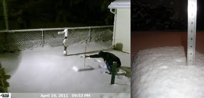
Image
The snow started about 11am on Apr 19 and intensified as the day progressed. The afternoon brought many bolts of lightning and claps of thunder. By the time I was able to leave Holland, WI my car was covered in about six inches of fresh heavy wet snow. The drive back to Oshkosh was long and tedious as roads were snow covered. Winds were whipping as well enhancing the low visibilities. I was able to snap a few photos in Holland and get a measurement once I got home. At the time of observation the wind was gusting considerably and the snow was winding down. A radar loop and a webcam time lapse can be found by clicking the links. A few photos of the storm are located here . Precip: 1.23" Snow: 6.4" Snowdepth: 6" (Apr 19, 2011 - 6.4" - 9:53pm) (Apr 19, 2011 - Rain Gauge) (Apr 19, 2001 - Weight Of Snow) (Apr 19, 2011 - Holland, WI - 1pm) (Apr 19, 2011 - Holland, WI - 7pm) ---- April Snow Stats I quickly gathered the all-time greatest snowfalls in Oshkosh for the ...

The Great Lakes Cyclone IV

Image
Our neighbors across the street, the owners of the TAS , were raking their front lawn this past Sunday. I stepped out of my front door and mentioned to them that it is to early for raking as I still had snow in my front yard. I also mentioned that a storm was coming and there will soon be snow covering the ground again. Either way, they are ahead of the spring clean up game and it inspired me later that afternoon to finish trimming a tree and picking up random small pieces of trash that some how float into my yard. It was a well deserved clean up after 95 days of winter. Winter officially ended at OSNW3 on Mar 22. It doesn't look like it at the moment with the fresh coating of snow or feel like it with temps dipping into the low teens at night barely making it above freezing for highs the next day. Adding the fact that we are locked into this pattern for another week or more will make it feel like winter even more. However, a warm up is coming. Plan for the second week of ...

Post Snowstorm Recap - Dec 11-12, 2010

Image
Anyone that follows the LRC knew this storm was coming. Most forecast models were confused throughout the duration. Regardless, the outcome was extreme. Our travel plans for the weekend were canceled and we stocked up on some extra foods as we knew we'd be snowed in for up to 24 hours. I even purchased a new shovel to compliment the wovel. I will be uploading a Picasa web album and videos on YouTube as time allows. Also, I am including a link to the Post Storm Survey. Participation is highly encouraged. PSS Site . Direct link to the PSS Survey for this storm. December climatology thus far can be found here . Other winter data can be found here by scrolling down to the "Winter History" section. A radar loop of the storm up until the posting of this entry can be found here . Mark your calendars for the third iteration of the 'Great Lakes Cyclone', Jan 27-28*. *(the storm recurred on Feb 1-2 sliding a bit south and grazing OSNW3) Winnebago County ...