Posts

Showing posts with the label February Snowfall

Meteorological Winter is Complete
Image
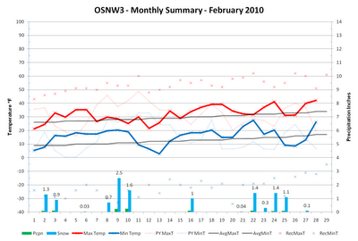
When the Western Great Lakes region thinks about an El Nino winter, we think warm and dry conditions. Since the beginning of the meteorological winter season that isn't exactly how it's been. February of 2010 felt like it was being affected by El Nino. Temperatures hovered above average (+2.4°F) without any major swings up or down, but in the end, it was above average in precipitation (+0.04") and snowfall (+5.1"), which are not typical characteristics. Sticking with that trend is the meteorological winter of 2009-2010 as it has proven that what is known and predicted of El Nino does not always come to fruition. ( OSNW3 February Observations ) (OSNW3 February 2010 Summary) (click on graph for the month summary data - it will open a new tab/window) ---- Weekly Snowfall It was an active week for snowfall. Three days of measurable snowfall totaling 2.9" along with another day with a Trace. A nice way to end February. Snowfall Days With Measurable Snow (Feb 23, 20...

The Month Of The Pearl

Image
With a 2"+ snowfall to begin last week and a moderate snowfall forecast for early this week, the first two weeks of February will out total the entire month of January in the snowfall department. It will be a welcomed change of events here at OSNW3. ( OSNW3 February Observations ) (OSNW3 February 2010 Summary) (click on graph for the month summary data - it will open a new tab/window) ---- Weekly Snowfall Light snow made an appearance early in the week. It was a welcomed site and I even got to use the wovel again. Later in the week we had another light snowfall, however the daytime temps were above freezing so the snow never had a chance to accumulate. (Feb 2, 2010 - 1.3") (Feb 3, 2010 - 0.9") ---- East Coast Snowpocalypse A good friend of ours lives near Washington DC. He's from Green Bay and schooled in Houghton, MI so he's had his fair share of large scale snow storms and LES events. This most recent blast in DC ranks as his "second worst snowstorm...

February Snowfall

Image
As much of February was, the temperatures this past week were the same, above average. A quality late season snow storm rolled through late in the week bringing some weather excitement to the area. Thundersnow was reported in many areas in Northeast WI. A phenomenon not experienced often around here. I personally did not get to see or hear it, but a few of my friends and family did. What I did experience though, was pouring sleet for over an hour. It clogged my roof drainage and our roof leaked for the first time. Click here for the storm recap. ( OSNW3 February Observations ) (Temp Comparison 2009 / 2009 | Feb 1 - 28) Max temp: 25.0 / 32.1 / +7.1 Min temp: 9.8 / 14.9 / +5.1 (February 2009 Precipitation) 2009 Monthly Total Precip.. 2.04" Snow.... 11.0" Oshkosh Average Precip.. 1.09" Snow.... 7.2" Departure Precip.. +0.95" Snow.... +3.8" ---- February Snowfall The monthly snowfall total here at OSNW3, for the month of February, was above the Oshko...