Posts

Showing posts with the label Oshkosh Flooding

July 2 - Oshkosh Wx Spotters Unite!

Image
A locally grown complex of thunderstorms in NW Outagamie county organized late in the afternoon on July 2. Gaining strength as it moved south into Winnebago county the strength of the storm was evident as it reached peak intensity directly over Oshkosh. (Radarloop Jul 2, 2012) Hail, strong wind gusts, and street flooding were the most common reports from the eleven storm spotter reports made to the National Weather Service in Green Bay. A condensed version of the NWS-GRB Oshkosh reports are located here . Fellow storm spotter, Mark Martin, had the opportunity to snag a hail stone and measure it. His hail measured just about an inch, but there were reports of larger hail measuring 1.5 inches. A photo of Mark's hail is below. I recovered a quarter sized hail stone at OSNW3 but was unsuccessful in getting a quality photo of it. I did get pelted in the head during the act of retrieval. I will admit that it hurt and that I should not have gone out to retrieve it in the first p...

When It Rains, It Pours

Image
The words below were originally written for The Oshkosh Northwestern - Monthly Weather Report ---- The old saying goes “when it rains, it pours” and that was exactly the case for how May of 2012 transpired. Seven of the first thirteen days recorded measurable precipitation. These seven days accounted for more than 80% of the monthly rainfall total which included the deluge that occurred on May 2-3. The May 2-3 rainfall became the largest daily rainfall in the month of May and also became the 6th all-time largest daily rainfall in Oshkosh history. Two of the four precipitation observation stations in the greater Oshkosh area recorded over 7 inches for the month pushing the monthly total into second place all-time for the month of May. The top spot belongs to May of 2004 when 9.04 inches were recorded. Oshkosh daily observations date back to 1893. Greater Oshkosh May 2012 Precipitation Totals 5.84", Oshkosh 5.2 N 7.64", Oshkosh 1.3 NNE 7.99", Oshkosh WWTP (NWS)...

Because Every Drop Counts

Image
The words below were originally written for The Greater Oshkosh Editions of the Scene Newspaper ---- Shortly after I moved to Oshkosh in 1996 I realized how arousing it would become living here, on the water. Each day I admire our water landscape feeling truly fortunate to call Oshkosh home. The great amount of water resources that border or flow through our city demand respect and continual maintenance and care. Each time rain falls from the sky or a snowpack melt, the water that runs off our roofs, driveways, and yards flow into storm water sewers and creeks that eventually flow directly into the Fox River and Lake Winnebago. There are an outstanding amount of factors that contribute to a storm water management system. However, ultimately it is the amount of rain that falls on a particular area that brings the land use and soil types to a cohesive head preventing storm water runoff from entering our waterways. The city of Oshkosh uses precipitation data to effectively analyze ...

Oshkosh's Third "10-Year" Storm In Four Years

Image
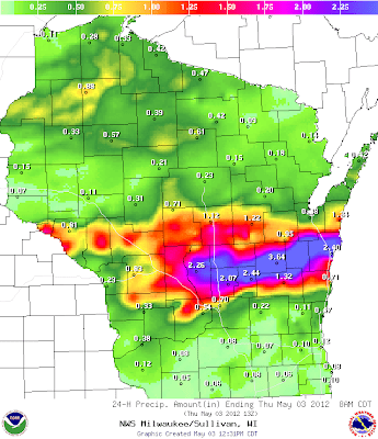
Early morning and into the afternoon on May 3 Oshkosh endured some hefty rainfall amounts. Thunderstorms trained over the city which kept the populous enthralled to sights of bright lightning strikes and sounds of deep thunder roars and pounding rain. (Winnebago County Precipitation Totals) 1.34 MNSW3 MENASHA-JEFFERSON 2.08 NAHW3 NEENAH-EAST 1.55 WNCW3 WINNECONNE-5NW-LK 3.56 OMSW3 OMRO-SOUTHEAST 3.26 OMWW3 OMRO-2 3.10 OOHW3 OSHKOSH-5 4.12 OSNW3 OSHKOSH-NORTH 2.76 OSH OSHKOSH-AIRPORT 4.15 OKHW3 OSHKOSH-WWTP 3.35 OOSW3 OSHKOSH-6 (Wisconsin Statewide Precipitation Totals) Travel around town was limited as high water made roads impassable rerouting traffic onto the path less traveled. The new surroundings brought the situation into light. Many citizens, again, were hit very hard by the flooding rains. Little Lake Waugoo re-fills for the first time in 2012.  #wiwx   twitter.com/streetwiseosh/… — Jeff Bollier (@streetwiseosh)  May 3, 2012 Looks like no recess ...

July 14-15 Storms

Image
The Oshkosh area and most of our region experienced three rounds of heavy rain and thunderstorms during the 24hr period ending 7am Jul 15, 2010. Many daily records were broken and Oshkosh was no stranger, crushing the old daily record of 1.55" by 2+ inches. Here at OSNW3 we recorded a total of 3.67". This daily value is unofficially ranked 10th all-time in Oshkosh's history for largest 24hr precipitation total. (click image for a larger view) (Oshkosh 24hr precip greater than 3") ---- Some Photos With such heavy rain in short periods of time it is no wonder that the backyard flooded. The first round of rain came around 5pm dumping 1.02", the second round came around 8pm dumping 1.57", and finally the third round came around 12am dumping 1.08". Below are a few photos of the flooded yard and rain gauge. (Second Round Measurement) (Second Round Yard) (7:30am Gauge) (7:30am Yard) ---- Video and Radar Loop As the second round entered the area I was able...