First Accumulation
This past week max temps remained below average each day. Along with the cool temps came OSNW3's first accumulating snow however. It was only a tenth of an inch, but none the less (daily video). The large Lake Effect events that dumped several inches in the UP and Northern WI only ushered in clouds and maybe a flurry from time to time for us down here as we remained mainly sunny and windy.
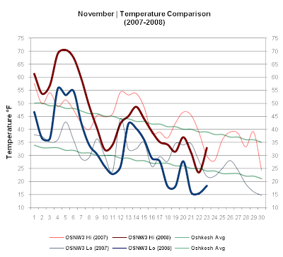
(OSNW3 November Observations)
(Temp Comparison 2007 / 2008 | Nov 1 - 23)
Max temp: 45.9 / 45.1 / -0.7
Min temp: 32.7 / 32.7 / +0.0
(November 2008 Precipitation)
2008 Monthly Total
Precip 0.87
Snow 0.1
Oshkosh Average
Precip 2.51
Snow 4.0
Departure
Precip (1.64)
Snow (3.9)

----
Monday, Nov 17
I witnessed about a half inch of snow accumulate from a short lived snow squall. Start to finish the squall lasted about 30 minutes. I was fortunate enough to have the time to document my first taste of Winter weather this season. Photo and video below.
(Neenah, WI - Nov 17, 2008)

(Neenah, WI - Nov 17, 2008)
Back home in Oshkosh, at OSNW3, my wife Alicia took a measurement as the snow ended. 0.1" had fallen here. (radar loop)

----
Front Of House
(FOH - Nov 23, 2008)

----
OSNW3 Website Update
With new navigation to the Snowcore Observations comes the Seasonal Snowdepth Loops. Check out both products by navigating to the OSNW3 Observations page, then clicking on "Seasonal Snowcore". Also the OSNW3 Photo Album has been updated. OSNW3 Winter 2008-2009 snapshots are underway. Previous Winter snapshots: Winter 2006-2007 | Winter 2007-2008
----
OSNW3 Climate Tidbits
The min temp on Nov 18 was 18.1 while the max was 31.5. With that said, the last time the min dipped below 20 was on Mar 17 when it dropped to 19.8 and the last time the max temp stayed below freezing was also on Mar 17 when it reached 29.8, a 247 day duration for both events.
Winter around here seems to last forever for some, but when you look at the amount of days in between Winter weather, it makes me appreciate our wonderful Winter season even more.
----
Green Bay Snowfall Review Confirms Top Snowiest Winters
The Climate Program Leader at the National Weather Service (NWS) office in Green Bay conducted a thorough review of snowfall data for the seasons of 1886-87 to 1890-91 to ensure the veracity of the data.
Entire story here.
----
Alberta Meteor Sighting
For the few that may have not heard of this yet...
Video
Article

(OSNW3 November Observations)
(Temp Comparison 2007 / 2008 | Nov 1 - 23)
Max temp: 45.9 / 45.1 / -0.7
Min temp: 32.7 / 32.7 / +0.0

(November 2008 Precipitation)
2008 Monthly Total
Precip 0.87
Snow 0.1
Oshkosh Average
Precip 2.51
Snow 4.0
Departure
Precip (1.64)
Snow (3.9)

----
Monday, Nov 17
I witnessed about a half inch of snow accumulate from a short lived snow squall. Start to finish the squall lasted about 30 minutes. I was fortunate enough to have the time to document my first taste of Winter weather this season. Photo and video below.
(Neenah, WI - Nov 17, 2008)

(Neenah, WI - Nov 17, 2008)
Back home in Oshkosh, at OSNW3, my wife Alicia took a measurement as the snow ended. 0.1" had fallen here. (radar loop)

----
Front Of House
(FOH - Nov 23, 2008)

----
OSNW3 Website Update
With new navigation to the Snowcore Observations comes the Seasonal Snowdepth Loops. Check out both products by navigating to the OSNW3 Observations page, then clicking on "Seasonal Snowcore". Also the OSNW3 Photo Album has been updated. OSNW3 Winter 2008-2009 snapshots are underway. Previous Winter snapshots: Winter 2006-2007 | Winter 2007-2008
----
OSNW3 Climate Tidbits
The min temp on Nov 18 was 18.1 while the max was 31.5. With that said, the last time the min dipped below 20 was on Mar 17 when it dropped to 19.8 and the last time the max temp stayed below freezing was also on Mar 17 when it reached 29.8, a 247 day duration for both events.
Winter around here seems to last forever for some, but when you look at the amount of days in between Winter weather, it makes me appreciate our wonderful Winter season even more.
----
Green Bay Snowfall Review Confirms Top Snowiest Winters
The Climate Program Leader at the National Weather Service (NWS) office in Green Bay conducted a thorough review of snowfall data for the seasons of 1886-87 to 1890-91 to ensure the veracity of the data.
Entire story here.
----
Alberta Meteor Sighting
For the few that may have not heard of this yet...
Video
Article
I can see in your camera is looks like you might have gotten more then an inch! did you see the Metor ? what a cool story!
ReplyDeleteDerek, I certainly did not see the meteor, only found out about it from a friend. It's super awesome! Yeah, I posted on your cbox, that we indeed received almost 5" of snow overnight. You can see more data of the overnight by checking out the links I included on you cbox post.
ReplyDeleteHAHA! Derek, I totally spaced and pressed post when I was writing the response to your comment. You see, I was going to link something and when I do that I compose the text in the blog entry editor because it's just easier... but then decided not too. Anyways, I didn't intend to create another blog entry. :)
ReplyDeleteYes, we got a good dose of snow last night... however I fear the sun will melt most of what we have by Turkey day. You may get some snow tonight, however... eh?!