Posts

Showing posts with the label Snowfall

2012-13 Winter Season: First Inch Of Snow
Image
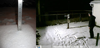
The Oshkosh average date for the first one inch snowfall is Dec 2. This year it occurred on Dec 9. We've been observing precipitation at OSNW3 since Nov 2006 and we've recorded a first one inch snowfall on Dec 9 twice, first time back in 2010. It is the latest date we've recorded in our six winters. Earliest date is Nov 9 which occurred last year.  All the winter "firsts and lasts" at OSNW3 can be found here . ...WINNEBAGO COUNTY... 2 WSW OMRO (752 FT)(COCORAHS)          3.9 IN OMRO - 2 SW (761 FT)(UCOOP)                3.9 IN 3 S WITTMAN FIELD (794 FT)(COCORAHS)       3.5 IN OSHKOSH 6 S (794 FT)(UCOOP)                3.5 IN 2 NNE OSHKOSH (774 FT)(COCORAHS)           2.6 IN OSHKOSH-NORTH (773 FT)...

Still Lacking True Winter Conditions

Image
In the last blog entry I discussed the fact that winter may finally be making an appearance in 2011-12. All we needed was one more day of ' winter season duration ' criteria to have fully transitioned, but alas that did not happen. The maximum temperature recorded on Jan-23 for the previous 24 hours was above freezing and in a 'non winter fashion' precipitation fell in the form of liquid. The good news is we should expect two notable storm systems to make their way towards the region during the first half of February. The question is, will the precipitation make into WI and will it be rain or snow? For more information on the storm systems please see the OSNW3|LRC blog entry " Weather Event Forecasting - First Half Of February ". ( OSNW3 Weather Brief ) ( OSNW3 January Observations ) (OSNW3 January 2012 Summary) (click on graph for the month summary data - it will open a new tab/window) ---- Weekly Snowfall Since Jan-22 we've recorded 4 day...

January 12 Snowfall Recap

Image
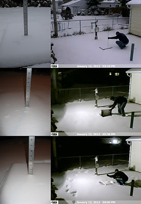
A Winter Storm Watch was in effect for the entire area Jan-12, 2012. It became a significant event because it was our first chance at more than an inch of snow since Nov-9, 2011. The snow began around 7am and lightly came down for the entire day. A moderate push of snow occurred mid-afternoon but did not last for more than a hour. Snowfall rates averaged a little over a quarter inch per hour throughout the 14-15 hour duration of snowfall. Flakes were small, light and wind blown. Here at OSNW3 we measured a storm total of 4.0 inches. (Jan 12, 2012 - 4.0") (Regional Radarloop - Jan 12, 2012) Totals from around Oshkosh range from 4.0 to 4.2 inches. A very consistent snowfall as snowfall often varies a bit from north to south in Oshkosh. The consistency continues throughout Winnebago county and the rest of the area. See image below for state wide totals (click image for more details). Don't be deceived by the purple up by Ironwood, it should really be red to orang...

Location, Location, Location

Image
The big Arctic blast that has been in the news lately has bypassed our region. We can thank the Great Lakes of Superior and Michigan for that. Being " locked-in " so to speak, kept us much warmer than most, if not all, of the states west and south of us in the Midwest. Bitter cold up in Duluth, MN , in Clayton, WI , and even as far south as Fulton, MO . Temperatures around here have been seasonable and for the month we are just a degree below the average mean. The middle of last week saw a decent sized snow storm move through the region dumping most of the snow in Southeast WI . As for next week, forecasts call for a warm up. See the WxBrief for more details. ( OSNW3 January Observations ) (OSNW3 January 2010 Summary) (click on graph for the month summary data - it will open a new tab/window) ---- Weekly Snowfall Each day this past week saw at least a Trace of snow. Seven days in a row. It's always a pleasure for us here at OSNW3 to see snow falling from the sky...