Winter Storm Warning - Jan 30
Call it MAGNUS, call it DENISE, any way you slice it, there is a good chance of snow on the horizon. The National Weather Service in Green Bay has issued a Winter Storm Warning for the area.
----
Measurements (4)
----
Jan 30, 2013 @ 16:59
Two measurement to make a 16:59 total of 1.3" more. Light snow is currently falling. Snow is light, fluffy. Temperatures are slowly dropping.
1.3" - New Snow
8.2" - Total Storm Snow
Current Snow Depth - 8"
(Jan 30, 2013 - 14:44 - 0.9")

(Jan 30, 2013 - 16:59 - 0.4")

(The First Shoveling)

(The Second Shoveling)

(US Radar - 5PM)

----
Jan 30, 2013 @ 11:08
2.2" more measured at 11:08. Moderate to heavy snow continues to fall. Snow is still very thick and packy. Gusty winds have now been introduced to the equation.
2.2" - New Snow
3.9" - Total Storm Snow
Current Snow Depth - 4"
(Jan 30, 2013 - 11:08 - 2.2")

(Looking West - Congress Ave - 11AM)

(Looking Southwest - 11AM)

(US Radar - 11AM)

----
Jan 30, 2013 @ 08:04
1.7" more measured at 08:04. Moderate snow began a few hours prior. Moderate snow continues to fall. Snow is very packy.
1.7" - New Snow
1.7" - Total Storm Snow
Current Snow Depth - 2"
(Jan 30, 2013 - 08:04 - 1.7")

(Looking West - Congress Ave - 8AM)

(US Radar - 8:15AM)

----
(NWS-GRB Forecast Snowfall)

(JPoublonWX Forecast Snowfall)

----
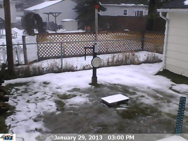
The morning of Jan-29 OSNW3 had 2 inches of snow depth. The afternoon of Jan-29 it sat as 2 inches of slush and/or standing water. It could very well become an ice rink while the temperatures drop and the snow begins to fall. Good times. Updates as the storm nears and progresses forthcoming.
----
Measurements (4)
----
Jan 30, 2013 @ 16:59
Two measurement to make a 16:59 total of 1.3" more. Light snow is currently falling. Snow is light, fluffy. Temperatures are slowly dropping.
1.3" - New Snow
8.2" - Total Storm Snow
Current Snow Depth - 8"
(Jan 30, 2013 - 14:44 - 0.9")

(Jan 30, 2013 - 16:59 - 0.4")

(The First Shoveling)

(The Second Shoveling)

(US Radar - 5PM)

----
Jan 30, 2013 @ 11:08
2.2" more measured at 11:08. Moderate to heavy snow continues to fall. Snow is still very thick and packy. Gusty winds have now been introduced to the equation.
2.2" - New Snow
3.9" - Total Storm Snow
Current Snow Depth - 4"
(Jan 30, 2013 - 11:08 - 2.2")

(Looking West - Congress Ave - 11AM)

(Looking Southwest - 11AM)

(US Radar - 11AM)

----
Jan 30, 2013 @ 08:04
1.7" more measured at 08:04. Moderate snow began a few hours prior. Moderate snow continues to fall. Snow is very packy.
1.7" - New Snow
1.7" - Total Storm Snow
Current Snow Depth - 2"
(Jan 30, 2013 - 08:04 - 1.7")
(Looking West - Congress Ave - 8AM)

(US Radar - 8:15AM)

----
(NWS-GRB Forecast Snowfall)

(JPoublonWX Forecast Snowfall)
----
The morning of Jan-29 OSNW3 had 2 inches of snow depth. The afternoon of Jan-29 it sat as 2 inches of slush and/or standing water. It could very well become an ice rink while the temperatures drop and the snow begins to fall. Good times. Updates as the storm nears and progresses forthcoming.
Glad you got more snow! We found another 1.45 inches of rain in the gauge...
ReplyDeleteWe have. It's nice. This storm dumped a bunch of moisture on many areas. A good thing I would assume!
Delete