A Near Miss, Lake Effect Snow, And A Look Back At Meteorological Autumn
What could have been. The annual first week of December storm was in full effect for all of WI, but the case for the eastern portions of the state in 2011 was rain with temps in the 40s. Year after year a storm works it's way into the western Great Lakes the first week of December. Most notable in recent history is Dec 2, 2007. Clicking the links below will open the daily climate for December for that particular year. A radar loop is obtainable by clicking the linked daily weather description. 200612, 200712, 200812, 200912, 201012.
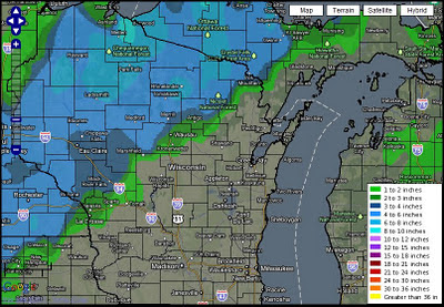
(Snowfall Analysis ending 7am Dec 4, 2011)
We should all be aware that when this storm recurs around Jan 20, 2012 our area could be in the bullseye for the snowfall. Let's hope so! It could make for a snowy Conference Championship game at Lambeau!
(OSNW3 Weather Brief)
(OSNW3 December Observations)
(OSNW3 December 2011 Summary)
 (click on graph for the month summary data - it will open a new tab/window)
----
Lake Winnebago Lake Effect Snow
A very rare event took place the night of Dec 2, 2011. A small band of lake effect snow formed off of Lake Winnebago. I can confirm the Winnebago Lake Effect Snow event, however I have to do it without photos unfortunately. There was about a tenth to two tenths of an inch of snow that fell in North Fond Du Lac along highway 45. It provided a nice coating on cars and flat surfaces. Below is a radar snapshot from the Weather Watch 12 team of WISN12 in Milwaukee, and a radar loop from Intellicast. Click images for larger views.

Unfortunately the North Fond Du Lac observer was unable to submit a report the morning of Dec 2 but there was a report from the southwest portion of the city.
FCDW3 FOND DU LAC FOND DU LAC-2 SW 36 19 0.06 0.3(snow) T
----
Meteorological Autumn
For what seemed like a dry Autumn in 2011 it is actually the 22nd wettest in Oshkosh history. Weather records for Oshkosh date back to 1893. Click image for a larger view.

----
Front Of House
A snowless December landscape
(FOH - Dec 4, 2011)

(Snowfall Analysis ending 7am Dec 4, 2011)

We should all be aware that when this storm recurs around Jan 20, 2012 our area could be in the bullseye for the snowfall. Let's hope so! It could make for a snowy Conference Championship game at Lambeau!
(OSNW3 Weather Brief)
(OSNW3 December Observations)
(OSNW3 December 2011 Summary)
----
Lake Winnebago Lake Effect Snow
A very rare event took place the night of Dec 2, 2011. A small band of lake effect snow formed off of Lake Winnebago. I can confirm the Winnebago Lake Effect Snow event, however I have to do it without photos unfortunately. There was about a tenth to two tenths of an inch of snow that fell in North Fond Du Lac along highway 45. It provided a nice coating on cars and flat surfaces. Below is a radar snapshot from the Weather Watch 12 team of WISN12 in Milwaukee, and a radar loop from Intellicast. Click images for larger views.

Unfortunately the North Fond Du Lac observer was unable to submit a report the morning of Dec 2 but there was a report from the southwest portion of the city.
FCDW3 FOND DU LAC FOND DU LAC-2 SW 36 19 0.06 0.3(snow) T
----
Meteorological Autumn
For what seemed like a dry Autumn in 2011 it is actually the 22nd wettest in Oshkosh history. Weather records for Oshkosh date back to 1893. Click image for a larger view.
----
Front Of House
A snowless December landscape
(FOH - Dec 4, 2011)

Wow I never thought I would hear of Lake Effect Snow off that lake in your area! how interesting! Our landscape is anything but snowy here in Rochester, we got 4.25" of snow. The 1st real snowfall of the season. Pics are on my blog and on facebook. Hopefully you can re join the rest of the Upper Midwest and get some more snowfall before Christmas!
ReplyDeleteHey D! I peeped your photos. Great scene around SE MN. We'll get there soon enough. I guarantee a white Christmas. ;) The LES is totally crazy. This is the first time I've heard or scene it developing off of Lake Winnebago. Awesome stuff!
ReplyDeleteWe are getting an early season snow. Funny, to the north it is raining. Just got to love TN.
ReplyDeleteSuzanne, it is certainly a 'flip-flop' of sorts! As hard as it is to believe, I am enjoying it. I hope TN is treating you well! Do you have any photos of the snow?
ReplyDeleteTN is known for its flip flops.
ReplyDeleteI have one of the hillside across the way which has a dusting still on it. We got about quarter inch dusting...not bad for being about 40 miles from the Alabama state line.
What is really cool, did not have a camera handy, we were down at Mt. Eagle TN, near Chattanooga, and there was still a little snow on he shady side of the Mt. Looks like they received 3-4 in of snow.
ReplyDeleteSuzieE, thanks for the updates. Seems like Old Man Winter is taking the sourthern route thus far.
ReplyDelete