Winds & Waves - Door County, WI
Discussions during the days leading up to Sep 30 revolved around forecasts for central and eastern south shores of Lake Superior being targeted for extreme winds and waves and the idea that I planned to visit Marquette, MI to capture as much of the event as I could. Turns out the time I had available wasn't enough for a trip to the UP. Instead I choose to take a trip to the Door County Peninsula.
(My route to Door County)

My initial thoughts were to adventure along the Peninsula State Park shoreline but when I arrived the park was closed and was to remain closed until further notice. My plan was derailed but the Door County Peninsula never disappoints if one is patient in finding the right spot. I continued north through Sister Bay, Ellison Bay and Gills Rock for a final destination of Kenosha Park, the very top of the Peninsula. This wind event left many roads throughout Door County impassable and many residents and businesses powerless from Carlsville to Fish Creek. A local business woman told me there was a 60mph gust in Fish Creek the night before. It was evident all throughout Door County that a very powerful wind storm had pushed through.
(One of the many downed trees)

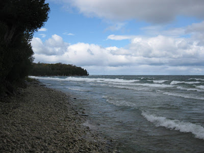
When I reached Kenosha Park I was greeted with the wind and wave scene I was searching for. I quickly climbed down the cliff to the rocky shore and began snapping photos and taking videos.
(Kenosha Park)

(Kenosha Park Beach)
(Kenosha Park)
After an hour at Kenosha Park it was time to head back to Oshkosh, but on the way back I decided to stop in Sister Bay to get a glimpse of the winds and waves in the harbor. It certainly was worth the extra half hour.
(Sister Bay Harbor)

(Sister Bay Harbor)
During the day of Sep 30 the storm was moving out and the windy conditions were beginning to wane. The storm peaked the previous night, Sep 29. Needless to the say the storm was still packing a punch. When this part of the pattern repeats near the end of fall it could certainly be another dandy. Below are a few maps to give an idea of the magnitude of the event.
(500mb Plot)

(Surface Analysis)

(Satellite)

(Radarloop)

More photos and videos can be found by clicking on the links.
(My route to Door County)
My initial thoughts were to adventure along the Peninsula State Park shoreline but when I arrived the park was closed and was to remain closed until further notice. My plan was derailed but the Door County Peninsula never disappoints if one is patient in finding the right spot. I continued north through Sister Bay, Ellison Bay and Gills Rock for a final destination of Kenosha Park, the very top of the Peninsula. This wind event left many roads throughout Door County impassable and many residents and businesses powerless from Carlsville to Fish Creek. A local business woman told me there was a 60mph gust in Fish Creek the night before. It was evident all throughout Door County that a very powerful wind storm had pushed through.
(One of the many downed trees)

When I reached Kenosha Park I was greeted with the wind and wave scene I was searching for. I quickly climbed down the cliff to the rocky shore and began snapping photos and taking videos.
(Kenosha Park)

(Kenosha Park Beach)

(Kenosha Park)
After an hour at Kenosha Park it was time to head back to Oshkosh, but on the way back I decided to stop in Sister Bay to get a glimpse of the winds and waves in the harbor. It certainly was worth the extra half hour.
(Sister Bay Harbor)

(Sister Bay Harbor)
During the day of Sep 30 the storm was moving out and the windy conditions were beginning to wane. The storm peaked the previous night, Sep 29. Needless to the say the storm was still packing a punch. When this part of the pattern repeats near the end of fall it could certainly be another dandy. Below are a few maps to give an idea of the magnitude of the event.
(500mb Plot)

(Surface Analysis)

(Satellite)

(Radarloop)
More photos and videos can be found by clicking on the links.
What a potent storm! Glad you were able to capture some of Mother Nature's wrath! Hopefully this was the 1st in many gale/storm force events for Lakes Superior and Michigan this season :)
ReplyDeleteTim, yes it was fun. I hope so as well, I do love me some winds and waves. I wish I would've seen what was happening in the UP, but perhaps late this the fall or early this winter another opportunity will present itself!
ReplyDelete