Another Dry August
August is nearing it's end and we here in Oshkosh have had yet another below average August in the precipitation department. A recurring theme the past four years. OSNW3 is currently 2.92 inches below the Oshkosh average (1971-2000) precipitation for the month of August, just 29% of average. The forecast for the remainder of August doesn't provide much of a chance of raising that percentage either.
(OSNW3 Weather Brief)
(OSNW3 August Observations)
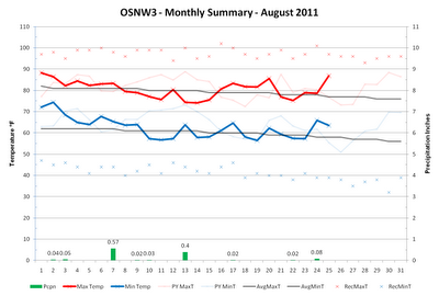
(OSNW3 August 2011 Summary)
----
Precipitation Totals Through Aug 25, 2011
Our surplus of precipitation is taking a hit this August. Down almost three inches since July from 6.17 inches of surplus precipitation to 3.25 inches of surplus precipitation. It's evident in the surroundings, our grass is turning brown and the trees are starting to quickly lose their green. Dry conditions with cool nights will certainly speed the foliage changing process. We could be in store for a vibrant fall color season.
(OSNW3 Precipitation - Monthly)

(OSNW3 Precipitation - Annual)

----
Queen City of the North
We visited Marquette, MI last weekend (Aug 19-21) which just happened to be the weekend that the 'signature' storm of the LRC was returning. Warm southerly winds and thunderstorms in the area on Aug 19, cooler with northwest winds on Aug 20-21. On Aug 19 we hit up Little Presque Isle, Aug 20 we hit up Presque Isle and an adjacent beach, Aug 21 we hit up Presque Isle again and then Dead River Falls. As always a fantastic trip. Love Marquette. More photos can be found here.
(Atop Little Presque Isle)

(Presque Isle)

(Dead River Falls)

----
Front Of House
Things are certainly browning up around here. I have updated the OSNW3 webcam noon images. With my neighbors huge growth in the garden, watching the images in a slideshow is like watching a cheap version of a Planet Earth scene of plant growth. Pretty cool. I also updated FOH images. There is an update over at the OSNW3|LRC blog as well.
(FOH - Aug 25, 2011)

(OSNW3 Weather Brief)
(OSNW3 August Observations)
(OSNW3 August 2011 Summary)
(click on graph for the month summary data - it will open a new tab/window)
----
Precipitation Totals Through Aug 25, 2011
Our surplus of precipitation is taking a hit this August. Down almost three inches since July from 6.17 inches of surplus precipitation to 3.25 inches of surplus precipitation. It's evident in the surroundings, our grass is turning brown and the trees are starting to quickly lose their green. Dry conditions with cool nights will certainly speed the foliage changing process. We could be in store for a vibrant fall color season.
(OSNW3 Precipitation - Monthly)
(OSNW3 Precipitation - Annual)
----
Queen City of the North
We visited Marquette, MI last weekend (Aug 19-21) which just happened to be the weekend that the 'signature' storm of the LRC was returning. Warm southerly winds and thunderstorms in the area on Aug 19, cooler with northwest winds on Aug 20-21. On Aug 19 we hit up Little Presque Isle, Aug 20 we hit up Presque Isle and an adjacent beach, Aug 21 we hit up Presque Isle again and then Dead River Falls. As always a fantastic trip. Love Marquette. More photos can be found here.
(Atop Little Presque Isle)

(Presque Isle)

(Dead River Falls)

----
Front Of House
Things are certainly browning up around here. I have updated the OSNW3 webcam noon images. With my neighbors huge growth in the garden, watching the images in a slideshow is like watching a cheap version of a Planet Earth scene of plant growth. Pretty cool. I also updated FOH images. There is an update over at the OSNW3|LRC blog as well.
(FOH - Aug 25, 2011)

Just saw your tweet. We are dry as well no precip for a full month now. Our warm days seem to be now running in the 90's. Forecast calls for cool down by end of month and early Sept.
ReplyDeleteBeen a wetter than average month here in Duluth, over 5.00" so far. Weird how summer rains hit some spots and miss other areas. I'm sure you'll get a nice drenching soon, Josh..lol
ReplyDeleteBob, I am pretty sure we'll see some rain once the humid air rolls again late this week. I will admit I would rather the warm and humid air stay south of us, as I am looking forward to Autumn.
ReplyDeleteTim, only a matter of time right? :)
OSNW3, Bob, Timothy:
ReplyDeleteOur little part of TN has been DRY, also. Since We departed for OSH, 8-22 rain amounts have been 1.54". Nice thing, lawn mowing duties have been at minumum. My water bill will be BAD due to watering.
SuzieE, seems you part of TN may be getting some good rains now, eh?! Do you have any exciting cloudscapes to share of what once was Lee?
ReplyDeleteNo clouds of interest yet.
ReplyDeleteI was up at 130AM measuring, had 2.55 in since the start of the storm. If I had a good camera, the whole skyline toward the south was cool. At 730AM an additional 1.30 had fallen. I do have cloud pics from our trip to OSH, the early Wed morning storm and the Sunday storm if you are interested.
I am certainly interested in seeing your photos from EAA and your time in Oshkosh!
ReplyDelete