February Thaw On The Horizon
I was quickly taking a snowfall measurement the night of Feb 7 and recall snow creeping into the top of my boots onto my bare feet inside. That got me thinking about the depth of our current snow pack and how it is relatively deep at the moment. Our snow pack has been on the rise since the new year thaw and hovering around a double digit depth since the beginning of February. Maintaining a below freezing maximum temperature all but one day since Jan 1 has helped our snow pack stick around and deepen. The 2010-11 Winter Duration Graph shows this fairly well. We are now in our 55th day of winter according to the definition of a winter season at OSNW3. This tide is changing in the coming week however, as temperatures are forecast to rise above freezing on multiple days. Remember New Years Eve? That portion of the pattern is cycling back around. Keep up on the latest forecast by visiting the Oshkosh Weather Brief link below. The January climate summary can be found here.
(OSNW3 Weather Brief)
(OSNW3 February Observations)
(OSNW3 February 2011 Summary)
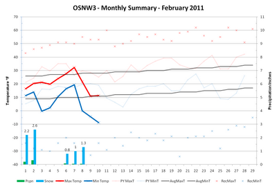
(click on graph for the month summary data - it will open a new tab/window)
----
Weekly Snowfall
Our friend MarkMartin held down the fort in our absence for the Feb 6 observation. He is a dedicated observer. We appreciate his consistent willingness to volunteer his time and help out in a pinch. Sadly the webcam failed to capture him in the act as it defaults a snapshot ever two minutes. Since Jan 28 OSNW3 has recorded 8 days of measurable snow accumulating 9.7 inches. This brings our season total to 37.2 inches.
(Jan 29, 2011 - 1.2")

(Jan 30, 2011 - 0.2")

(Jan 31, 2011 - 0.4")

(Feb 1, 2011 - 2.2")

(Feb 2, 2011 - 2.6")

(Feb 6, 2011 - 0.8")

(Feb 7, 2011 - 1.0")

(Feb 8, 2011 - 1.3")

----
Seasonal Snowfall
The seasonal snowdepth graph located below plainly shows that our current snow pack hasn't been this deep during this time of year for the past 4 years. It's been a great rebound since NYE and when the opportunity has presented itself the snow has been fun to roll around in.
(OSNW3 Seasonal Snowdepth 2006-2011)

(OSNW3 Seasonal Snowfall 2006-2011)

----
Door County Road Trip
Alicia and I spent a little over 24 hours on Feb 5-6 in the great winter confines of the Door Peninsula. Our outdoor adventure took place on Feb 6 at Cave Point County Park. It is always nice to be on the shoreline of a Great Lake.
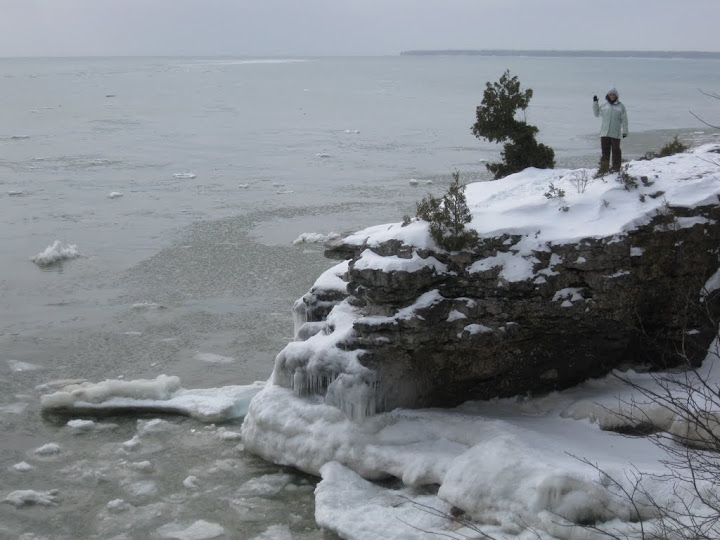
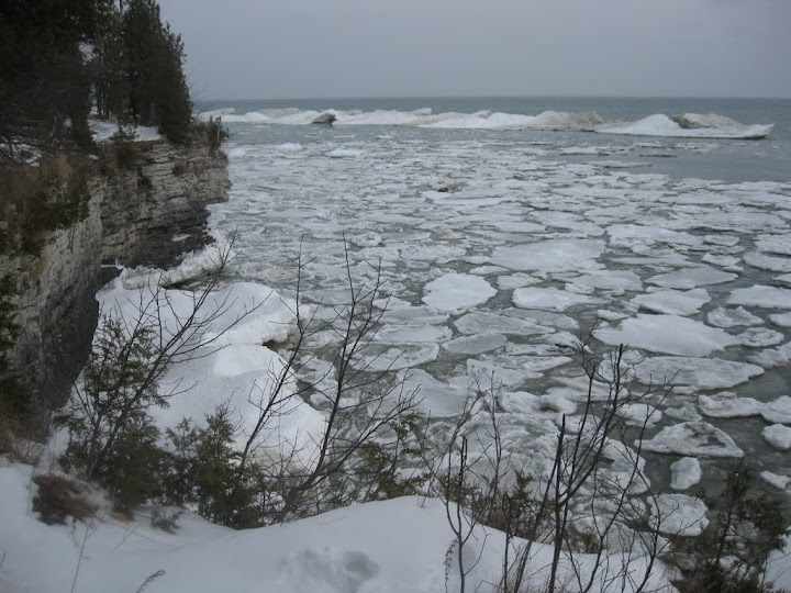
More photos exist here and two videos exist here.
----
A Cold Perspective
In honor of the recently short lived cold blast, I dug up the top ten coldest Oshkosh nights in the last 30 years. The list also includes the maximum temperature of the particular day. It helps me gain a better understanding of each observation period. The coldest reading at OSNW3 this winter season is -10.6 degrees on Jan 21, 2011. More observations located here.
(10 Coldest Nights In Oshkosh - 1981-2011)

----
Front Of House
The front yard has a hefty cover of snow. This will be taking a major hit in the coming week. I am crossing my fingers that the depths of winter can hold back a major thaw. Thinking snow, our friend Jared linked us to some amazing photos of snow monsters in northern Japan. Now that is a lot snow. Packers.
(FOH - Feb 10, 2011)

(OSNW3 Weather Brief)
(OSNW3 February Observations)
(OSNW3 February 2011 Summary)
(click on graph for the month summary data - it will open a new tab/window)
----
Weekly Snowfall
Our friend MarkMartin held down the fort in our absence for the Feb 6 observation. He is a dedicated observer. We appreciate his consistent willingness to volunteer his time and help out in a pinch. Sadly the webcam failed to capture him in the act as it defaults a snapshot ever two minutes. Since Jan 28 OSNW3 has recorded 8 days of measurable snow accumulating 9.7 inches. This brings our season total to 37.2 inches.
(Jan 29, 2011 - 1.2")

(Jan 30, 2011 - 0.2")

(Jan 31, 2011 - 0.4")

(Feb 1, 2011 - 2.2")

(Feb 2, 2011 - 2.6")

(Feb 6, 2011 - 0.8")

(Feb 7, 2011 - 1.0")

(Feb 8, 2011 - 1.3")

----
Seasonal Snowfall
The seasonal snowdepth graph located below plainly shows that our current snow pack hasn't been this deep during this time of year for the past 4 years. It's been a great rebound since NYE and when the opportunity has presented itself the snow has been fun to roll around in.
(OSNW3 Seasonal Snowdepth 2006-2011)

(OSNW3 Seasonal Snowfall 2006-2011)

----
Door County Road Trip
Alicia and I spent a little over 24 hours on Feb 5-6 in the great winter confines of the Door Peninsula. Our outdoor adventure took place on Feb 6 at Cave Point County Park. It is always nice to be on the shoreline of a Great Lake.
More photos exist here and two videos exist here.
----
A Cold Perspective
In honor of the recently short lived cold blast, I dug up the top ten coldest Oshkosh nights in the last 30 years. The list also includes the maximum temperature of the particular day. It helps me gain a better understanding of each observation period. The coldest reading at OSNW3 this winter season is -10.6 degrees on Jan 21, 2011. More observations located here.
(10 Coldest Nights In Oshkosh - 1981-2011)

----
Front Of House
The front yard has a hefty cover of snow. This will be taking a major hit in the coming week. I am crossing my fingers that the depths of winter can hold back a major thaw. Thinking snow, our friend Jared linked us to some amazing photos of snow monsters in northern Japan. Now that is a lot snow. Packers.
(FOH - Feb 10, 2011)

Cool pictures of Cave Point Josh. We love Door County but have yet to go in the winter. I wondered what Cave Point looked like in the winter. Thanks for showing me!
ReplyDeleteSteven, glad to read you had a nice time in CA. A buddy of mine who lives in Berkeley said it has been quite warm and dry the past month. Also the surf has been good too.
ReplyDeleteBorn and raised in GB and my first real trip to DC didn't take place until the turn of the century. Since then it has become an annual thing to do during the off season with my wife. Still afraid of going up there in the summer. What Cave Point looked like two winters ago around the same time. Cave Point two years ago
-31F in Nowata, Oklahoma this morning. No..this is not a mistake, and yes..I said Oklahoma.
ReplyDeleteI think we are ALL ready for a warm up. I just hope with the western troughing that any Gulf surge of moisture/rain doesn't add insult to injury for many with a large snow pack.
More food for thought. Research is ongoing in comparing satellite moisture images with prior LRC cycles in the EPAC. It is insane.
Scott
Scott, indeed it was cold down south. I would assume most of the structures down that way are not manufactured to handle such cold temperatures. I am extremely discouraged by the temperature forecast for late next week into the weekend in the central Upper Peninsula of MI. Hopefully the temps stay around freezing and any precipitation that falls is of frozen ice crystal type. I am intrigued by all in depth investigation comparing past LRC cycles. I often contemplate going back and conducting my own research of past cycles. The plan is thwarted each time as I believe I do not have all the tools and experience necessary to conduct such research. One of these days I will pick a particular winter season and just go for it. What kind of database exists for past LRC cycles?
ReplyDeleteScott, ???? EPAC - Eastern Pacific, Atlantic, Caribbean? Tropical forecasting?
ReplyDeleteFlooding in your future? I hope not. We are climbing into the 40's the next several days. We are clear of any snow on the ground around except in higher elevations. I think we are heading to the door that leads us out of winter 2010-11; I had hoped for so much more than what we got.
ReplyDeleteI welcome the thaw, it's been too cold for too long and were burried under 2 feet of snow up here!
ReplyDeleteBob, I wouldn't think so, but one never knows. It is going to get relatively warm next. It looks like there will be a series of moisture latent systems working into your area in the coming days. Will all of it get wrung out in the Cascades before it gets to you? Our winter is certainly not over, but this time through the next LRC cycle, I will bet, in early April we'll be flirting with late spring, summer conditions.
ReplyDeleteDerek! You are a horticulturist, I know you hate the NW WI winters. ;) Glad to read about your Rochester experience. Very exciting!
Josh - "EPAC - Eastern Pacific, Atlantic, Caribbean? Tropical forecasting?"
ReplyDeleteYes to all. Sent you an email.
We are getting a bit of rain with these systems. We had a good wind event associated with the front this past weekend. There is a good amount of moisture coming in from the SW off Oregon. Rain is always welcomed.
ReplyDeleteMissed the big storm last week by the skin of our teeth :( but temperatures of 70 this week. Time to start preparing for a garden. :)
ReplyDeleteSuzieE, garden! Oh my, I won't be thinking garden until middle May. Enjoy your very warm temperatures!
ReplyDelete