Posts

Showing posts with the label Oshkosh Snowfall

2013-14 First Measurable Snow

Image
We recorded our first measurable snow the morning of Nov 22nd. Based on NWS GreenBay NOWData (81-10), Oshkosh's first measurable snow occurs on Nov 26th. Based on OSNW3 data since 2006 , it occurs on the 324th day of the year, which is Nov 19-20th.

Met Winter (DJF) Stats

Image
Oshkosh residents have endured a fair share of snow this winter. Nearly doubling the long term average snowfall for meteorological winter (Dec, Jan, Feb). Officially, the Waste Water Treatment Plant has recorded 48.7 inches of snow. Stations on the north and south sides of the city have recorded 39.3 and 61.0 inches respectively. At OSNW3, a mile east of the WWTP, we recorded 57.1 inches. These are very respectable amounts. Any amount over 48 inches is in the Oshkosh top ten of all-time for a meteorological winter season. A list view of the final Winnebago County snow amounts can be found here . (Make sure to click the "chart" link - it's a drill down!) The area had the snow , but what about the cold? While February was below average (summary below), both daily maximum and minimum temperatures were above average for the winter. Very close to one degree for the maximum and two degrees for the minimum. OSNW3 February 2013 Daily Observations (click on graph for th...

January 12 Snowfall Recap

Image
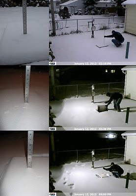
A Winter Storm Watch was in effect for the entire area Jan-12, 2012. It became a significant event because it was our first chance at more than an inch of snow since Nov-9, 2011. The snow began around 7am and lightly came down for the entire day. A moderate push of snow occurred mid-afternoon but did not last for more than a hour. Snowfall rates averaged a little over a quarter inch per hour throughout the 14-15 hour duration of snowfall. Flakes were small, light and wind blown. Here at OSNW3 we measured a storm total of 4.0 inches. (Jan 12, 2012 - 4.0") (Regional Radarloop - Jan 12, 2012) Totals from around Oshkosh range from 4.0 to 4.2 inches. A very consistent snowfall as snowfall often varies a bit from north to south in Oshkosh. The consistency continues throughout Winnebago county and the rest of the area. See image below for state wide totals (click image for more details). Don't be deceived by the purple up by Ironwood, it should really be red to orang...

The Great Lakes Cyclone IV

Image
Our neighbors across the street, the owners of the TAS , were raking their front lawn this past Sunday. I stepped out of my front door and mentioned to them that it is to early for raking as I still had snow in my front yard. I also mentioned that a storm was coming and there will soon be snow covering the ground again. Either way, they are ahead of the spring clean up game and it inspired me later that afternoon to finish trimming a tree and picking up random small pieces of trash that some how float into my yard. It was a well deserved clean up after 95 days of winter. Winter officially ended at OSNW3 on Mar 22. It doesn't look like it at the moment with the fresh coating of snow or feel like it with temps dipping into the low teens at night barely making it above freezing for highs the next day. Adding the fact that we are locked into this pattern for another week or more will make it feel like winter even more. However, a warm up is coming. Plan for the second week of ...

Winter/Spring Metamorphosis

Image
The seasonal transition from winter to spring is upon us. With a minimal base of snow lingering, chances of rain this week, and max temps not forecast to dip below the freezing mark for the next two weeks, visions of Old Man Winter packing up and leaving will become a common site. Officially winter has a very good chance of ending mid next week here at OSNW3 which is quite typical since 2006. However, looming is the 'signature' storm of this years LRC ( Lezak's Recurring Cycle ). Most everyone remembers the storms from Oct 25-28 , Dec 11-12 , and Feb 1-2 and now we look forward to the return mid to late next week. Models will zig zag the track and timing up until the last minute so pin pointing precip type is difficult. Just know that it's coming and it will affect our region in a similar fashion as the three previous times through the cycle. ( OSNW3 Weather Brief ) ( OSNW3 March Observations ) (OSNW3 March 2011 Summary) (click on graph for the month summary dat...

Meteorological Spring Has Arrived!

Image
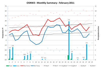
Meteorological winter has come to an end. It has been a season of extraordinary learning accompanied by many, many snow measurements. Since the last blog entry it has snowed seven times and I've taken at least twice as many measurements. Twenty-one inches of snow fell this February at OSNW3 which is more than double the average snowfall for Oshkosh. We maintained almost a ten inch snow depth for the month but not with out a complete melt down over a seven day stretch with temperatures topping the freezing mark to start the second half. The final week knocked the spring fever out of the air reminding all of us winter really wasn't over. March looks to be an active month trending toward the wintry side peaking near the end of the month with the fourth iteration of the Great Lakes Cyclone . Spring will be delayed a few weeks compared to last year with our first real taste not until the second week of April. March Forecast – Based on Lezak’s Recurring Cycle - Jeremy Nelson Wea...

February Thaw On The Horizon

Image
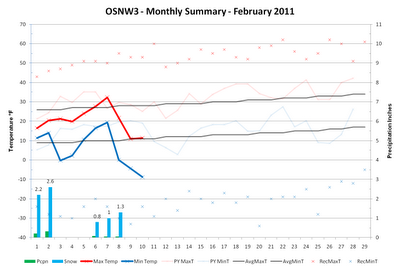
I was quickly taking a snowfall measurement the night of Feb 7 and recall snow creeping into the top of my boots onto my bare feet inside. That got me thinking about the depth of our current snow pack and how it is relatively deep at the moment. Our snow pack has been on the rise since the new year thaw and hovering around a double digit depth since the beginning of February. Maintaining a below freezing maximum temperature all but one day since Jan 1 has helped our snow pack stick around and deepen. The 2010-11 Winter Duration Graph shows this fairly well. We are now in our 55th day of winter according to the definition of a winter season at OSNW3. This tide is changing in the coming week however, as temperatures are forecast to rise above freezing on multiple days. Remember New Years Eve? That portion of the pattern is cycling back around. Keep up on the latest forecast by visiting the Oshkosh Weather Brief link below. The January climate summary can be found here . ( OSNW3 ...

The Month Of The Heart Of Winter

Image
The first two weeks of January have been slightly warmer than what is typical for this time of year, a bit snowy, and mostly cloudy. Only 3 days out of the last 14 have presented the area with cloudless skies but on a bright side only 4 of them have been completely overcast. Otherwise it's been a mixed sky with sun. We've experienced 9 days with at least a Trace of precipitation and 7 days with measurable precipitation. Snowfall totals since the beginning of the month are around average. Real close to what the CPC predicted two weeks ago. As for what the second half of the month will bring, the CPC is showing colder times with good chances of above average precipitation. ( OSNW3 Weather Brief ) ( OSNW3 January Observations ) (OSNW3 January 2011 Summary) (click on graph for the month summary data - it will open a new tab/window) ---- Weekly Snowfall Since the new year meltdown, day after day of at least a Trace of snowfall has kept the non-shoveled paths full of snow. Contin...