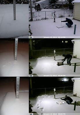
January 12 Snowfall Recap
A Winter Storm Watch was in effect for the entire area Jan-12, 2012. It became a significant event because it was our first chance at more than an inch of snow since Nov-9, 2011. The snow began around 7am and lightly came down for the entire day. A moderate push of snow occurred mid-afternoon but did not last for more than a hour. Snowfall rates averaged a little over a quarter inch per hour throughout the 14-15 hour duration of snowfall. Flakes were small, light and wind blown. Here at OSNW3 we measured a storm total of 4.0 inches.
(Jan 12, 2012 - 4.0")
(Regional Radarloop - Jan 12, 2012)
Totals from around Oshkosh range from 4.0 to 4.2 inches. A very consistent snowfall as snowfall often varies a bit from north to south in Oshkosh. The consistency continues throughout Winnebago county and the rest of the area. See image below for state wide totals (click image for more details). Don't be deceived by the purple up by Ironwood, it should really be red to orange, as Tim lists for us.
4.0 OOHW3,OSHKOSH-5 N
4.0 OSNW3,OSHKOSH-NORTH
4.2 OKHW3,OSHKOSH-WWTP
4.0 OOSW3,OSHKOSH-6 S
(Regional Snowfall Map Ending 7am Jan-13, 2012)
I was able to grab a before and after photo of the Fox River from the Congress Avenue bridge. The walk to and from the bridge was a long awaited journey. I am glad the snow is back.
(Looking Northwest - Oshkosh, WI - Jan 12, 2012)
(Looking Northwest - Oshkosh, WI - Jan 13, 2012)
The front of the house is looking more like winter as well.
(FOH - Jan 13, 2012)


Hey, glad to see snow your way. That same system brought us a dusting. The cold is about two weeks late this year, but I am sure it will change soon as is normal for TN.
ReplyDeleteYes, me too! I think the cold is late everywhere east of the Mississippi River. It will get relatively warm again this winter as the patterns are cycling. This coming week will be 'active' though.
ReplyDeleteIt's white in Oshkosh again. Yay! Looks like a nice little storm for you today.
ReplyDeleteOur total is only 2.1" for the year so far. Amazing
wxwtchr, we picked up 1.1" today. About 3" on the ground. Nothing Earth shattering. However, I will admit, it looks and feels AWESOME!
ReplyDeleteActive weather, yeterday, F0 Tornado in Rutherford Co, TN. Yes, we have snow one day and tornadoes the next! :)
ReplyDeleteSuzanne, seems like the going rate of change lately. I hope all in the paths of such weather heed all the warnings properly.
ReplyDelete