Summer Has Arrived
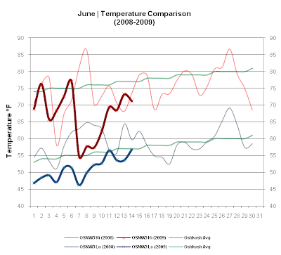
The first two weeks of June in 2009 have been cool. So cool that since 2000 no first two weeks of June have been this cool. Is it an official record? I do not know, but I'd like to find out. As for Summer arriving, it indeed has. Max temperatures are above 70 and as far out as I am willing to believe a forecast, things will stay this way. The cool start is now history. This past week brought some drenching rains early, nearing the 2" by the week end which is keeping us well saturated thus far. (OSNW3 June Observations)
(Temp Comparison 2008 / 2009 | June 1 - 14)
Max Avg: 73.0 / 67.4 / -5.6
Min Avg: 59.1 / 51.1 / -8.0

(June 2009 Precipitation | June 1 - 14)
2009 Monthly Total
Precip.. 2.39"
Oshkosh Average
Precip.. 3.66"
Departure
Precip.. -1.27"

----
A Record Cool Start
Here at OSNW3, the first two weeks of June in 2009 have been the coolest on record. Data recording began at OSNW3 in November of 2006. Comparing the first two weeks of the first two Junes that are now in the books with this June, their mean temperatures are some 6+ degrees higher. Astounding differences in my opinion. For the fun of it, I compared the precipitation data as well. Nothing out of the ordinary for this June, really, but there is quite a difference seen between the maximum precipitation total and the minimum since 2000. Referencing the precipitation graph below it stands out quite noticeably.
(June 1-14 | Mean Temperature)

(June 1-14 | Total Precipitation)

If you are interested in the complete data set used for this summary, please click here.
----
Front Of House
No grass cutting took place this past week, again.
That keeps me at 3.
(FOH - June 14, 2009)

(Temp Comparison 2008 / 2009 | June 1 - 14)
Max Avg: 73.0 / 67.4 / -5.6
Min Avg: 59.1 / 51.1 / -8.0

(June 2009 Precipitation | June 1 - 14)
2009 Monthly Total
Precip.. 2.39"
Oshkosh Average
Precip.. 3.66"
Departure
Precip.. -1.27"

----
A Record Cool Start
Here at OSNW3, the first two weeks of June in 2009 have been the coolest on record. Data recording began at OSNW3 in November of 2006. Comparing the first two weeks of the first two Junes that are now in the books with this June, their mean temperatures are some 6+ degrees higher. Astounding differences in my opinion. For the fun of it, I compared the precipitation data as well. Nothing out of the ordinary for this June, really, but there is quite a difference seen between the maximum precipitation total and the minimum since 2000. Referencing the precipitation graph below it stands out quite noticeably.
(June 1-14 | Mean Temperature)

(June 1-14 | Total Precipitation)

If you are interested in the complete data set used for this summary, please click here.
----
Front Of House
No grass cutting took place this past week, again.
That keeps me at 3.
(FOH - June 14, 2009)

Hey, great blog (:
ReplyDeleteIt was cold in June where I live too. We had snow!!
Keep up the great work, I really enjoy your blogs!
Look at you basking in the cool Wisconsin sun. My word, it has been downright cold for June standards!! Didn't you say before that you wore a coat earlier this month? That is simply amazing.
ReplyDeleteSpeaking of amazing, I'm always shocked when I look at your June precip total for last year. It looks like our July total last year...but we had the remnants of Hurricane Ike (plus another who's name escapes me) to thank for that total. Look at the difference between '06 and '08. Quite a variation!
I've got a graph going for a comparison of our temps this month. I'll shoot it your way at the end of the month.
Thank you Lauren, I appreciate your comment! Spill the beans, where do you live? Snow in June... let me guess WY? ND? NY? Canada?
ReplyDeleteWxWatcher, I've had a coat on for the most part, since June started, but I think you may be referring to my chook (a Yooper term for Winter Hat) ... as I had to wear one two weeks ago during a walk. I updated the graph last night after reading your comment to include the monthly total. If you check out the graph one more time you'll notice that the rest of June last year was practically bone dry after the deluge. I am hyped to see our differences. whOOp!
WxWatcher... I am completely uncertain of which other hurricane you are referring too, but I have two loops that bring hurricane rains to your area. Click for loop.
ReplyDeleteGustav (late Aug, early Sep)
Ike (middle Sep)
Jeez..that's what I get for not double checking my comment. I knew we got a ton of rain from Ike and Gustav, I was assuming it was in July when we had the huge rain total.
ReplyDeleteRead here for the write up about the July rain totals in the St. Louis WFA.
hehe, no sweat man! I wasn't trying to point out a mistake, I hope you didn't read it that way. :)
ReplyDeleteThat link states that majority of the rainfall came during the last week and a half. Amazing how fast things can change depending on Mother Nature's mood.
Wow. Mexico got hammered. 17.19! Fulton had it a healthy does as well.
Oh, no. I didn't take it that way at all! It's a self-critical thing I have :o)
ReplyDeleteWxWatcher, I understand. I am a self critic myself.
ReplyDeleteWe had some decent rain overnight. 0.84" which brings us closer to our monthly average. Since I've been observing we've had the two extremes in my opinion. This year we're heading the middle of the road it would seem.
Oh boy, some "Dawg Days" on the horizon perhaps. Ugh... hopefully not, but we'll see.
ReplyDeleteSunday: Mostly sunny, with a high near 81.
Sunday Night: Partly cloudy, with a low around 65.
Monday: A chance of showers and thunderstorms. Mostly cloudy, with a high near 80.
Monday Night: A chance of showers and thunderstorms. Mostly cloudy, with a low around 66.
Tuesday: A chance of showers and thunderstorms. Mostly cloudy, with a high near 81.
Tuesday Night: Mostly cloudy, with a low around 66.
Wednesday: Mostly sunny, with a high near 83.
We hit 95 today with a dew point temp of 78!
ReplyDelete