Posts

Showing posts with the label Summer

Webcam Timelapse - Through Summer Solstice

#OSNW3 - Webcam 2012 thru Summer Solstice: youtu.be/X4GrqbjlUo0 via @ youtube Evidence of our futile winter. #wiwx #Oshkosh — Josh Herman (@OSNW3) June 29, 2012 The first half of 2012 has been an eye catcher here in Oshkosh. Through the window of my webcam enclosure it becomes evident quite quickly that something is bit abnormal with the weather outside. - Lack of persistent snow cover - Noon temperatures in the 30s in February - Countless days in the 70s in March - Two separate backyard floods days apart There is a lot to see in this timelapse. If anything stands out to you let me know in the comments section of the blog. Enjoy! My neighbors new fence is awesome and will give extra volume to snowfalls this coming winter...

How Was Your Summer?

Image
OSNW3 Meteorological Summer Statistics Precipitation In 2010 OSNW3 ranked second all-time for the wettest meteorological summer in Oshkosh history with 20.41 inches falling during the months of June, July, and August. In 2011 OSNW3 measured 10.36 inches coming in 44th all-time. 0.23 inches below the all-time average of 10.59 inches for the 103 years of data without a missing precipitation observation during the meteorological summer months. This particular data may come across like we had a 'dry' summer, but on 36 days we here at OSNW3 recorded measurable precipitation. Just short of the top ten, coming in at 11th for the most days with measurable precipitation all-time. Providing a some what active three months. More meteorological summer precipitation numbers can be found by clicking the image below. Annual precipitation numbers can be found here . (Oshkosh Meteorological Summer - Precipitation) Temperature Here at OSNW3, 2011 finished 0.9 degrees cooler than 2010,...

Summer Has Arrived

Image
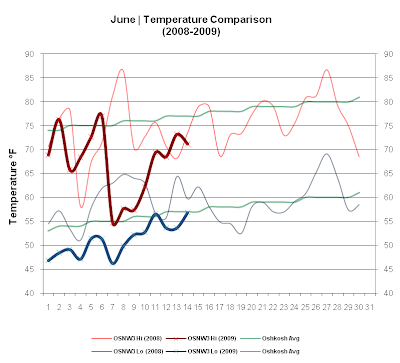
The first two weeks of June in 2009 have been cool. So cool that since 2000 no first two weeks of June have been this cool. Is it an official record? I do not know, but I'd like to find out. As for Summer arriving, it indeed has. Max temperatures are above 70 and as far out as I am willing to believe a forecast, things will stay this way. The cool start is now history. This past week brought some drenching rains early, nearing the 2" by the week end which is keeping us well saturated thus far. ( OSNW3 June Observations ) (Temp Comparison 2008 / 2009 | June 1 - 14) Max Avg: 73.0 / 67.4 / -5.6 Min Avg: 59.1 / 51.1 / -8.0 (June 2009 Precipitation | June 1 - 14) 2009 Monthly Total Precip.. 2.39" Oshkosh Average Precip.. 3.66" Departure Precip.. -1.27" ---- A Record Cool Start Here at OSNW3, the first two weeks of June in 2009 have been the coolest on record. Data recording began at OSNW3 in November of 2006. Comparing the first two weeks of the first two...