Posts

Still Lacking True Winter Conditions

Image
In the last blog entry I discussed the fact that winter may finally be making an appearance in 2011-12. All we needed was one more day of ' winter season duration ' criteria to have fully transitioned, but alas that did not happen. The maximum temperature recorded on Jan-23 for the previous 24 hours was above freezing and in a 'non winter fashion' precipitation fell in the form of liquid. The good news is we should expect two notable storm systems to make their way towards the region during the first half of February. The question is, will the precipitation make into WI and will it be rain or snow? For more information on the storm systems please see the OSNW3|LRC blog entry " Weather Event Forecasting - First Half Of February ". ( OSNW3 Weather Brief ) ( OSNW3 January Observations ) (OSNW3 January 2012 Summary) (click on graph for the month summary data - it will open a new tab/window) ---- Weekly Snowfall Since Jan-22 we've recorded 4 day...
Snowiest Stretch Of The Winter. Wait, Is It Winter Yet?

Image
Winter is showing signs of actually presenting itself in 2011-2012. According to the OSNW3 Winter Season Duration formula, if the maximum temperature for Jan-22 stays below 32 degrees OSNW3 will have finally made the transition into winter. Regardless of the outcome this is the latest beginning to winter since the 2006-07 season . A short lived Arctic air outbreak occurred Jan 19-21 giving the region a taste of winter. Here at OSNW3 our lowest recorded temperature for the three day span, -5.6 degrees, took place during the early morning hours of Jan-20. Looking ahead, using the OSNW3 forecast temperature trend based on the Lezak's Recurring Cycle theory , days will become seasonal with a good amount of them reaching the freezing mark or greater through the first half of February. The Climate Prediction Center (CPC) agrees as well for the next 14 days. I added snowfall forecast maps to the OSNW3 Weather Brief . Check them out. ( OSNW3 Weather Brief ) ( OSNW3 January Obse...

January 12 Snowfall Recap

Image
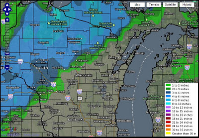
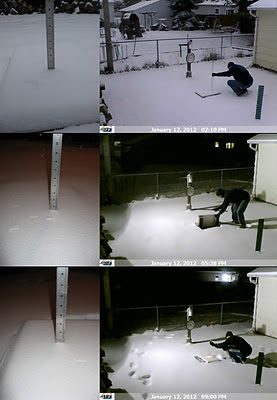
A Winter Storm Watch was in effect for the entire area Jan-12, 2012. It became a significant event because it was our first chance at more than an inch of snow since Nov-9, 2011. The snow began around 7am and lightly came down for the entire day. A moderate push of snow occurred mid-afternoon but did not last for more than a hour. Snowfall rates averaged a little over a quarter inch per hour throughout the 14-15 hour duration of snowfall. Flakes were small, light and wind blown. Here at OSNW3 we measured a storm total of 4.0 inches. (Jan 12, 2012 - 4.0") (Regional Radarloop - Jan 12, 2012) Totals from around Oshkosh range from 4.0 to 4.2 inches. A very consistent snowfall as snowfall often varies a bit from north to south in Oshkosh. The consistency continues throughout Winnebago county and the rest of the area. See image below for state wide totals (click image for more details). Don't be deceived by the purple up by Ironwood, it should really be red to orang...

2011 Weather Summary And A Winter Forecast Performance Review

Image
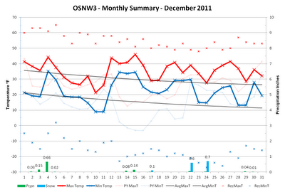
The final two weeks of December had the potential to create some winter weather in our area. Unfortunately we missed out on both opportunities as the systems slid south and east of Oshkosh. While the new year brought a needed taste of winter, the first half of January will trend back towards the lack luster winter weather we saw most of December . The forecast trend is based on Lezak's Recurring Cycle theory and can be found on the OSNW3 LRC blog . A performance review of the LRC based Oshkosh winter predictions I made back in November for the 'first cycle' are located farther down in this entry. The climatology summary for Decemeber is below and the summary for January can be found here . ( OSNW3 Weather Brief ) ( OSNW3 December Observations ) (OSNW3 December 2011 Summary) (click on graph for the month summary data - it will open a new tab/window) ---- Is It Winter Yet? Nope, not by the standards we follow here at OSNW3. The definition of a 'Winter Seaso...

One Measurable Snowfall in the First 18 Days of December

Image
The main weather headline around these parts is the lack of snow. One measurable snowfall in the first 18 days. It is something we haven't witnessed at OSNW3 since we began recording climate data back in November 2006. However, when it comes to averages, it is expected to trend the opposite way after an all-time record setting monthly snowfall in 2008. For snow enthusiasts there is light at the end of the tunnel as snow chances do exist in the final two weeks of the month. For a basic overview of the chances of snow remaining this month visit the OSNW3 LRC analysis blog or get modelitis by visiting the OSNW3 Weather Breif below. ( OSNW3 Weather Brief ) ( OSNW3 December Observations ) (OSNW3 December 2011 Summary) (click on graph for the month summary data - it will open a new tab/window) ---- December Snows With one tenth of snow measured so far this month it is easy to imagine where this month ranks all-time in snowfall. There are seven Decembers that recorded no...

A Near Miss, Lake Effect Snow, And A Look Back At Meteorological Autumn

Image
What could have been. The annual first week of December storm was in full effect for all of WI, but the case for the eastern portions of the state in 2011 was rain with temps in the 40s. Year after year a storm works it's way into the western Great Lakes the first week of December. Most notable in recent history is Dec 2, 2007. Clicking the links below will open the daily climate for December for that particular year. A radar loop is obtainable by clicking the linked daily weather description. 200612 , 200712 , 200812 , 200912 , 201012 . (Snowfall Analysis ending 7am Dec 4, 2011) We should all be aware that when this storm recurs around Jan 20, 2012 our area could be in the bullseye for the snowfall. Let's hope so! It could make for a snowy Conference Championship game at Lambeau! ( OSNW3 Weather Brief ) ( OSNW3 December Observations ) (OSNW3 December 2011 Summary) (click on graph for the month summary data - it will open a new tab/window) ---- Lake Winnebago...

2011-12 Oshkosh Winter Forecast Based On The LRC

Image
I first heard about Lezak's Recurring Cycle theory in early October of 2010 from WISN12's Jeremy Nelson. My initial thoughts were that it was too good to be true. Then it happened, I was convinced after one in-depth analysis that it indeed existed. I will admit it didn't take long for me to buy in and afterwards I wondered why I hadn't heard about it before. A little over a year later and an extreme amount of hours dedicated to research and analysis, following the theory has grown into a passion. To this day I endorse the theory to my fullest capacity. Caught up in all the hype and excitement of learning more about the LRC last winter I attempted a backyard snowfall forecast. Little did I realize that this endeavor would be the proverbial tip of the iceberg. Following the LRC for the past year has led me down a path of constant learning about the upper atmosphere and how it affects the weather on the surface. The benefits of following the theory and thus knowin...