Parade of Storms
I got the idea for the title from Dewdrop, but I think the same idea was being used pretty much everywhere. Regardless. Simply put, that's what it's been. I suppose, since the overall pattern has changed, I would consider the parade over. The parade started back on Dec 17, ushering in system after system each producing moderate amounts of snowfall. However, this last system brought with it some very mild air and rain. OSNW3 lost several inches of snow pack with this last system. The max snowdepth during the parade hit 14" twice, back on Dec 21 and again on Dec 26. At observation time on Dec 28 the snowdepth was 7". This parade has helped many towns in the area break their all-time record snowfall for the month of December. I am confident Oshkosh's record will officially fall once the month is all said and done as well.
(OSNW3 December Observations)
(Parade Photos)
Parade Totals (Dec 17-28)
Liquid - 2.00"
Snowfall - 17.7"
(Temp Comparison 2007 / 2008 | Dec 1 - 28)
Max temp: 28.3 / 25.7 / -2.6
Min temp: 15.4 / 7.4 / -8.0

(December 2008 Precipitation)
2008 Monthly Total
Precip 3.15"
Snow 31.9"
Oshkosh Average
Precip 1.55"
Snow 10.9"
Departure
Precip +1.60"
Snow +21.0"

----
OSNW3 December Snowfall Comparison
The NWS Milwaukee/Sullivan opened their "Top News of the Day" article, Winter 2008 vs Winter 2007, with what maybe the "million dollar question" down there. "Will this winter be just like last winter?". As soon as I saw the graphs that represented the data I naturally had to create this same sort of comparison for OSNW3.
(OSNW3 December Snowfall Comparison)

----
Oshkosh December Snowfall Totals
With all the record breaking December snowfall I thought I'd create a Google Earth tour to display each observer station location along with it's December snowfall total. The image below is a screen shot of the interactive Google Earth file. Data provided by National Weather Service and CoCoRaHS Cooperative Observer Program volunteers. Click here to view in Google Earth. (Data is current as of 9am, Dec 28 and will be updated at the end of the month)

OKHW3
OSHKOSH-WWTP
Lat: 44.033300
Lon: -88.555600
27.5"
WI-WN-1
Oshkosh 1.2 SW
Lat: 44.007281
Lon: -88.572536
19.9" (missing data)
OOSW3/WI-WN-2
OSHKOSH-6 S/Oshkosh 5.6 S
Lat: 43.9375
Lon: -88.5425
35.6"
OSNW3/WI-WN-4 (me)
OSHKOSH-NORTH/Oshkosh 1.3 NNE
Lat: 44.035
Lon: -88.5435
31.9"
WI-WN-5
Oshkosh 5.2 N
Lat: 44.093515
Lon: -88.553089
34.0"
WI-WN-6
Oshkosh 4.5 SSE
Lat: 43.95604
Lon: -88.524916
No Reports
----
Snowfall Dec 23
A quick moving Low was forecast to drop around 6". The snow started falling around 3am and by 7am it was pretty much past us. The snow tracked further southeast quite rapidly. (radar/daily movie)
(1.3" measured @ 6:49am on Dec 23 - Total 1.3")

From that point after the snow basically stopped, but not after accumulating another 0.2". 1.5" total from the Low.
----
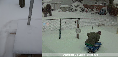
Snowfall Dec 24
Another quick moving Low swept on through for the second consecutive day. This one brought some warmer air with it. Temps hovered around 30°. The snow came down heavy at times. (radar/video)
(0.8" measured @ 8:55am on Dec 24 - Total 0.8")

(0.4" measured @ 10:32am on Dec 24 - Total 1.2")

(0.5" measured @ 1:39pm on Dec 24 - Total 1.7")

----
Snowfall Dec 25-26
The Christmas day snowfall came late in the day, but it did come. Snowed heavy from 10pm to 11pm, then subsided a bit and picked up again in the early morning hours of Dec 26. (radar/video/daily movie)
(1.1" measured @ 11:05pm on Dec 25 - Total 1.1")

(0.7" measured @ 2:55am on Dec 26 - Total 1.8")

(0.1" measured @ 7:06am on Dec 26 - Total 1.9")

----
Snowfall Dec 28
It rained most of the day on Dec 27, but then on the backside of the Low, as one would expect, the cold air moved in, and as it did it layed a fresh coat of snow over the ugly rain soaked snowpack. (radar/daily movie)
(0.4" measured @ 1:25am on Dec 28 - Total 0.4")

(0.6" measured @ 4:26am on Dec 28 - Total 1.0")

One more measurement came at observation time which resulted in another 0.1" bringing the total to 1.1"
----
Front Of House
(FOH - Dec 28, 2008)

(OSNW3 December Observations)
(Parade Photos)
Parade Totals (Dec 17-28)
Liquid - 2.00"
Snowfall - 17.7"
(Temp Comparison 2007 / 2008 | Dec 1 - 28)
Max temp: 28.3 / 25.7 / -2.6
Min temp: 15.4 / 7.4 / -8.0

(December 2008 Precipitation)
2008 Monthly Total
Precip 3.15"
Snow 31.9"
Oshkosh Average
Precip 1.55"
Snow 10.9"
Departure
Precip +1.60"
Snow +21.0"

----
OSNW3 December Snowfall Comparison
The NWS Milwaukee/Sullivan opened their "Top News of the Day" article, Winter 2008 vs Winter 2007, with what maybe the "million dollar question" down there. "Will this winter be just like last winter?". As soon as I saw the graphs that represented the data I naturally had to create this same sort of comparison for OSNW3.
(OSNW3 December Snowfall Comparison)

----
Oshkosh December Snowfall Totals
With all the record breaking December snowfall I thought I'd create a Google Earth tour to display each observer station location along with it's December snowfall total. The image below is a screen shot of the interactive Google Earth file. Data provided by National Weather Service and CoCoRaHS Cooperative Observer Program volunteers. Click here to view in Google Earth. (Data is current as of 9am, Dec 28 and will be updated at the end of the month)

OKHW3
OSHKOSH-WWTP
Lat: 44.033300
Lon: -88.555600
27.5"
WI-WN-1
Oshkosh 1.2 SW
Lat: 44.007281
Lon: -88.572536
19.9" (missing data)
OOSW3/WI-WN-2
OSHKOSH-6 S/Oshkosh 5.6 S
Lat: 43.9375
Lon: -88.5425
35.6"
OSNW3/WI-WN-4 (me)
OSHKOSH-NORTH/Oshkosh 1.3 NNE
Lat: 44.035
Lon: -88.5435
31.9"
WI-WN-5
Oshkosh 5.2 N
Lat: 44.093515
Lon: -88.553089
34.0"
WI-WN-6
Oshkosh 4.5 SSE
Lat: 43.95604
Lon: -88.524916
No Reports
----
Snowfall Dec 23
A quick moving Low was forecast to drop around 6". The snow started falling around 3am and by 7am it was pretty much past us. The snow tracked further southeast quite rapidly. (radar/daily movie)
(1.3" measured @ 6:49am on Dec 23 - Total 1.3")

From that point after the snow basically stopped, but not after accumulating another 0.2". 1.5" total from the Low.
----
Snowfall Dec 24
Another quick moving Low swept on through for the second consecutive day. This one brought some warmer air with it. Temps hovered around 30°. The snow came down heavy at times. (radar/video)
(0.8" measured @ 8:55am on Dec 24 - Total 0.8")

(0.4" measured @ 10:32am on Dec 24 - Total 1.2")

(0.5" measured @ 1:39pm on Dec 24 - Total 1.7")

----
Snowfall Dec 25-26
The Christmas day snowfall came late in the day, but it did come. Snowed heavy from 10pm to 11pm, then subsided a bit and picked up again in the early morning hours of Dec 26. (radar/video/daily movie)
(1.1" measured @ 11:05pm on Dec 25 - Total 1.1")

(0.7" measured @ 2:55am on Dec 26 - Total 1.8")

(0.1" measured @ 7:06am on Dec 26 - Total 1.9")

----
Snowfall Dec 28
It rained most of the day on Dec 27, but then on the backside of the Low, as one would expect, the cold air moved in, and as it did it layed a fresh coat of snow over the ugly rain soaked snowpack. (radar/daily movie)
(0.4" measured @ 1:25am on Dec 28 - Total 0.4")

(0.6" measured @ 4:26am on Dec 28 - Total 1.0")

One more measurement came at observation time which resulted in another 0.1" bringing the total to 1.1"
----
Front Of House
(FOH - Dec 28, 2008)

Comments
Post a Comment