Posts

Autumn Has Taken Hold

Image
The cool and crisp feeling of Autumn is finally being felt here at OSNW3. It took a while. We have yet to dip below the freezing mark, however. Fairly soon though we will be adding the 2011 date to the Winter History page. ( **First Freeze took place on Oct-28 ) The later it comes, the better in my opinion. Only because recent climate trends show more snow falls in winter when the first cold blast takes place a couple weeks later than average. The average first freeze in Oshkosh is Oct 12 (1981-2010). This year has more climatological posibility since it is another La Nina year. A comparison for Oshkosh winters during La Nina is below. "For the second winter in a row, La NiƱa will influence weather patterns across the country, but as usual, it’s not the only climate factor at play. The ‘wild card’ is the lesser-known and less predictable Arctic Oscillation that could produce dramatic short-term swings in temperatures this winter." Read more here . With that said...
Serotonin Overload?

Image
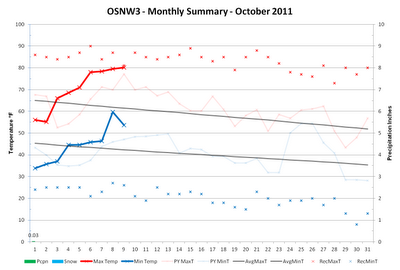
Perhaps. I've got a few cognitive symptoms: agitation (seasonal allergies), hypomania (feels like I am on the 'summer' schedule yet), mental confusion (it's autumn, right?), hallucinations (thought that was a cloud, nope, just contrails). But seriously, we haven't had a cloudy day in quite some time. As a matter of fact the first 216 hours or so of October sky observation have been mainly clear. No quantitative numbers for this statement, just my gut feel. Some numbers that are real however are the ones that describe our lack of precipitation. Only three hundredths of an inch have fallen in October and we are on pace once again to crack the top five longest dry spells at OSNW3 . With the new LRC forming we are forced to follow the computer models for a long range query. The CPC predicts a continuation of above average temperature and below average precipitation. Similar to last year at this time. In the short term however, expect a cool down with chances o...

Winds & Waves - Door County, WI

Image
Discussions during the days leading up to Sep 30 revolved around forecasts for central and eastern south shores of Lake Superior being targeted for extreme winds and waves and the idea that I planned to visit Marquette, MI to capture as much of the event as I could. Turns out the time I had available wasn't enough for a trip to the UP. Instead I choose to take a trip to the Door County Peninsula. (My route to Door County) My initial thoughts were to adventure along the Peninsula State Park shoreline but when I arrived the park was closed and was to remain closed until further notice. My plan was derailed but the Door County Peninsula never disappoints if one is patient in finding the right spot. I continued north through Sister Bay, Ellison Bay and Gills Rock for a final destination of Kenosha Park, the very top of the Peninsula. This wind event left many roads throughout Door County impassable and many residents and businesses powerless from Carlsville to F...

Near Stationary Cut-off Low

Image
I took the opportunity to get out in the elements with mother nature as the area faced it's first real taste of a fall storm system. The nearly stationary low blew consistent northeasterly winds the morning of Sep 26. Gusts close to 30 mph stirred Lake Winnebago initiating a moderate wave event on it's western shores. Some Photos . (Sep 26, 2011) Some Videos . 4 new ones. (Sep 26, 2001) The precipitation from this low pressure thus far has tallied 1.23", dropping measurable precipitation on six of seven days. The NWS GRB labeled it as 'pesky', I guess after seven days it could become a bit pesky. Overall though, the weather hasn't been all that nasty. Sep 26 was really the only harsh day. To view the radar loop of the storm entering into the US and then deciding to cut off, click here . (20MB) Once it turned from cloudy, raining, and windy to sunny and calm on Sep 26, I captured this satellite image. Impressive.

The End Of A Dry Spell & New 30 Year Averages

Image
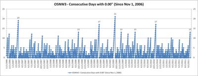
The morning of Sep-19, after 13 consecutive days, we finally recorded measurable precipitation. Most will think that 13 days without measurable precipitation is just the tip of the iceberg, but here in the western portion of the Great Lakes basin we seldom deal with such longevity. Since the genesis of OSNW3, back on Nov 1, 2006, we've recorded just 8 streaks of 13 or more days without measurable precipitation, just 7% of the time. For more information see graph and list below. (day of the streak end is listed) 4 streaks of 13 days Sep-18, 2011 Apr-2, 2010 Nov-18, 2009 Sep-29, 2008 2 streaks of 17 days Oct-20, 2010 Apr-18, 2009 1 streak of 19 days Feb-23, 2007 1 streak of 21 days Sep-20, 2009 These types of streaks do not always lead to drought situations, but with the recent lack of precipitation in the past two months some of Wisconsin is now in a slight drought situation. The recent rain may have helped as most around the state recorded up to a half an inch or...

How Was Your Summer?

Image
OSNW3 Meteorological Summer Statistics Precipitation In 2010 OSNW3 ranked second all-time for the wettest meteorological summer in Oshkosh history with 20.41 inches falling during the months of June, July, and August. In 2011 OSNW3 measured 10.36 inches coming in 44th all-time. 0.23 inches below the all-time average of 10.59 inches for the 103 years of data without a missing precipitation observation during the meteorological summer months. This particular data may come across like we had a 'dry' summer, but on 36 days we here at OSNW3 recorded measurable precipitation. Just short of the top ten, coming in at 11th for the most days with measurable precipitation all-time. Providing a some what active three months. More meteorological summer precipitation numbers can be found by clicking the image below. Annual precipitation numbers can be found here . (Oshkosh Meteorological Summer - Precipitation) Temperature Here at OSNW3, 2011 finished 0.9 degrees cooler than 2010,...

Another Dry August

Image
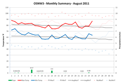
August is nearing it's end and we here in Oshkosh have had yet another below average August in the precipitation department. A recurring theme the past four years. OSNW3 is currently 2.92 inches below the Oshkosh average (1971-2000) precipitation for the month of August, just 29% of average. The forecast for the remainder of August doesn't provide much of a chance of raising that percentage either. ( OSNW3 Weather Brief ) ( OSNW3 August Observations ) (OSNW3 August 2011 Summary) (click on graph for the month summary data - it will open a new tab/window) ---- Precipitation Totals Through Aug 25, 2011 Our surplus of precipitation is taking a hit this August. Down almost three inches since July from 6.17 inches of surplus precipitation to 3.25 inches of surplus precipitation. It's evident in the surroundings, our grass is turning brown and the trees are starting to quickly lose their green. Dry conditions with cool nights will certainly speed the foliage changin...