Posts

Near Stationary Cut-off Low

Image
I took the opportunity to get out in the elements with mother nature as the area faced it's first real taste of a fall storm system. The nearly stationary low blew consistent northeasterly winds the morning of Sep 26. Gusts close to 30 mph stirred Lake Winnebago initiating a moderate wave event on it's western shores. Some Photos . (Sep 26, 2011) Some Videos . 4 new ones. (Sep 26, 2001) The precipitation from this low pressure thus far has tallied 1.23", dropping measurable precipitation on six of seven days. The NWS GRB labeled it as 'pesky', I guess after seven days it could become a bit pesky. Overall though, the weather hasn't been all that nasty. Sep 26 was really the only harsh day. To view the radar loop of the storm entering into the US and then deciding to cut off, click here . (20MB) Once it turned from cloudy, raining, and windy to sunny and calm on Sep 26, I captured this satellite image. Impressive.
The End Of A Dry Spell & New 30 Year Averages

Image
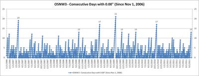
The morning of Sep-19, after 13 consecutive days, we finally recorded measurable precipitation. Most will think that 13 days without measurable precipitation is just the tip of the iceberg, but here in the western portion of the Great Lakes basin we seldom deal with such longevity. Since the genesis of OSNW3, back on Nov 1, 2006, we've recorded just 8 streaks of 13 or more days without measurable precipitation, just 7% of the time. For more information see graph and list below. (day of the streak end is listed) 4 streaks of 13 days Sep-18, 2011 Apr-2, 2010 Nov-18, 2009 Sep-29, 2008 2 streaks of 17 days Oct-20, 2010 Apr-18, 2009 1 streak of 19 days Feb-23, 2007 1 streak of 21 days Sep-20, 2009 These types of streaks do not always lead to drought situations, but with the recent lack of precipitation in the past two months some of Wisconsin is now in a slight drought situation. The recent rain may have helped as most around the state recorded up to a half an inch or...

How Was Your Summer?

Image
OSNW3 Meteorological Summer Statistics Precipitation In 2010 OSNW3 ranked second all-time for the wettest meteorological summer in Oshkosh history with 20.41 inches falling during the months of June, July, and August. In 2011 OSNW3 measured 10.36 inches coming in 44th all-time. 0.23 inches below the all-time average of 10.59 inches for the 103 years of data without a missing precipitation observation during the meteorological summer months. This particular data may come across like we had a 'dry' summer, but on 36 days we here at OSNW3 recorded measurable precipitation. Just short of the top ten, coming in at 11th for the most days with measurable precipitation all-time. Providing a some what active three months. More meteorological summer precipitation numbers can be found by clicking the image below. Annual precipitation numbers can be found here . (Oshkosh Meteorological Summer - Precipitation) Temperature Here at OSNW3, 2011 finished 0.9 degrees cooler than 2010,...

Another Dry August

Image
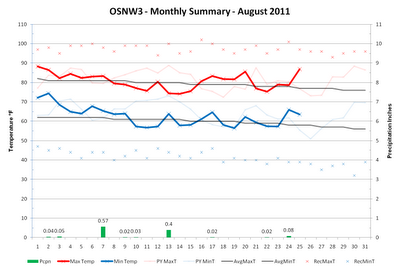
August is nearing it's end and we here in Oshkosh have had yet another below average August in the precipitation department. A recurring theme the past four years. OSNW3 is currently 2.92 inches below the Oshkosh average (1971-2000) precipitation for the month of August, just 29% of average. The forecast for the remainder of August doesn't provide much of a chance of raising that percentage either. ( OSNW3 Weather Brief ) ( OSNW3 August Observations ) (OSNW3 August 2011 Summary) (click on graph for the month summary data - it will open a new tab/window) ---- Precipitation Totals Through Aug 25, 2011 Our surplus of precipitation is taking a hit this August. Down almost three inches since July from 6.17 inches of surplus precipitation to 3.25 inches of surplus precipitation. It's evident in the surroundings, our grass is turning brown and the trees are starting to quickly lose their green. Dry conditions with cool nights will certainly speed the foliage changin...

The Truth of a Heat Wave

Image
It is insane when a temperature of 90 degrees and a dew point of 70 degress brings on a feeling of relief. In Wisconsin this feeling only takes place during an extended heat wave in the middle of summer. That is exactly where we are at. We've been doing our best to keep hydrated and keep the sunscreen applied while outdoors. As for being inside the house we feel very fortunate to have central air to keep things comfortable. Looking ahead there might be a 24 hour period early next week that provides some relief from the heat, but the heat will return and stay with us for another extended period of time. Anyone following the LRC theory (Lezak's Recurring Cycle) knew the recent warmth was coming with great potential to provide extreme summer weather. This part of the pattern has been documented thoroughly via LRC Weather , WeatherWatch12 , and even here at OSNW3 . This coming week is the pattern feature that brought us our first heatwave of the summer back in early June. Th...

Summer is in Full Swing

Image
Our recent pattern has included this years 'signature' storm, the infamous ' Great Lakes Cyclone ', and it's passing. With the jet stream weakening and lifting north the potency of this feature in our area has faded. For warm weather enthusiasts it is a good thing as the cool air that followed each instance this winter and early spring will not reoccur. Instead temperatures should hold around average for this time of year. As the patterns continue to cycle however, I have a sneaky feeling that the setup for what was our first heat wave in early June will show up again near the end of July giving us a chance at a string of extremely hot days. We'll see. For a detailed look back at June click here . ( OSNW3 Weather Brief ) ( OSNW3 July Observations ) (OSNW3 July 2011 Summary) (click on graph for the month summary data - it will open a new tab/window) ---- Precipitation Totals Through June As we move beyond the half way point of 2011 here at OSNW3 we h...

Schools Out For Summer!

Image
Looking at the OSNW3 monthly summary graphs it is evident we've had our ups and downs this year. The pattern has kept cycling, continuing the trend , just as it should. Thus far in June we've had seven days above 80 degrees, but yet remain a little more than a degree below average. We are entering the wetter pattern of this years LRC and we should expect increased chances of precipitation for the next two weeks. The CPC agrees with this idea as well. Keep up to date with the latest forecast by visiting the OSNW3 Weather Brief linked below. For a May summary click here . ( OSNW3 Weather Brief ) ( OSNW3 June Observations ) (OSNW3 June 2011 Summary) (click on graph for the month summary data - it will open a new tab/window) ---- Cloud Appreciation The Cloud Appreciation Society was introduced to me a few years back and it's not often I get to shoot clouds that are unique and worthy of sharing. However, as severe weather rolled just south of Oshkosh we were given...