Posts

Showing posts with the label Waves

First Wind & Waves of 2013
Image
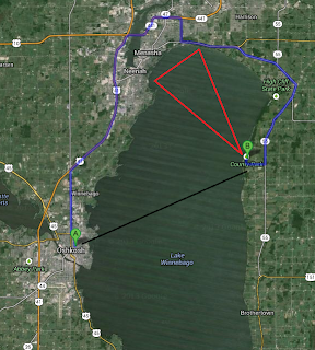
On Saturday October 26th my daughter and I ventured to Calumet County Park . County Park is located almost directly across Lake Winnebago from Oshkosh. About 12 miles as the crow flies and 35 miles by northern road access. Upon arrival, traveling down the Niagara Escarpment , we were witness to an excited Lake Winnebago. Forecast from the NWS Green Bay foretold winds of 15-20 knots and waves of 3-4 feet. This forecast would verify. The sights and sounds were just what we were looking for. Colorful trees whipping wildly with the constant roar of the wind and crashing waves. And of course the playground set. We also witnessed a smoke plume off in the distance towards the northwest depicted in the map above by an approximate red triangle and in the image below by a red circle. It appeared something was burning in East central Calumet County at 2:30 this afternoon, the smoke plume was visible from Neenah. — Clint Harness (@snowfall4) October 26, 2013 Below is a short vid...

Winds & Waves - Door County, WI

Image
Discussions during the days leading up to Sep 30 revolved around forecasts for central and eastern south shores of Lake Superior being targeted for extreme winds and waves and the idea that I planned to visit Marquette, MI to capture as much of the event as I could. Turns out the time I had available wasn't enough for a trip to the UP. Instead I choose to take a trip to the Door County Peninsula. (My route to Door County) My initial thoughts were to adventure along the Peninsula State Park shoreline but when I arrived the park was closed and was to remain closed until further notice. My plan was derailed but the Door County Peninsula never disappoints if one is patient in finding the right spot. I continued north through Sister Bay, Ellison Bay and Gills Rock for a final destination of Kenosha Park, the very top of the Peninsula. This wind event left many roads throughout Door County impassable and many residents and businesses powerless from Carlsville to F...

Near Stationary Cut-off Low

Image
I took the opportunity to get out in the elements with mother nature as the area faced it's first real taste of a fall storm system. The nearly stationary low blew consistent northeasterly winds the morning of Sep 26. Gusts close to 30 mph stirred Lake Winnebago initiating a moderate wave event on it's western shores. Some Photos . (Sep 26, 2011) Some Videos . 4 new ones. (Sep 26, 2001) The precipitation from this low pressure thus far has tallied 1.23", dropping measurable precipitation on six of seven days. The NWS GRB labeled it as 'pesky', I guess after seven days it could become a bit pesky. Overall though, the weather hasn't been all that nasty. Sep 26 was really the only harsh day. To view the radar loop of the storm entering into the US and then deciding to cut off, click here . (20MB) Once it turned from cloudy, raining, and windy to sunny and calm on Sep 26, I captured this satellite image. Impressive.

Great Lakes Cyclone V & A Spring Temperature Comparison

Image
The fifth iteration of the 'signature' storm in this years LRC introduced Oshkosh to it's first bout with summer time heat and humidity. That summer feeling lasted a day. Nothing new though as this is how it has been since November. The cycling pattern teasing folks with a glimmer of warmer times ahead. We are now so far into spring that it is just a matter of time until a smaller temperature contrast between the north pole and the equator creates a weaker jet and summer takes hold in our region. With this thought in mind it is worth mentioning that following the LRC one knows that our region should expect a potent warm-up near the end of the month. This thinking is still on track and if one would enjoy following this part of the 2010-11 LRC through its fruition please visit the WeatherWatch12 blog as Jeremy Nelson will provide many opportunities for learning and opinion sharing. ( OSNW3 Weather Brief ) ( OSNW3 May Observations ) (OSNW3 May 2011 Summary) (clic...