Posts

Showing posts with the label US Radar

Oshkosh's Third "10-Year" Storm In Four Years
Image
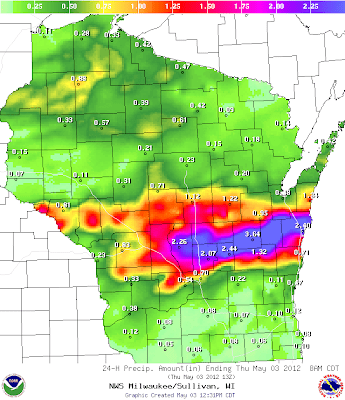
Early morning and into the afternoon on May 3 Oshkosh endured some hefty rainfall amounts. Thunderstorms trained over the city which kept the populous enthralled to sights of bright lightning strikes and sounds of deep thunder roars and pounding rain. (Winnebago County Precipitation Totals) 1.34 MNSW3 MENASHA-JEFFERSON 2.08 NAHW3 NEENAH-EAST 1.55 WNCW3 WINNECONNE-5NW-LK 3.56 OMSW3 OMRO-SOUTHEAST 3.26 OMWW3 OMRO-2 3.10 OOHW3 OSHKOSH-5 4.12 OSNW3 OSHKOSH-NORTH 2.76 OSH OSHKOSH-AIRPORT 4.15 OKHW3 OSHKOSH-WWTP 3.35 OOSW3 OSHKOSH-6 (Wisconsin Statewide Precipitation Totals) Travel around town was limited as high water made roads impassable rerouting traffic onto the path less traveled. The new surroundings brought the situation into light. Many citizens, again, were hit very hard by the flooding rains. Little Lake Waugoo re-fills for the first time in 2012.  #wiwx   twitter.com/streetwiseosh/… — Jeff Bollier (@streetwiseosh)  May 3, 2012 Looks like no recess ...

Early Spring 101

Image
This past week was a great lesson for those who are unfamiliar with Spring in this region. It featured our first thunderstorms since last August and our second snow of the Spring season here at OSNW3. The thunderstorms had heavy downpours embedded in them that brought minor street/field flooding. Over an inch and a half of rain was recorded for the 24hr period ending Apr 7. The snow, which accumulated over three inches, provided a peaceful winter scene for a half of day before it melted off. With the warmth of March and the beginning of April thus far, I foresee cool times ahead during the month of May. In the nearer future though, forecasts call for seasonable weather with a couple Summer like days squashed between it all. ( OSNW3 Weather Brief ) ( OSNW3 April Observations ) (OSNW3 April 2010 Summary) (click on graph for the month summary data - it will open a new tab/window) ---- Weekly Snowfall We had two consecutive days with measurable snow at OSNW3 this past week. The snow...

Chilly Start To October

Image
The first frost of the season came at a usual time (Sep 30), but the first freeze and first flakes made an early appearance, taking place this first full week of October. On Saturday the 10th the mercury dropped below 32° and the first flakes of the season fell. The flakes didn't last more than 15 minutes, but none the less they did fall. It was exciting to look out the window and see snow. However, this cool beginning sparks fearful thoughts of a mild, snow less December. ( OSNW3 October Observations ) (OSNW3 Oct 1 - 11, 2009 Summary) (click on graph for the entire data summary - it will open a new tab/window) ---- More On The Season Firsts The First Freeze of the season occurred October 10, 2009. The low temperature recorded was 28.5° around 7:30am. The temperature hasn't been that low since Apr 11, 2009 when it dipped to 28.8°, 183 days ago. The First Flakes of the season fell on October 10, 2009 as well. Last year they didn't fall until Oct 26, and two years ago we...