Posts

Showing posts with the label May Summary

May Summary

Image
The "hills" pushed daytime high temperatures above average. Five of those days recorded temperatures over 80 degrees. The "dips" delivered overnight low temperatures in the 30s. Ice pellets were spotted falling from the sky late morning on May 11 and a freeze occurred overnight on May 13. The average last freeze in Oshkosh is April 26. Precipitation occurred on 14 days, totaling 4.73 inches of rain. Of these days, three were accompanied with thunderstorms, both during the second half of the month. The highest 24 hour rain total occurred on May 22-23 when 1.75 inches was recorded. The ice pellets go down as a Trace of snowfall, which is the Oshkosh average snowfall for May. OSNW3 May 2013 Daily Observations (click on graph for the month summary data - it will open a new tab/window) I grabbed "official" numbers, @ jpwiwx . KOSH daily from @ wunderground - tiny.cc/otstm - #Oshkosh #wiwx twitter.com/OSNW3/status/3… — Josh Herman (@OSNW3) May 18, 20...

Schools Out For Summer!

Image
Looking at the OSNW3 monthly summary graphs it is evident we've had our ups and downs this year. The pattern has kept cycling, continuing the trend , just as it should. Thus far in June we've had seven days above 80 degrees, but yet remain a little more than a degree below average. We are entering the wetter pattern of this years LRC and we should expect increased chances of precipitation for the next two weeks. The CPC agrees with this idea as well. Keep up to date with the latest forecast by visiting the OSNW3 Weather Brief linked below. For a May summary click here . ( OSNW3 Weather Brief ) ( OSNW3 June Observations ) (OSNW3 June 2011 Summary) (click on graph for the month summary data - it will open a new tab/window) ---- Cloud Appreciation The Cloud Appreciation Society was introduced to me a few years back and it's not often I get to shoot clouds that are unique and worthy of sharing. However, as severe weather rolled just south of Oshkosh we were given...

Goodbye May, Hello June!

Image
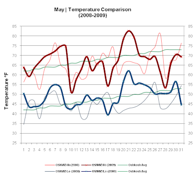
After the above average temperatures and dry conditions of two weeks ago, this past week was just the opposite. Temperatures dropped below average and the rains came. The maximum temperature for the 24 hour period ending on May 28 never broke the 60° mark, topping out at 53.4°. There were four days in a row where we measured accumulating precipitation here at OSNW3. Two of those days were at or above three tenths of an inch. A thunderstorm rumbled through as well on May 30 during the late morning hours creating a 15 minute rain delay as we made the turn at Lakeshore . Overall May of 2009 was below average... in temperature (2nd straight year) and precipitation (3rd straight year). Also, May of 2009 was cloudier than the previous two. Click here for the "Days With Sun" data. ( OSNW3 May Observations ) (Temp Comparison 2008 / 2009 | May 1 - 31) Max Avg: 65.5 / 66.9 / +1.4 Min Avg: 45.3 / 49.4 / +4.1 (May 2009 Precipitation | May 1 - 31) 2009 Monthly Total Precip.. 2.39...