Posts

Showing posts with the label Lake Winnebago

First Wind & Waves of 2013
Image
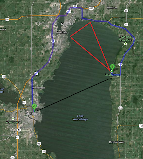
On Saturday October 26th my daughter and I ventured to Calumet County Park . County Park is located almost directly across Lake Winnebago from Oshkosh. About 12 miles as the crow flies and 35 miles by northern road access. Upon arrival, traveling down the Niagara Escarpment , we were witness to an excited Lake Winnebago. Forecast from the NWS Green Bay foretold winds of 15-20 knots and waves of 3-4 feet. This forecast would verify. The sights and sounds were just what we were looking for. Colorful trees whipping wildly with the constant roar of the wind and crashing waves. And of course the playground set. We also witnessed a smoke plume off in the distance towards the northwest depicted in the map above by an approximate red triangle and in the image below by a red circle. It appeared something was burning in East central Calumet County at 2:30 this afternoon, the smoke plume was visible from Neenah. — Clint Harness (@snowfall4) October 26, 2013 Below is a short vid...

Spring Fever, The Next Cold Snap, Winter Fish Kill & March Madness

Image
Spring fever is in full bloom. I've been stricken with the fever, but I will admit I am not ready. This feeling leaves me with some sort of yard clean up anxiety that I cannot completely comprehend. Maybe it's the fact that I just don't want to give up the snugness my winter hat gives me. Regardless, temperatures for the month of March thus far are way above average as one would expect, 7.4 degrees above the mean average (81-10) to be exact. Based on the temperature trend projected by Lezak's Recurring Cycle theory , this warmer than average trend should last until the end of the month when a few shots of colder air are likely. ( OSNW3 Weather Brief ) ( OSNW3 March Observations ) (OSNW3 March 2012 Summary) (click on graph for the month summary data - it will open a new tab/window) ---- These warm March conditions are emitting a false sense of season and the longevity of them allow me ample time to ponder the next potential cold snap. Following the tempe...

Near Stationary Cut-off Low

Image
I took the opportunity to get out in the elements with mother nature as the area faced it's first real taste of a fall storm system. The nearly stationary low blew consistent northeasterly winds the morning of Sep 26. Gusts close to 30 mph stirred Lake Winnebago initiating a moderate wave event on it's western shores. Some Photos . (Sep 26, 2011) Some Videos . 4 new ones. (Sep 26, 2001) The precipitation from this low pressure thus far has tallied 1.23", dropping measurable precipitation on six of seven days. The NWS GRB labeled it as 'pesky', I guess after seven days it could become a bit pesky. Overall though, the weather hasn't been all that nasty. Sep 26 was really the only harsh day. To view the radar loop of the storm entering into the US and then deciding to cut off, click here . (20MB) Once it turned from cloudy, raining, and windy to sunny and calm on Sep 26, I captured this satellite image. Impressive.

A Typical First Half Of April

Image
I believe the weather we've been experiencing this first half of April is quite typical of what one should expect. A volatile atmosphere swinging up and down as the transition to spring takes place. I will admit I am itching to get out on the golf course. Last year at this time I was closing in on my first 18 being logged into the record book. Thinking back to April 2010, it's shocking to realize that this April to date has been 12.1 degrees cooler regarding daily max temps. However, with only two days above 60 degrees thus far we are still above the Oshkosh average by 2.2 degrees. As for precipitation we are just 4 tenths of an inch below the Oshkosh average. A fairly typical first half of April in my opinion. Still though, I am in search of a warm spell no matter how typical it has been. It would seem one is about two weeks away according to the OSNW3 backyard max temp forecast using the LRC. There is much work to refine the technique, I will admit, but none the less, ...

Early Autumn Heavyweights

Image
Ahh, the cool and crisp air of autumn. The end of this week has been the most pleasant string of days I can remember. However, we all know the saying "In Like a Lion...". I would venture and say that the 2010 meteorological autumn came in just like that. Last weekend and the early part of this week our region dealt with two potent low pressure systems that dropped the temperatures and pumped up the winds. I recall acknowledging the high dew points of the summer and foreseeing an extra chill on my skin once they left. The cooler air of September came rolling in but I acclimated quickly. I welcome back autumn with open arms. Forecasts call for a cooler than average period through next weekend. ( OSNW3 Weather Brief ) ( OSNW3 September Observations ) (OSNW3 September 2010 Summary) (click on graph for the month summary data - it will open a new tab/window) ---- Thrills Of Autumn Temperature and wind, they have been relatively pleasant the past couple months. The two low pr...

Another Dry September

Image
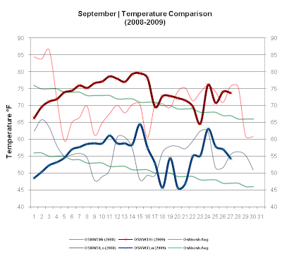
The first 20 observed days of September brought nothing to the rain gauge. With that said, September of 2009 is not far behind 2008, continuing the dryness of the past 2 years for the month. Just .08" behind 2008, we are considerably below the Oshkosh average for September ( Annual Precipitation ). Temperatures have been above average for the most part the entire month, but a cool down is in the near forecast. ( OSNW3 September Observations ) (Temp Comparison 2008 / 2009 | September 1 - 27) Max Avg: 71.1 / 73.7 / +2.6 Min Avg: 56.1 / 55.4 / -0.7 (September 2009 Precipitation | September 1 - 27) 2009 Monthly Total Precip.. 1.23" Oshkosh Average Precip.. 3.47" Departure Precip.. -2.24" ---- Consecutive Days Without Precipitation This past dry spell has become the longest ever observed at OSNW3. 1. Aug 31, 2009 - Sep 20, 2009 (21 days) 2. Feb 5, 2007 - Feb 23, 2007 (19 days) 3. Apr 2, 2009 - Apr 18, 2009 (17 days) (OSNW3 - Consecutive Days Without Precipitation) -...