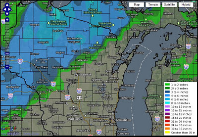
What could have been. The annual first week of December storm was in full effect for all of WI, but the case for the eastern portions of the state in 2011 was rain with temps in the 40s. Year after year a storm works it's way into the western Great Lakes the first week of December. Most notable in recent history is Dec 2, 2007. Clicking the links below will open the daily climate for December for that particular year. A radar loop is obtainable by clicking the linked daily weather description. 200612 , 200712 , 200812 , 200912 , 201012 . (Snowfall Analysis ending 7am Dec 4, 2011) We should all be aware that when this storm recurs around Jan 20, 2012 our area could be in the bullseye for the snowfall. Let's hope so! It could make for a snowy Conference Championship game at Lambeau! ( OSNW3 Weather Brief ) ( OSNW3 December Observations ) (OSNW3 December 2011 Summary) (click on graph for the month summary data - it will open a new tab/window) ---- Lake Winnebago...