Posts

Showing posts with the label July Summary

July Summary

Image
To the summer time standard in Wisconsin, July began cool. Summer quickly got back on track however. The month steadied as warmer temperatures moved in. A mini heat wave soon followed and Oshkosh recorded five consecutive days with high temperatures at or above 90 degrees. Overnight temperatures were warm as well. On the 19th the low temperature only fell to 77 degrees, placing it as the tenth all-time warmest low temperature in Oshkosh history for the month of July. The heat broke on the 20th and ushered in pleasant outdoor conditions. After seven days of daily highs in the 70s, temperatures took free fall. An unseasonably cool air mass muscled in. Combined with clouds and wind, day time temperatures struggled to maintain readings in the 60s. High temperatures on the 27th and 28th of the month were the coldest ever recorded for those dates. Precipitation ended below average for the month. The official rain gauge for the city tallied 2.55 inches, which is over an inch below average...

The Truth of a Heat Wave

Image
It is insane when a temperature of 90 degrees and a dew point of 70 degress brings on a feeling of relief. In Wisconsin this feeling only takes place during an extended heat wave in the middle of summer. That is exactly where we are at. We've been doing our best to keep hydrated and keep the sunscreen applied while outdoors. As for being inside the house we feel very fortunate to have central air to keep things comfortable. Looking ahead there might be a 24 hour period early next week that provides some relief from the heat, but the heat will return and stay with us for another extended period of time. Anyone following the LRC theory (Lezak's Recurring Cycle) knew the recent warmth was coming with great potential to provide extreme summer weather. This part of the pattern has been documented thoroughly via LRC Weather , WeatherWatch12 , and even here at OSNW3 . This coming week is the pattern feature that brought us our first heatwave of the summer back in early June. Th...

Summer Time

Image
July ends on a dry spell, so to speak. Only 0.20" in the last seven days. The two tenths round out the month completing the wettest July in Oshkosh's history. 11.84" were recorded here at OSNW3. More on the record rain in July from the NWS, here . The 6-10 and 8-14 day forecast calls for more above average temperatures and precipitation. **Addendum : Moister Than Most is a great "top news of the day" entry from the NWS in the Twin Cities. It references the many reasons for the heavy rainfall we have experienced this Summer. ( OSNW3 Weather Brief ) ( OSNW3 August Observations ) (OSNW3 August 2010 Summary) (click on graph for the month summary data - it will open a new tab/window) ---- CoCoRaHS : Summer Precipitation Comparison Precipitation can vary drastically from one backyard to the next. Especially during the Summer months when Thunderstorms drop locally heavy rains. OSNW3 has recorded three days this Summer with 24hr precipitation totals of over two ...

Here Comes The Heat

Image
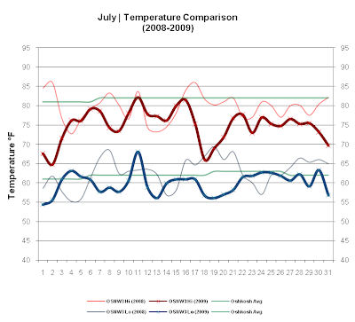
It was only a matter of time until the pattern changed and the heat would arrive. It's Summer after all, it will get hot. The highly talked about coolness of July is a thing of the past. The upcoming weekend sees forecast temps in the upper 80's, with a possibility of topping 90. The dew point will be up and it will feel sultry. Dog days of Summer will soon be here... but for how long? No matter! Bring it! ( OSNW3 August Observations ) ---- OSNW3 July 2009 Climate Summary (Temp Comparison 2008 / 2009 | July 1 - 31) Max Avg: 79.6 / 74.9 / -4.7 Min Avg: 62.7 / 59.9 / -2.8 - (July 2009 Temperature | July 1 - 31) OSNW3 2009 Average Avg Hi... 74.9 Avg Low.. 59.9 Oshkosh Average Avg Hi... 81.8 Avg Low.. 62.1 Departure Avg Hi... -6.9 Avg Low.. -2.2 - (July 2007-2009 Mean Temperature) - (July 2009 Precipitation | July 1 - 31) 2009 Monthly Total Precip.. 2.16" Oshkosh Average Precip.. 3.58" Departure Precip.. -1.42" - (OSNW3 Dog Days Through July 2009) - (OSNW3...