Posts

Showing posts with the label April Snowfall

A Cool and Wet April Rolls into May

Image
Total confusion of the senses for my wife and I last week. Shortly after the snowstorm we were jet setting to Jamaica to watch friends of ours tie the knot. My white skin did not fair well against the intense sunshine of the Caribbean. I learned that multiple reapplications of UV defense is necessary. Enough about my ineptitude of skin care. April at OSNW3 was a deluge of historical proportions. As Tony stated in the comments of the last entry, "you might want to consider putting in a rice paddy this year". The entire time we were away standing water was present on the webcam image. It has since receded and just recently started to actually dry out. The drying out trend will attempt to sustain itself until the 'signature' storm of this years LRC returns sometime around May 12. After the storm our cool and soaked spring will continue to roll on. A wonderful cycle of patterns for a snow lover during the winter months but not so for an avid golfer during the spr...
Post Winter Storm Report - Apr 19

Image
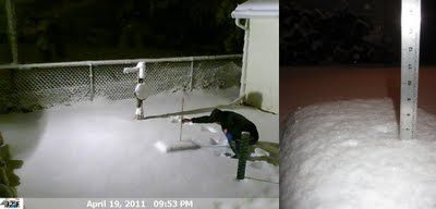
The snow started about 11am on Apr 19 and intensified as the day progressed. The afternoon brought many bolts of lightning and claps of thunder. By the time I was able to leave Holland, WI my car was covered in about six inches of fresh heavy wet snow. The drive back to Oshkosh was long and tedious as roads were snow covered. Winds were whipping as well enhancing the low visibilities. I was able to snap a few photos in Holland and get a measurement once I got home. At the time of observation the wind was gusting considerably and the snow was winding down. A radar loop and a webcam time lapse can be found by clicking the links. A few photos of the storm are located here . Precip: 1.23" Snow: 6.4" Snowdepth: 6" (Apr 19, 2011 - 6.4" - 9:53pm) (Apr 19, 2011 - Rain Gauge) (Apr 19, 2001 - Weight Of Snow) (Apr 19, 2011 - Holland, WI - 1pm) (Apr 19, 2011 - Holland, WI - 7pm) ---- April Snow Stats I quickly gathered the all-time greatest snowfalls in Oshkosh for the ...

Early Spring 101

Image
This past week was a great lesson for those who are unfamiliar with Spring in this region. It featured our first thunderstorms since last August and our second snow of the Spring season here at OSNW3. The thunderstorms had heavy downpours embedded in them that brought minor street/field flooding. Over an inch and a half of rain was recorded for the 24hr period ending Apr 7. The snow, which accumulated over three inches, provided a peaceful winter scene for a half of day before it melted off. With the warmth of March and the beginning of April thus far, I foresee cool times ahead during the month of May. In the nearer future though, forecasts call for seasonable weather with a couple Summer like days squashed between it all. ( OSNW3 Weather Brief ) ( OSNW3 April Observations ) (OSNW3 April 2010 Summary) (click on graph for the month summary data - it will open a new tab/window) ---- Weekly Snowfall We had two consecutive days with measurable snow at OSNW3 this past week. The snow...