Posts

Showing posts with the label Annual Precipitation

August Summary, 2012 Summer & Annual Precipitation Update

Image
OSNW3 August 2012 Daily Observations OSNW3 August 2012 Summary (click on graph for the month summary data - it will open a new tab/window) Summer 2012 - 4th Warmest in Oshkosh History (click on image for entire list - it will open a new tab/window) Annual Precipitation OSNW3 is 3.97 inches above the Oshkosh 30 year average through August.

Another Dry August

Image
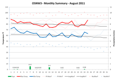
August is nearing it's end and we here in Oshkosh have had yet another below average August in the precipitation department. A recurring theme the past four years. OSNW3 is currently 2.92 inches below the Oshkosh average (1971-2000) precipitation for the month of August, just 29% of average. The forecast for the remainder of August doesn't provide much of a chance of raising that percentage either. ( OSNW3 Weather Brief ) ( OSNW3 August Observations ) (OSNW3 August 2011 Summary) (click on graph for the month summary data - it will open a new tab/window) ---- Precipitation Totals Through Aug 25, 2011 Our surplus of precipitation is taking a hit this August. Down almost three inches since July from 6.17 inches of surplus precipitation to 3.25 inches of surplus precipitation. It's evident in the surroundings, our grass is turning brown and the trees are starting to quickly lose their green. Dry conditions with cool nights will certainly speed the foliage changin...

Summer is in Full Swing

Image
Our recent pattern has included this years 'signature' storm, the infamous ' Great Lakes Cyclone ', and it's passing. With the jet stream weakening and lifting north the potency of this feature in our area has faded. For warm weather enthusiasts it is a good thing as the cool air that followed each instance this winter and early spring will not reoccur. Instead temperatures should hold around average for this time of year. As the patterns continue to cycle however, I have a sneaky feeling that the setup for what was our first heat wave in early June will show up again near the end of July giving us a chance at a string of extremely hot days. We'll see. For a detailed look back at June click here . ( OSNW3 Weather Brief ) ( OSNW3 July Observations ) (OSNW3 July 2011 Summary) (click on graph for the month summary data - it will open a new tab/window) ---- Precipitation Totals Through June As we move beyond the half way point of 2011 here at OSNW3 we h...

October Climate Summary, Annual Precipitation and the LRC

Image
October of 2010 was a tranquil month with one exception, the Great Lakes Cyclone . OSNW3 ended the month 1.8 degrees above the Oshkosh mean temperature and 0.40 inches above the Oshkosh precipitation average. We recorded no snowfall. A record was broken at my location on Oct 26, when 1.14" of rainfall was recorded for the 24hr period. As for November , the near future is forecasting average temperatures with small chances of precipitation while a more mild and wet period may be awaiting us in two weeks. ( OSNW3 Weather Brief ) ( OSNW3 October Observations ) (OSNW3 October 2010 Summary) (click on graph for the month summary data - it will open a new tab/window) ---- Annual Precipitation Through October 31st, OSNW3 has recorded 35.96 inches of precipitation. Creeping ever closer to our soaking in 2008 which produced 40.86 inches of precipitation. (OSNW3 Precipitation Summary - Annual Total) (OSNW3 Precipitation Summary - Monthly Total) ---- More Winter Snowfall Outlook Jabber I h...

The Summer Afterglow

Image
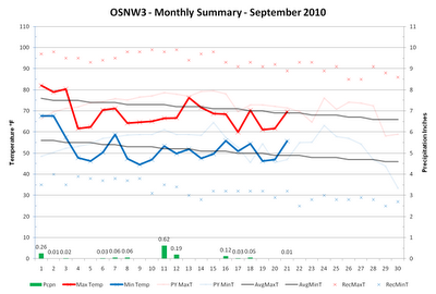
Last week my wife told me that her and her co-workers can't recall a school year starting out so chilly. I think it's just the afterglow of a warm summer. Either way, temperatures for the most part have managed to stay below average the past eleven days. Along with the relative chill are the many days with precipitation as well. Our mean temperature for the month stands at 60.5 and our days with measurable precipitation at 12. After the potentially wet and stormy weather in the coming days, long range, 6-14 day, forecasts call for above average temps and below average precip. Conditions that are typical with La Nina for our region this time of year. ( OSNW3 Weather Brief ) ( OSNW3 September Observations ) (OSNW3 September 2010 Summary) (click on graph for the month summary data - it will open a new tab/window) ---- Annual Precipitation The last week of August and the first half of September have recorded lower amounts of precipitation and are allowing for a nice drying tren...

A Summer-like Late May

Image
Hot and steamy were the operative words across most of the region the early part of this week. In my opinion, the temps and dew points between May 23 and May 26 proved to be just what the doctor ordered. The heat and humidity does wonders for my skin, my short game, and my thirst for quality brews. Keep it coming, please. However, thanks to a cold front that dropped through the Great Lakes, the month will end on a more comfortable note and we will again be able to open the windows and enjoy the outside air, inside. Looking forward, the first part of June is forecast to be seasonal. ( OSNW3 Weather Brief ) ( OSNW3 May Observations ) (OSNW3 May 2010 Summary) (click on graph for the month summary data - it will open a new tab/window) ---- Dog Days of May? The recent heat wave provided a few days that I like to define as "dog days". Somewhat similar to the "Winter Duration" formula I compare "Summer" (May-Sep) min and max temperatures. It is reasonable to c...